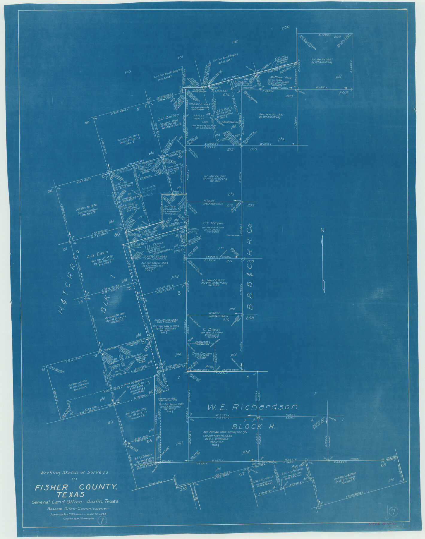
Fisher County Working Sketch 7
- 
                          Map/Doc69141
- 
                            CollectionGeneral Map Collection
- 
                            Object Dates6/12/1944 (Creation Date)
- 
                            People and OrganizationsW. S. Brewington (Draftsman)
- 
                            CountiesFisher
- 
                            SubjectsSurveying Working Sketch
- 
                            Height x Width36.7 x 28.9 inches93.2 x 73.4 cm
- 
                            Scale1" = 500 varas
Part of: General Map Collection
            Brazos County Working Sketch 4


                                            Print $20.00                    
                                             -                         Digital $50.00                                    
                Brazos County Working Sketch 4
1976
Size 22.5 x 20.6 inches
                                Map/Doc 67479
            
            Floyd County Sketch File 28


                                            Print $20.00                    
                                             -                         Digital $50.00                                    
                Floyd County Sketch File 28
Size 17.4 x 18.6 inches
                                Map/Doc 11487
            
            Flight Mission No. BQR-3K, Frame 156, Brazoria County


                                            Print $20.00                    
                                             -                         Digital $50.00                                    
                Flight Mission No. BQR-3K, Frame 156, Brazoria County
1952
Size 18.6 x 22.4 inches
                                Map/Doc 83983
            
            [San Antonio & Aransas Pass]
            
                                    ![64208, [San Antonio & Aransas Pass], General Map Collection](https://historictexasmaps.com/wmedia_w700/maps/64208.tif.jpg) 


    ![64208, [San Antonio & Aransas Pass], General Map Collection](https://historictexasmaps.com/wmedia_w700/maps/64208.tif.jpg) 
                                
            
                                            Print $40.00                    
                                             -                         Digital $50.00                                    
                [San Antonio & Aransas Pass]
Size 17.0 x 50.7 inches
                                Map/Doc 64208
            
            Aransas County Rolled Sketch 24A


                                            Print $20.00                    
                                             -                         Digital $50.00                                    
                Aransas County Rolled Sketch 24A
Size 15.8 x 24.1 inches
                                Map/Doc 5062
            
            Orange County Rolled Sketch 29


                                            Print $20.00                    
                                             -                         Digital $50.00                                    
                Orange County Rolled Sketch 29
1960
Size 25.9 x 37.2 inches
                                Map/Doc 7187
            
            Map of Haskell County Young District


                                            Print $20.00                    
                                             -                         Digital $50.00                                    
                Map of Haskell County Young District
1859
Size 21.9 x 25.8 inches
                                Map/Doc 3641
            
            Bandera County Working Sketch 57


                                            Print $20.00                    
                                             -                         Digital $50.00                                    
                Bandera County Working Sketch 57
1991
Size 38.5 x 46.8 inches
                                Map/Doc 67653
            
            Orange County Working Sketch 54b


                                            Print $40.00                    
                                             -                         Digital $50.00                                    
                Orange County Working Sketch 54b
2008
Size 38.0 x 50.3 inches
                                Map/Doc 88743
            
            [Corpus Christi Bay, Padre Island, Mustang Island, Laguna de la Madre, King and Kenedy's Pasture]
            
                                    ![73040, [Corpus Christi Bay, Padre Island, Mustang Island, Laguna de la Madre, King and Kenedy's Pasture], General Map Collection](https://historictexasmaps.com/wmedia_w700/maps/73040.tif.jpg) 


    ![73040, [Corpus Christi Bay, Padre Island, Mustang Island, Laguna de la Madre, King and Kenedy's Pasture], General Map Collection](https://historictexasmaps.com/wmedia_w700/maps/73040.tif.jpg) 
                                
            
                                            Print $20.00                    
                                             -                         Digital $50.00                                    
                [Corpus Christi Bay, Padre Island, Mustang Island, Laguna de la Madre, King and Kenedy's Pasture]
Size 18.2 x 27.0 inches
                                Map/Doc 73040
            
            Foard County Working Sketch 1


                                            Print $20.00                    
                                             -                         Digital $50.00                                    
                Foard County Working Sketch 1
1899
Size 20.5 x 22.8 inches
                                Map/Doc 69191
            
            Real County Rolled Sketch 12A


                                            Print $20.00                    
                                             -                         Digital $50.00                                    
                Real County Rolled Sketch 12A
Size 36.2 x 38.3 inches
                                Map/Doc 9837
            You may also like
            Anderson County Rolled Sketch 6


                                            Print $40.00                    
                                             -                         Digital $50.00                                    
                Anderson County Rolled Sketch 6
Size 93.3 x 43.5 inches
                                Map/Doc 81901
            
            Oldham County Rolled Sketch 2


                                            Print $40.00                    
                                             -                         Digital $50.00                                    
                Oldham County Rolled Sketch 2
1886
Size 35.7 x 55.1 inches
                                Map/Doc 9639
            
            [Connections of Blocks C-17, B-59, T6 and C-11]
            
                                    ![93067, [Connections of Blocks C-17, B-59, T6 and C-11], Twichell Survey Records](https://historictexasmaps.com/wmedia_w700/maps/93067-1.tif.jpg) 


    ![93067, [Connections of Blocks C-17, B-59, T6 and C-11], Twichell Survey Records](https://historictexasmaps.com/wmedia_w700/maps/93067-1.tif.jpg) 
                                
            
                                            Print $20.00                    
                                             -                         Digital $50.00                                    
                [Connections of Blocks C-17, B-59, T6 and C-11]
Size 31.2 x 28.0 inches
                                Map/Doc 93067
            
            Right of Way & Track Map San Antonio & Aransas Pass Railway Co.


                                            Print $40.00                    
                                             -                         Digital $50.00                                    
                Right of Way & Track Map San Antonio & Aransas Pass Railway Co.
1919
Size 25.3 x 56.5 inches
                                Map/Doc 64024
            
            Concho County Working Sketch 23


                                            Print $20.00                    
                                             -                         Digital $50.00                                    
                Concho County Working Sketch 23
1975
Size 21.9 x 27.1 inches
                                Map/Doc 68205
            
            Upton County Rolled Sketch JSP


                                            Print $40.00                    
                                             -                         Digital $50.00                                    
                Upton County Rolled Sketch JSP
1937
Size 39.2 x 68.0 inches
                                Map/Doc 10042
            
            Coke County Sketch File 35


                                            Print $6.00                    
                                             -                         Digital $50.00                                    
                Coke County Sketch File 35
1967
Size 14.2 x 8.6 inches
                                Map/Doc 18649
            
            The Republic County of Jefferson. December 29, 1845


                                            Print $20.00                    
                                    
                The Republic County of Jefferson. December 29, 1845
2020
Size 22.6 x 21.7 inches
                                Map/Doc 96201
            
            Galveston Entrance, Texas From a Trigonometrical Survey Under the direction of A.D. Bache Superintendent of the Survey of the Coast of the United States


                                            Print $20.00                    
                                             -                         Digital $50.00                                    
                Galveston Entrance, Texas From a Trigonometrical Survey Under the direction of A.D. Bache Superintendent of the Survey of the Coast of the United States
1853
Size 15.9 x 19.3 inches
                                Map/Doc 93998
            
            Culberson County Working Sketch 49


                                            Print $40.00                    
                                             -                         Digital $50.00                                    
                Culberson County Working Sketch 49
1972
Size 49.2 x 37.6 inches
                                Map/Doc 68503
            
            Red River County Working Sketch 8


                                            Print $20.00                    
                                             -                         Digital $50.00                                    
                Red River County Working Sketch 8
1920
Size 16.2 x 14.2 inches
                                Map/Doc 71991
            
            [Surveys along Red River in Hartley County]
            
                                    ![90739, [Surveys along Red River in Hartley County], Twichell Survey Records](https://historictexasmaps.com/wmedia_w700/maps/90739-1.tif.jpg) 


    ![90739, [Surveys along Red River in Hartley County], Twichell Survey Records](https://historictexasmaps.com/wmedia_w700/maps/90739-1.tif.jpg) 
                                
            
                                            Print $20.00                    
                                             -                         Digital $50.00                                    
                [Surveys along Red River in Hartley County]
Size 22.0 x 16.7 inches
                                Map/Doc 90739
            