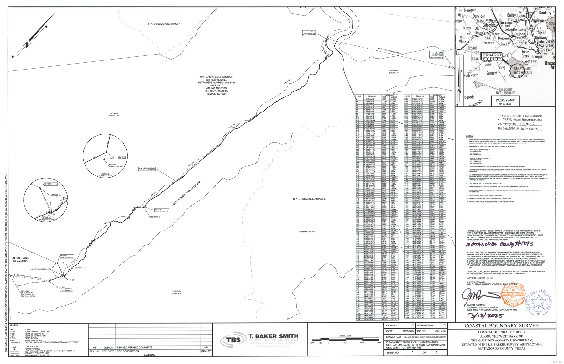
Matagorda County NRC Article 33.136 Sketch 21
Coastal Boundary Survey along the west bank of the Gulf Intracoastal Waterway, situated in the L.E. Parker survey, Abstract 464, Matagorda County, Texas
-
Map/Doc
97429
-
Collection
General Map Collection
-
Object Dates
3/13/2025 (Creation Date)
5/6/2025 (File Date)
8/12/2024 (Survey Date)
-
People and Organizations
James M. Naismith (Surveyor/Engineer)
-
Counties
Matagorda
-
Subjects
Surveying CBS
-
Scale
1" = 300 feet
-
Comments
Project: Cedar Lakes, DU, Parker Survey A-464-Naismith 8-12-24
Project No.: GLO# SL20250037
Part of: General Map Collection
Flight Mission No. DQO-3K, Frame 20, Galveston County

Print $20.00
- Digital $50.00
Flight Mission No. DQO-3K, Frame 20, Galveston County
1952
Size 18.8 x 22.6 inches
Map/Doc 85061
Flight Mission No. BRA-6M, Frame 153, Jefferson County

Print $20.00
- Digital $50.00
Flight Mission No. BRA-6M, Frame 153, Jefferson County
1953
Size 18.5 x 22.2 inches
Map/Doc 85454
Roberts County Sketch File 7

Print $16.00
- Digital $50.00
Roberts County Sketch File 7
1992
Size 14.3 x 8.8 inches
Map/Doc 35316
Hutchinson County Working Sketch 14

Print $20.00
- Digital $50.00
Hutchinson County Working Sketch 14
1930
Size 18.4 x 25.8 inches
Map/Doc 66372
Controlled Mosaic by Jack Amman Photogrammetric Engineers, Inc - Sheet 20

Print $20.00
- Digital $50.00
Controlled Mosaic by Jack Amman Photogrammetric Engineers, Inc - Sheet 20
1954
Size 20.0 x 24.0 inches
Map/Doc 83467
Eastland County Working Sketch 26

Print $20.00
- Digital $50.00
Eastland County Working Sketch 26
1948
Size 21.4 x 19.0 inches
Map/Doc 68807
Uvalde County Working Sketch 49

Print $20.00
- Digital $50.00
Uvalde County Working Sketch 49
1980
Size 35.4 x 44.7 inches
Map/Doc 72119
Port of Corpus Christi Inner Harbor Industrial District, Nueces County Navigation District Number One

Print $40.00
- Digital $50.00
Port of Corpus Christi Inner Harbor Industrial District, Nueces County Navigation District Number One
1972
Size 43.6 x 101.3 inches
Map/Doc 78635
Starr County Rolled Sketch 44

Print $20.00
- Digital $50.00
Starr County Rolled Sketch 44
Size 38.0 x 46.0 inches
Map/Doc 9943
Swisher County Sketch File 19

Print $16.00
- Digital $50.00
Swisher County Sketch File 19
1913
Size 10.0 x 6.5 inches
Map/Doc 37662
Borden County Boundary File 4

Print $66.00
- Digital $50.00
Borden County Boundary File 4
1908
Size 23.7 x 125.7 inches
Map/Doc 1694
Erath County Rolled Sketch 3A

Print $20.00
- Digital $50.00
Erath County Rolled Sketch 3A
1982
Size 21.7 x 27.8 inches
Map/Doc 5865
You may also like
[Houston & Texas Central Ry.]
![64363, [Houston & Texas Central Ry.], General Map Collection](https://historictexasmaps.com/wmedia_w700/maps/64363.tif.jpg)
Print $20.00
- Digital $50.00
[Houston & Texas Central Ry.]
1939
Size 15.5 x 13.8 inches
Map/Doc 64363
Harbor Pass and Bar at Brazos Santiago, Texas

Print $20.00
- Digital $50.00
Harbor Pass and Bar at Brazos Santiago, Texas
1871
Size 26.8 x 18.3 inches
Map/Doc 72984
[Portion of Thomas Kelly Subdivision in Parmer and Castro Counties, Texas]
![92550, [Portion of Thomas Kelly Subdivision in Parmer and Castro Counties, Texas], Twichell Survey Records](https://historictexasmaps.com/wmedia_w700/maps/92550-1.tif.jpg)
Print $20.00
- Digital $50.00
[Portion of Thomas Kelly Subdivision in Parmer and Castro Counties, Texas]
1906
Size 20.3 x 16.4 inches
Map/Doc 92550
Cottle County Working Sketch 24

Print $20.00
- Digital $50.00
Cottle County Working Sketch 24
2014
Size 10.6 x 18.3 inches
Map/Doc 93707
Flight Mission No. DQN-5K, Frame 52, Calhoun County

Print $20.00
- Digital $50.00
Flight Mission No. DQN-5K, Frame 52, Calhoun County
1953
Size 18.6 x 22.3 inches
Map/Doc 84397
Flight Mission No. DQO-3K, Frame 41, Galveston County

Print $20.00
- Digital $50.00
Flight Mission No. DQO-3K, Frame 41, Galveston County
1952
Size 18.7 x 22.5 inches
Map/Doc 85082
Flight Mission No. DQN-2K, Frame 93, Calhoun County

Print $20.00
- Digital $50.00
Flight Mission No. DQN-2K, Frame 93, Calhoun County
1953
Size 16.5 x 16.2 inches
Map/Doc 84283
Caldwell County Sketch File 4a

Print $8.00
- Digital $50.00
Caldwell County Sketch File 4a
1898
Size 11.2 x 8.8 inches
Map/Doc 35835
Childress County Rolled Sketch 9B

Print $20.00
- Digital $50.00
Childress County Rolled Sketch 9B
Size 17.3 x 23.6 inches
Map/Doc 5448
Map of Texas Gulf Coast and Continental Shelf showing Natural Gas Pipe Lines

Print $40.00
- Digital $50.00
Map of Texas Gulf Coast and Continental Shelf showing Natural Gas Pipe Lines
1983
Size 40.9 x 59.1 inches
Map/Doc 75969
Dickens County Sketch File D

Print $20.00
- Digital $50.00
Dickens County Sketch File D
1883
Size 15.7 x 14.8 inches
Map/Doc 11330
Glasscock County Rolled Sketch 6

Print $20.00
- Digital $50.00
Glasscock County Rolled Sketch 6
1946
Size 19.9 x 22.5 inches
Map/Doc 6017