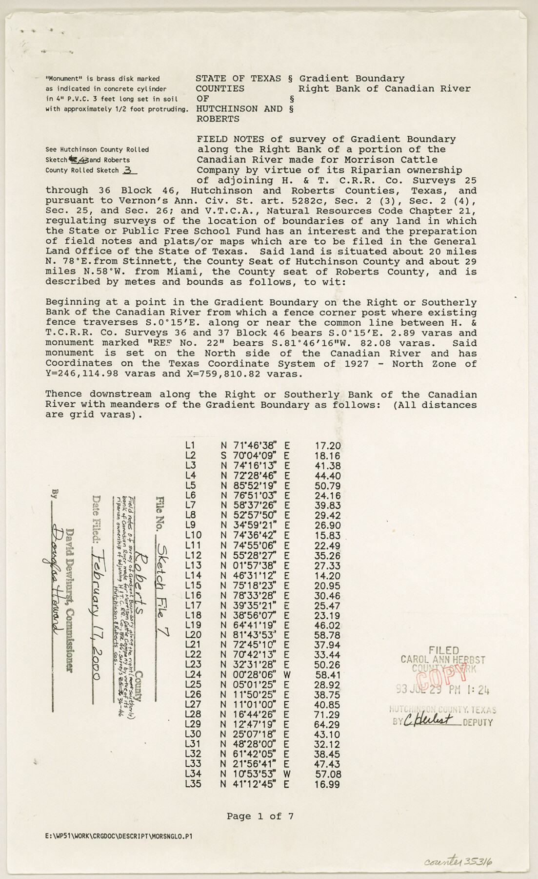
Roberts County Sketch File 7
[Field notes of survey of gradient boundary along the right bank of a portion of the Canadian River made for Morrison Cattle Company by virtue of its riparian ownership of adjoining H. & T. C. R.R. Co. surveys 25 through 36, Block 46]
-
Map/Doc
35316
-
Collection
General Map Collection
-
Object Dates
1992 (Creation Date)
2/17/2000 (File Date)
Sept. 8 - Oct. 22/1992 (Survey Date)
-
People and Organizations
Wm. C. Wilson, Jr. (Surveyor/Engineer)
A.K. "Bud" McMahan (Chainman/Field Personnel)
Gerald McMahan (Chainman/Field Personnel)
Ronald Johnson (Chainman/Field Personnel)
-
Counties
Roberts Hutchinson
-
Subjects
Surveying Sketch File
-
Height x Width
14.3 x 8.8 inches
36.3 x 22.4 cm
-
Medium
paper, print
-
Comments
See Hutchinson County Rolled Sketch 43 (6311-6316) and Roberts County Rolled Sketch 3 (8354-8359).
-
Features
Canadian River
Related maps
Hutchinson County Rolled Sketch 43

Print $40.00
- Digital $50.00
Hutchinson County Rolled Sketch 43
1992
Size 38.0 x 49.4 inches
Map/Doc 6311
Hutchinson County Rolled Sketch 43

Print $40.00
- Digital $50.00
Hutchinson County Rolled Sketch 43
1992
Size 40.5 x 49.4 inches
Map/Doc 6312
Hutchinson County Rolled Sketch 43

Print $40.00
- Digital $50.00
Hutchinson County Rolled Sketch 43
1992
Size 40.4 x 49.4 inches
Map/Doc 6313
Hutchinson County Rolled Sketch 43

Print $40.00
- Digital $50.00
Hutchinson County Rolled Sketch 43
1992
Size 41.3 x 50.0 inches
Map/Doc 6314
Hutchinson County Rolled Sketch 43

Print $40.00
- Digital $50.00
Hutchinson County Rolled Sketch 43
1992
Size 40.6 x 49.9 inches
Map/Doc 6315
Hutchinson County Rolled Sketch 43

Print $40.00
- Digital $50.00
Hutchinson County Rolled Sketch 43
1992
Size 40.5 x 49.4 inches
Map/Doc 6316
Roberts County Rolled Sketch 3

Print $40.00
- Digital $50.00
Roberts County Rolled Sketch 3
Size 38.0 x 49.7 inches
Map/Doc 8354
Roberts County Rolled Sketch 3

Print $40.00
- Digital $50.00
Roberts County Rolled Sketch 3
Size 38.0 x 49.7 inches
Map/Doc 8355
Roberts County Rolled Sketch 3

Print $40.00
- Digital $50.00
Roberts County Rolled Sketch 3
Size 38.0 x 49.7 inches
Map/Doc 8356
Roberts County Rolled Sketch 3

Print $40.00
- Digital $50.00
Roberts County Rolled Sketch 3
Size 38.0 x 49.7 inches
Map/Doc 8357
Roberts County Rolled Sketch 3

Print $40.00
- Digital $50.00
Roberts County Rolled Sketch 3
Size 38.4 x 50.0 inches
Map/Doc 8358
Roberts County Rolled Sketch 3

Print $40.00
- Digital $50.00
Roberts County Rolled Sketch 3
Size 37.7 x 48.9 inches
Map/Doc 8359
Part of: General Map Collection
Montague County Working Sketch 16

Print $20.00
- Digital $50.00
Montague County Working Sketch 16
1946
Size 44.1 x 40.8 inches
Map/Doc 71082
Burleson County

Print $20.00
- Digital $50.00
Burleson County
1884
Size 21.9 x 25.2 inches
Map/Doc 3349
Lamb County Rolled Sketch 4

Print $20.00
- Digital $50.00
Lamb County Rolled Sketch 4
1917
Size 31.1 x 43.1 inches
Map/Doc 9414
Hemphill County Working Sketch 16

Print $20.00
- Digital $50.00
Hemphill County Working Sketch 16
1971
Size 27.0 x 40.0 inches
Map/Doc 66111
Schleicher County Sketch File 35

Print $20.00
- Digital $50.00
Schleicher County Sketch File 35
1951
Size 13.8 x 19.4 inches
Map/Doc 12308
Tyler County Sketch File 28

Print $46.00
- Digital $50.00
Tyler County Sketch File 28
1960
Size 9.8 x 8.6 inches
Map/Doc 38699
Reeves County Working Sketch 5

Print $20.00
- Digital $50.00
Reeves County Working Sketch 5
1938
Size 38.0 x 32.4 inches
Map/Doc 63448
Leon County Working Sketch 4

Print $20.00
- Digital $50.00
Leon County Working Sketch 4
Size 18.1 x 14.0 inches
Map/Doc 70403
Newton County Rolled Sketch 26

Print $397.00
- Digital $50.00
Newton County Rolled Sketch 26
1960
Size 10.9 x 15.4 inches
Map/Doc 47265
Goliad County Working Sketch 17

Print $20.00
- Digital $50.00
Goliad County Working Sketch 17
1949
Size 21.8 x 22.2 inches
Map/Doc 63207
Clay County Sketch File 24

Print $4.00
- Digital $50.00
Clay County Sketch File 24
1881
Size 18.9 x 23.0 inches
Map/Doc 11087
Brewster County Working Sketch 118

Print $20.00
- Digital $50.00
Brewster County Working Sketch 118
1929
Size 27.0 x 20.5 inches
Map/Doc 67718
You may also like
[Sketch for Mineral Application 19144 - Pecos River Bed]
![65573, [Sketch for Mineral Application 19144 - Pecos River Bed], General Map Collection](https://historictexasmaps.com/wmedia_w700/maps/65573.tif.jpg)
Print $20.00
- Digital $50.00
[Sketch for Mineral Application 19144 - Pecos River Bed]
1927
Size 45.2 x 46.4 inches
Map/Doc 65573
Oldham County Sketch File 4

Print $20.00
- Digital $50.00
Oldham County Sketch File 4
1883
Size 13.7 x 22.5 inches
Map/Doc 12111
Railroad Track Map, H&TCRRCo., Falls County, Texas

Print $4.00
- Digital $50.00
Railroad Track Map, H&TCRRCo., Falls County, Texas
1918
Size 11.7 x 18.5 inches
Map/Doc 62831
[Southwest corner of Runnels County School Land League 3]
![91586, [Southwest corner of Runnels County School Land League 3], Twichell Survey Records](https://historictexasmaps.com/wmedia_w700/maps/91586-1.tif.jpg)
Print $2.00
- Digital $50.00
[Southwest corner of Runnels County School Land League 3]
1927
Size 14.2 x 8.7 inches
Map/Doc 91586
[East Line of Moore County]
![91418, [East Line of Moore County], Twichell Survey Records](https://historictexasmaps.com/wmedia_w700/maps/91418-1.tif.jpg)
Print $20.00
- Digital $50.00
[East Line of Moore County]
Size 16.1 x 18.4 inches
Map/Doc 91418
Sutton County Sketch File 23

Print $30.00
- Digital $50.00
Sutton County Sketch File 23
1918
Size 14.2 x 8.5 inches
Map/Doc 37461
San Jacinto County Working Sketch 25

Print $20.00
- Digital $50.00
San Jacinto County Working Sketch 25
1943
Size 34.4 x 34.2 inches
Map/Doc 63738
[Northwest Garza Co., E. J. Powell surveys and vicinity]
![90852, [Northwest Garza Co., E. J. Powell surveys and vicinity], Twichell Survey Records](https://historictexasmaps.com/wmedia_w700/maps/90852-2.tif.jpg)
Print $2.00
- Digital $50.00
[Northwest Garza Co., E. J. Powell surveys and vicinity]
Size 8.9 x 14.2 inches
Map/Doc 90852
[Portion of Harris County]
![78481, [Portion of Harris County], General Map Collection](https://historictexasmaps.com/wmedia_w700/maps/78481.tif.jpg)
Print $2.00
- Digital $50.00
[Portion of Harris County]
Size 7.9 x 5.1 inches
Map/Doc 78481
Map and Street Guide of Austin, Texas and Urban Areas

Map and Street Guide of Austin, Texas and Urban Areas
1972
Size 48.6 x 33.9 inches
Map/Doc 82029
Kendall County Working Sketch 12

Print $20.00
- Digital $50.00
Kendall County Working Sketch 12
1966
Size 27.2 x 33.2 inches
Map/Doc 66684
Sketch Portion of Lamb County, Texas

Print $20.00
- Digital $50.00
Sketch Portion of Lamb County, Texas
1924
Size 19.9 x 21.4 inches
Map/Doc 92176