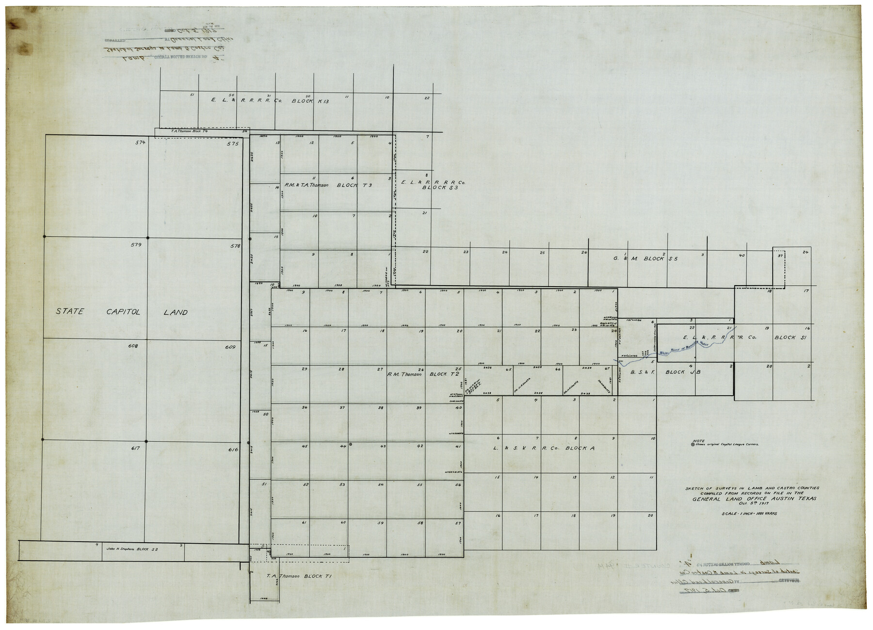
Lamb County Rolled Sketch 4
Sketch of surveys in Lamb and Castro Counties compiled from records on file in the General Land Office, Austin, Texas
-
Map/Doc
9414
-
Collection
General Map Collection
-
Object Dates
10/5/1917 (Creation Date)
-
Counties
Lamb Castro
-
Subjects
Surveying Rolled Sketch
-
Height x Width
31.1 x 43.1 inches
79.0 x 109.5 cm
-
Medium
linen, manuscript
-
Scale
1" = 1000 varas
Part of: General Map Collection
Nueces County NRC Article 33.136 Sketch 22

Print $42.00
Nueces County NRC Article 33.136 Sketch 22
2023
Map/Doc 97180
[Surveys in Austin's Colony along the San Bernardo River from the mouth of Peach Creek]
![209, [Surveys in Austin's Colony along the San Bernardo River from the mouth of Peach Creek], General Map Collection](https://historictexasmaps.com/wmedia_w700/maps/209.tif.jpg)
Print $20.00
- Digital $50.00
[Surveys in Austin's Colony along the San Bernardo River from the mouth of Peach Creek]
1821
Size 23.4 x 10.6 inches
Map/Doc 209
Coast Chart No. 210 Aransas Pass and Corpus Christi Bay with the coast to latitude 27° 12' Texas

Print $20.00
- Digital $50.00
Coast Chart No. 210 Aransas Pass and Corpus Christi Bay with the coast to latitude 27° 12' Texas
1913
Size 27.9 x 18.3 inches
Map/Doc 72805
Comal County Rolled Sketch 5

Print $20.00
- Digital $50.00
Comal County Rolled Sketch 5
1985
Size 30.6 x 26.7 inches
Map/Doc 5540
Loving County Working Sketch 11

Print $40.00
- Digital $50.00
Loving County Working Sketch 11
1957
Size 21.2 x 120.7 inches
Map/Doc 70643
Coast Chart No. 211 - Padre I. and Laguna Madre Lat. 27° 12' to Lat. 26° 33' Texas

Print $20.00
- Digital $50.00
Coast Chart No. 211 - Padre I. and Laguna Madre Lat. 27° 12' to Lat. 26° 33' Texas
1890
Size 27.5 x 18.2 inches
Map/Doc 72824
Zavala County Sketch File 35

Print $4.00
- Digital $50.00
Zavala County Sketch File 35
1887
Size 11.3 x 9.0 inches
Map/Doc 41397
Cherokee County Sketch File 32

Print $20.00
- Digital $50.00
Cherokee County Sketch File 32
Size 45.2 x 30.0 inches
Map/Doc 10334
Stonewall County Sketch File 26

Print $20.00
- Digital $50.00
Stonewall County Sketch File 26
1953
Size 35.7 x 36.8 inches
Map/Doc 10376

Gillespie County Sketch File 3a

Print $4.00
- Digital $50.00
Gillespie County Sketch File 3a
1860
Size 7.6 x 8.3 inches
Map/Doc 24131
Zavala County Working Sketch 26

Print $20.00
- Digital $50.00
Zavala County Working Sketch 26
1990
Size 22.4 x 27.9 inches
Map/Doc 62101
You may also like
Crosby County

Print $20.00
- Digital $50.00
Crosby County
1927
Size 41.2 x 36.4 inches
Map/Doc 95472
Working Sketch in Dickens and Crosby Cos.

Print $20.00
- Digital $50.00
Working Sketch in Dickens and Crosby Cos.
1910
Size 36.1 x 24.8 inches
Map/Doc 10771
Purchase Area Map, Ropesville Rural Communities, Hockley County, Texas

Print $40.00
- Digital $50.00
Purchase Area Map, Ropesville Rural Communities, Hockley County, Texas
1937
Size 52.9 x 29.3 inches
Map/Doc 89681
Maps of Gulf Intracoastal Waterway, Texas - Sabine River to the Rio Grande and connecting waterways including ship channels

Print $20.00
- Digital $50.00
Maps of Gulf Intracoastal Waterway, Texas - Sabine River to the Rio Grande and connecting waterways including ship channels
1966
Size 14.6 x 22.3 inches
Map/Doc 61956
South Part of Webb County

Print $40.00
- Digital $50.00
South Part of Webb County
1984
Size 41.2 x 61.5 inches
Map/Doc 77453
Upton County Boundary File 2a

Print $30.00
- Digital $50.00
Upton County Boundary File 2a
Size 14.4 x 9.0 inches
Map/Doc 59520
Map of the Lands Surveyed by the Memphis, El Paso & Pacific R.R. Company

Print $20.00
- Digital $50.00
Map of the Lands Surveyed by the Memphis, El Paso & Pacific R.R. Company
1860
Size 18.6 x 19.0 inches
Map/Doc 4846
Aransas County Sketch File 24

Print $36.00
- Digital $50.00
Aransas County Sketch File 24
1938
Size 10.9 x 8.3 inches
Map/Doc 13177
Mitchell County Sketch File 8

Print $20.00
- Digital $50.00
Mitchell County Sketch File 8
1909
Size 26.9 x 20.9 inches
Map/Doc 12098
Concho County Working Sketch 8

Print $20.00
- Digital $50.00
Concho County Working Sketch 8
1948
Size 47.0 x 42.6 inches
Map/Doc 68190
General Highway Map, Starr County, Texas

Print $20.00
General Highway Map, Starr County, Texas
1940
Size 24.8 x 18.5 inches
Map/Doc 79246
Flight Mission No. DCL-7C, Frame 97, Kenedy County

Print $20.00
- Digital $50.00
Flight Mission No. DCL-7C, Frame 97, Kenedy County
1943
Size 15.3 x 15.2 inches
Map/Doc 86069