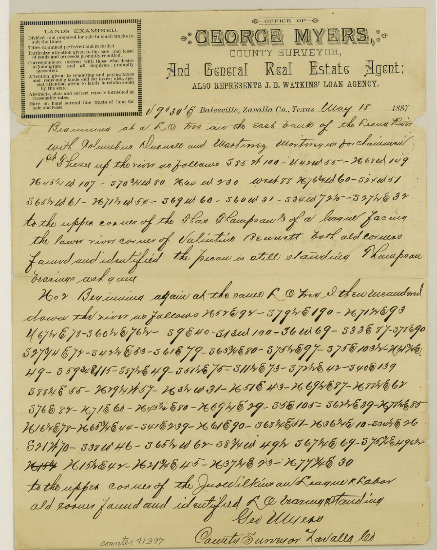
Zavala County Sketch File 35
[Connecting line from the east bank of Leona River to the upper corner of the John Wilkinson's league and labor survey]
-
Map/Doc
41397
-
Collection
General Map Collection
-
Object Dates
5/18/1887 (Creation Date)
-
People and Organizations
George Myers (Surveyor/Engineer)
-
Counties
Zavala
-
Subjects
Surveying Sketch File
-
Height x Width
11.3 x 9.0 inches
28.7 x 22.9 cm
-
Medium
paper, manuscript
-
Features
Leona River
Part of: General Map Collection
Gregg County Rolled Sketch 18A

Print $313.00
- Digital $50.00
Gregg County Rolled Sketch 18A
1934
Size 10.5 x 15.5 inches
Map/Doc 45469
Corpus Christi Pass, Texas

Print $20.00
- Digital $50.00
Corpus Christi Pass, Texas
1869
Size 24.3 x 18.2 inches
Map/Doc 72965
Map of Texas and the country adjacent

Print $20.00
- Digital $50.00
Map of Texas and the country adjacent
1844
Size 18.3 x 26.5 inches
Map/Doc 73052
Runnels County Rolled Sketch 36

Print $40.00
- Digital $50.00
Runnels County Rolled Sketch 36
Size 61.2 x 43.0 inches
Map/Doc 76027
Pecos County Rolled Sketch 125

Print $20.00
- Digital $50.00
Pecos County Rolled Sketch 125
1948
Size 32.0 x 41.6 inches
Map/Doc 7266
Grimes County Sketch File 5

Print $4.00
- Digital $50.00
Grimes County Sketch File 5
1881
Size 9.2 x 8.3 inches
Map/Doc 24642
Flight Mission No. CRE-1R, Frame 120, Jackson County

Print $20.00
- Digital $50.00
Flight Mission No. CRE-1R, Frame 120, Jackson County
1956
Size 16.1 x 15.9 inches
Map/Doc 85331
Denton County Working Sketch 18

Print $20.00
- Digital $50.00
Denton County Working Sketch 18
1975
Size 24.1 x 38.8 inches
Map/Doc 68623
Crane County Rolled Sketch 2

Print $40.00
- Digital $50.00
Crane County Rolled Sketch 2
1888
Size 55.3 x 29.0 inches
Map/Doc 8676
Marion County Working Sketch 7

Print $20.00
- Digital $50.00
Marion County Working Sketch 7
1918
Size 27.9 x 27.7 inches
Map/Doc 70782

Flight Mission No. DAG-23K, Frame 141, Matagorda County

Print $20.00
- Digital $50.00
Flight Mission No. DAG-23K, Frame 141, Matagorda County
1953
Size 18.7 x 22.4 inches
Map/Doc 86489
You may also like
Map of Texas Containing the Latest Grants and Discoveries

Print $20.00
Map of Texas Containing the Latest Grants and Discoveries
1836
Size 16.2 x 10.6 inches
Map/Doc 76245
Potter County Working Sketch 11

Print $20.00
- Digital $50.00
Potter County Working Sketch 11
1972
Size 27.4 x 26.4 inches
Map/Doc 71671
Flight Mission No. BRA-7M, Frame 86, Jefferson County

Print $20.00
- Digital $50.00
Flight Mission No. BRA-7M, Frame 86, Jefferson County
1953
Size 18.7 x 22.4 inches
Map/Doc 85508
Nueces County NRC Article 33.136 Sketch 15

Print $40.00
- Digital $50.00
Nueces County NRC Article 33.136 Sketch 15
2012
Size 18.0 x 24.0 inches
Map/Doc 93357
The North Coast of the Gulf of Mexico from St. Marks to Galveston

Print $20.00
- Digital $50.00
The North Coast of the Gulf of Mexico from St. Marks to Galveston
1844
Size 27.5 x 41.1 inches
Map/Doc 97396
Harris County Sketch File 104

Print $2.00
- Digital $50.00
Harris County Sketch File 104
1992
Size 11.2 x 8.9 inches
Map/Doc 25974
Clason's Guide Map Texas and Northern Mexico

Print $20.00
Clason's Guide Map Texas and Northern Mexico
1924
Size 21.3 x 28.4 inches
Map/Doc 76314
Map Showing the position of surveys 1 & 2, B.S. & F. Cert 1/356

Print $20.00
- Digital $50.00
Map Showing the position of surveys 1 & 2, B.S. & F. Cert 1/356
1915
Size 22.0 x 11.1 inches
Map/Doc 10768
Hale County Sketch File 3a

Print $20.00
- Digital $50.00
Hale County Sketch File 3a
Size 21.1 x 14.6 inches
Map/Doc 11593
Map of Texas. The Proposed Reoccupation of the Rio Grande -- Its Importance to the Union

Print $20.00
Map of Texas. The Proposed Reoccupation of the Rio Grande -- Its Importance to the Union
1965
Size 14.1 x 8.6 inches
Map/Doc 76264
Presidio County Rolled Sketch 112

Print $20.00
- Digital $50.00
Presidio County Rolled Sketch 112
1972
Size 22.8 x 36.5 inches
Map/Doc 7388
Map of the Fort Worth & Denver City Ry., Dallam County, Texas

Print $40.00
- Digital $50.00
Map of the Fort Worth & Denver City Ry., Dallam County, Texas
1887
Size 21.3 x 111.8 inches
Map/Doc 64352