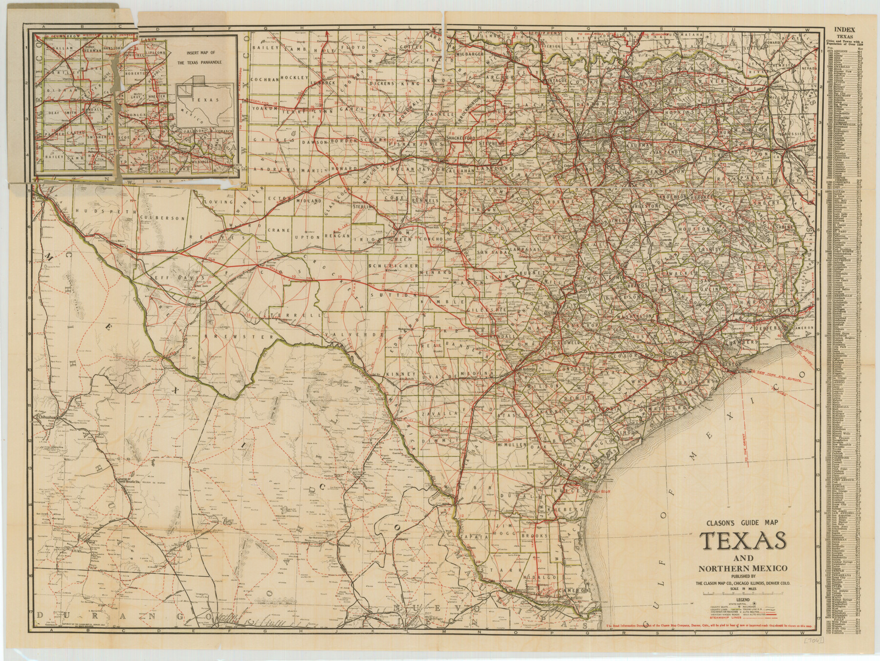
Clason's Guide Map Texas and Northern Mexico
-
Map/Doc
76314
-
Collection
Texas State Library and Archives
-
Object Dates
[1924] (Creation Date)
-
People and Organizations
The Clason Map Company (Publisher)
-
Subjects
Mexico State of Texas
-
Height x Width
21.3 x 28.4 inches
54.1 x 72.1 cm
-
Comments
Prints available courtesy of the Texas State Library and Archives.
More info can be found here: TSLAC Map 07067
Part of: Texas State Library and Archives
Section across Valley Bench and Terraces - South Side of Red River - Big Bend Area

Print $20.00
Section across Valley Bench and Terraces - South Side of Red River - Big Bend Area
1921
Size 10.2 x 34.8 inches
Map/Doc 79750
General Highway Map. Detail of Cities and Towns in Dallas County, Texas [Dallas and vicinity]
![79069, General Highway Map. Detail of Cities and Towns in Dallas County, Texas [Dallas and vicinity], Texas State Library and Archives](https://historictexasmaps.com/wmedia_w700/maps/79069.tif.jpg)
Print $20.00
General Highway Map. Detail of Cities and Towns in Dallas County, Texas [Dallas and vicinity]
1936
Size 18.4 x 25.2 inches
Map/Doc 79069
General Highway Map, Gaines County, Texas

Print $20.00
General Highway Map, Gaines County, Texas
1961
Size 24.6 x 18.0 inches
Map/Doc 79475
Map of the City of San Antonio

Print $20.00
Map of the City of San Antonio
1909
Size 28.3 x 28.6 inches
Map/Doc 76293
Map of the Country Upon the Brazos and Big Wichita Rivers Embracing the Lands appropriated by the State of Texas for the Use of the Indians

Print $20.00
Map of the Country Upon the Brazos and Big Wichita Rivers Embracing the Lands appropriated by the State of Texas for the Use of the Indians
1854
Size 28.8 x 32.3 inches
Map/Doc 76284
General Highway Map, Ector County, Texas

Print $20.00
General Highway Map, Ector County, Texas
1940
Size 18.4 x 24.9 inches
Map/Doc 79081
General Highway Map, Cameron County, Texas

Print $20.00
General Highway Map, Cameron County, Texas
1961
Size 18.3 x 24.7 inches
Map/Doc 79398
General Highway Map, Robertson County, Texas

Print $20.00
General Highway Map, Robertson County, Texas
1961
Size 18.1 x 24.4 inches
Map/Doc 79641
Traveller's Map of the State of Texas

Print $20.00
Traveller's Map of the State of Texas
1867
Size 42.5 x 41.1 inches
Map/Doc 76226
General Highway Map, Sherman County, Texas

Print $20.00
General Highway Map, Sherman County, Texas
1961
Size 18.2 x 24.8 inches
Map/Doc 79653
General Highway Map, Cooke County, Texas

Print $20.00
General Highway Map, Cooke County, Texas
1940
Size 25.2 x 18.3 inches
Map/Doc 79058
Pressler's Map of the State of Texas

Print $40.00
Pressler's Map of the State of Texas
1858
Size 48.0 x 52.5 inches
Map/Doc 76232
You may also like
Coryell County

Print $20.00
- Digital $50.00
Coryell County
1936
Size 46.8 x 43.4 inches
Map/Doc 1810
Bandera County Working Sketch 59

Print $20.00
- Digital $50.00
Bandera County Working Sketch 59
2003
Size 41.1 x 33.9 inches
Map/Doc 78346
Parker County Sketch File 17

Print $6.00
- Digital $50.00
Parker County Sketch File 17
Size 10.7 x 9.5 inches
Map/Doc 33552
Cameron County Aerial Photograph Index Sheet 5

Print $20.00
- Digital $50.00
Cameron County Aerial Photograph Index Sheet 5
1940
Size 20.4 x 24.3 inches
Map/Doc 83681
Flight Mission No. DIX-7P, Frame 90, Aransas County

Print $20.00
- Digital $50.00
Flight Mission No. DIX-7P, Frame 90, Aransas County
1956
Size 18.8 x 22.4 inches
Map/Doc 83884
Coke County Sketch File 22

Print $20.00
- Digital $50.00
Coke County Sketch File 22
1923
Size 22.1 x 27.8 inches
Map/Doc 11111
Shelby County Rolled Sketch 10

Print $20.00
- Digital $50.00
Shelby County Rolled Sketch 10
Size 16.2 x 27.3 inches
Map/Doc 7778
Map of Hunt County

Print $20.00
- Digital $50.00
Map of Hunt County
1851
Size 25.1 x 18.7 inches
Map/Doc 3690

Lee County Working Sketch 7

Print $20.00
- Digital $50.00
Lee County Working Sketch 7
1977
Size 27.0 x 16.8 inches
Map/Doc 70386
Atascosa County Sketch File 15a

Print $5.00
- Digital $50.00
Atascosa County Sketch File 15a
1879
Size 17.4 x 8.2 inches
Map/Doc 13777
Hockley County Boundary File 5

Print $42.00
- Digital $50.00
Hockley County Boundary File 5
Size 6.8 x 5.8 inches
Map/Doc 54829