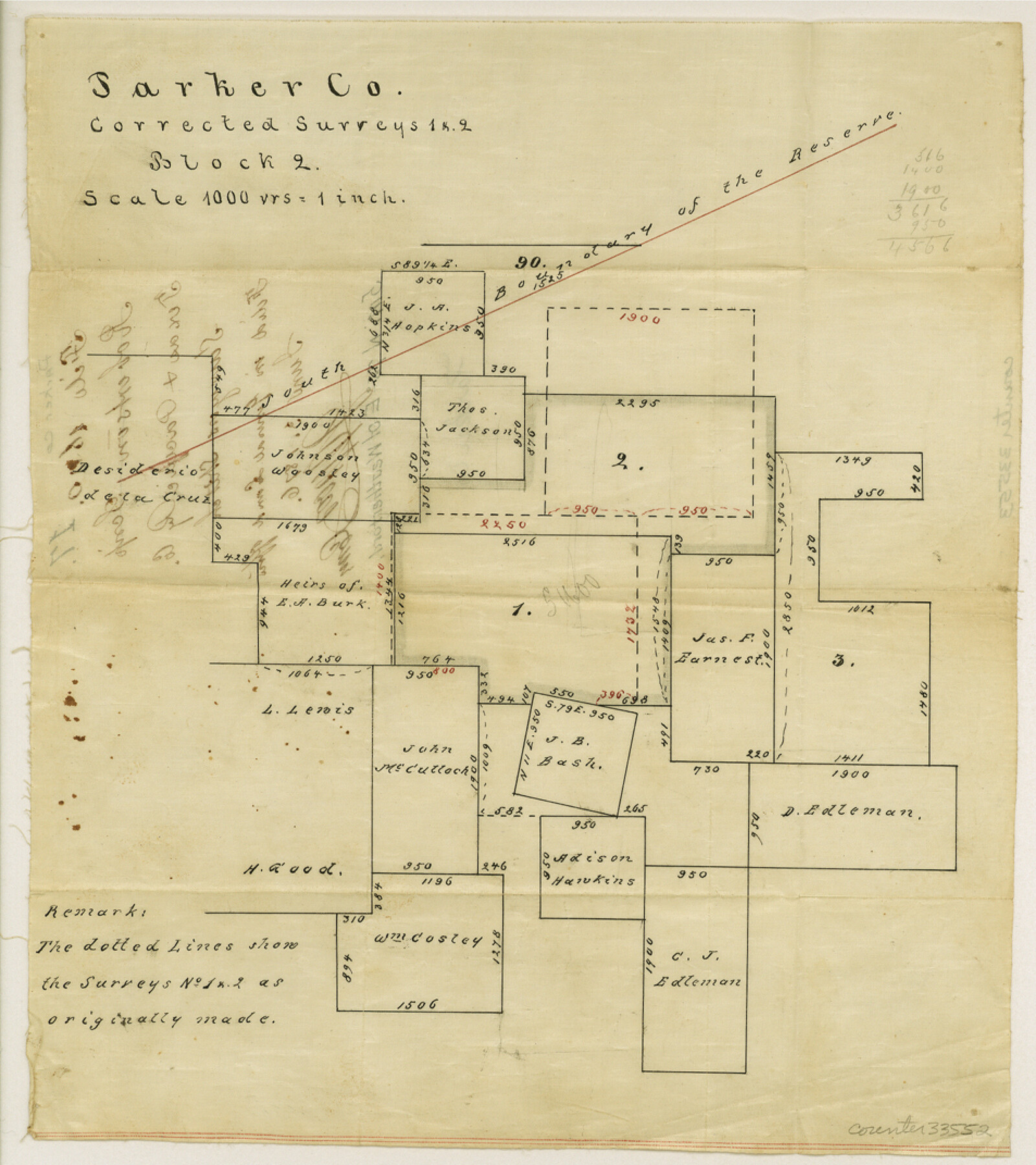
Parker County Sketch File 17
[Sketch of corrected surveys 1 and 2 in Block 2, T. & P. RR. Co.]
-
Map/Doc
33552
-
Collection
General Map Collection
-
Object Dates
6/3/1876 (File Date)
-
Counties
Parker
-
Subjects
Surveying Sketch File
-
Height x Width
10.7 x 9.5 inches
27.2 x 24.1 cm
-
Medium
paper, manuscript
-
Scale
1" = 1000 varas
Part of: General Map Collection
Nautical Chart 152-SC - Galveston Bay, Texas

Print $20.00
- Digital $50.00
Nautical Chart 152-SC - Galveston Bay, Texas
1972
Size 15.1 x 32.6 inches
Map/Doc 69892
Webb County Working Sketch 64

Print $20.00
- Digital $50.00
Webb County Working Sketch 64
1962
Size 12.8 x 26.1 inches
Map/Doc 72430
Bandera County Working Sketch 18

Print $20.00
- Digital $50.00
Bandera County Working Sketch 18
1946
Size 25.6 x 26.5 inches
Map/Doc 67614
Map of Robertson County

Print $20.00
- Digital $50.00
Map of Robertson County
1863
Size 25.6 x 20.7 inches
Map/Doc 3997
Ward County Sketch File L

Print $20.00
- Digital $50.00
Ward County Sketch File L
Size 23.8 x 29.6 inches
Map/Doc 12601
Walker County Working Sketch 4

Print $20.00
- Digital $50.00
Walker County Working Sketch 4
1934
Size 34.9 x 29.7 inches
Map/Doc 72284
Flight Mission No. CGI-4N, Frame 161, Cameron County

Print $20.00
- Digital $50.00
Flight Mission No. CGI-4N, Frame 161, Cameron County
1955
Size 18.7 x 22.4 inches
Map/Doc 84669
Potter County Sketch File 12

Print $4.00
- Digital $50.00
Potter County Sketch File 12
1890
Size 6.0 x 8.7 inches
Map/Doc 34399
Presidio County Rolled Sketch 75

Print $20.00
- Digital $50.00
Presidio County Rolled Sketch 75
1938
Size 24.8 x 20.0 inches
Map/Doc 7363
Harris County Historic Topographic 18

Print $20.00
- Digital $50.00
Harris County Historic Topographic 18
1916
Size 29.4 x 23.0 inches
Map/Doc 65828
Flight Mission No. DCL-4C, Frame 120, Kenedy County

Print $20.00
- Digital $50.00
Flight Mission No. DCL-4C, Frame 120, Kenedy County
1943
Size 18.6 x 22.5 inches
Map/Doc 85819
Blanco County Sketch File 30

Print $5.00
- Digital $50.00
Blanco County Sketch File 30
Size 9.1 x 10.6 inches
Map/Doc 14627
You may also like
Seagraves Cemetery, Gaines County, Texas

Print $20.00
- Digital $50.00
Seagraves Cemetery, Gaines County, Texas
Size 23.2 x 19.2 inches
Map/Doc 92685
St. Louis, Brownsville & Mexico Railway Location Map from Mile 120 to Rio Grande

Print $40.00
- Digital $50.00
St. Louis, Brownsville & Mexico Railway Location Map from Mile 120 to Rio Grande
1905
Size 19.6 x 67.7 inches
Map/Doc 64170
Kenedy County Rolled Sketch 10

Print $20.00
- Digital $50.00
Kenedy County Rolled Sketch 10
1915
Size 21.7 x 35.7 inches
Map/Doc 6470
Galveston County Working Sketch 8

Print $20.00
- Digital $50.00
Galveston County Working Sketch 8
1939
Size 43.4 x 39.6 inches
Map/Doc 69345
Stephens County Working Sketch Graphic Index

Print $20.00
- Digital $50.00
Stephens County Working Sketch Graphic Index
1940
Size 41.1 x 39.4 inches
Map/Doc 76702
Outer Continental Shelf Leasing Maps (Louisiana Offshore Operations)

Print $20.00
- Digital $50.00
Outer Continental Shelf Leasing Maps (Louisiana Offshore Operations)
1959
Size 17.9 x 14.0 inches
Map/Doc 76097
Armstrong County Sketch File A-13

Print $40.00
- Digital $50.00
Armstrong County Sketch File A-13
Size 12.8 x 17.7 inches
Map/Doc 13714
Pecos County Boundary File 1b

Print $8.00
- Digital $50.00
Pecos County Boundary File 1b
Size 14.2 x 8.5 inches
Map/Doc 57861
Flight Mission No. CGI-1N, Frame 177, Cameron County

Print $20.00
- Digital $50.00
Flight Mission No. CGI-1N, Frame 177, Cameron County
1955
Size 18.5 x 17.6 inches
Map/Doc 84512
Township 14 South Range 14 West, South Western District, Louisiana

Print $20.00
- Digital $50.00
Township 14 South Range 14 West, South Western District, Louisiana
1838
Size 19.5 x 24.8 inches
Map/Doc 65858
Map of Mexico, Including Yucatan & Upper California, exhibiting the Chief Cities and Towns, the Principal Travelling Routes &c.

Print $20.00
- Digital $50.00
Map of Mexico, Including Yucatan & Upper California, exhibiting the Chief Cities and Towns, the Principal Travelling Routes &c.
1847
Size 33.3 x 25.4 inches
Map/Doc 95697
