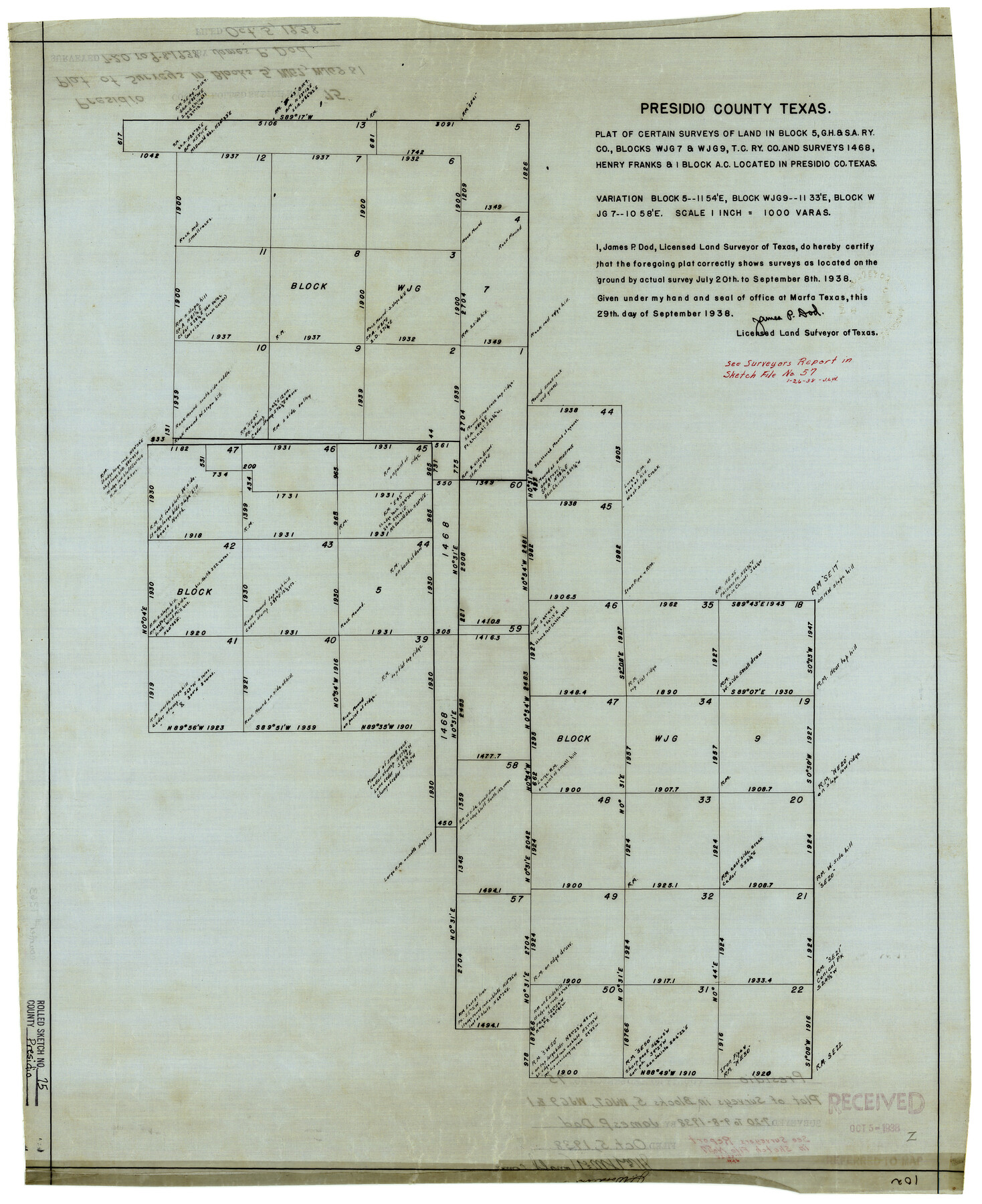
Presidio County Rolled Sketch 75
Plat of certain surveys of land in Block 5, G. H. & S. A. Ry. Co., Blocks WJG7 & WJG9, T. C. Ry. Co. and surveys 1468, Henry Franks & 1 Block A.C. located in Presidio Co., Texas
-
Map/Doc
7363
-
Collection
General Map Collection
-
Object Dates
9/29/1938 (Creation Date)
10/5/1938 (File Date)
9/8/1938 (Survey Date)
-
People and Organizations
James P. Dod (Surveyor/Engineer)
-
Counties
Presidio
-
Subjects
Surveying Rolled Sketch
-
Height x Width
24.8 x 20.0 inches
63.0 x 50.8 cm
-
Medium
linen, manuscript
-
Scale
1" = 1000 varas
-
Comments
See Presidio County Sketch File 57 (34624) for report.
Related maps
Presidio County Sketch File 57

Print $8.00
- Digital $50.00
Presidio County Sketch File 57
1938
Size 14.3 x 8.9 inches
Map/Doc 34624
Part of: General Map Collection
Baylor County Rolled Sketch BT

Print $20.00
- Digital $50.00
Baylor County Rolled Sketch BT
1916
Size 21.4 x 24.0 inches
Map/Doc 5131
Uvalde County Sketch File 8

Print $6.00
- Digital $50.00
Uvalde County Sketch File 8
1882
Size 8.4 x 6.2 inches
Map/Doc 38964
Hill County Boundary File 2

Print $18.00
- Digital $50.00
Hill County Boundary File 2
Size 10.6 x 8.1 inches
Map/Doc 54734
Cherokee County Sketch File 2

Print $6.00
- Digital $50.00
Cherokee County Sketch File 2
1857
Size 8.2 x 7.9 inches
Map/Doc 18112
Harris County NRC Article 33.136 Sketch 19

Print $50.00
- Digital $50.00
Harris County NRC Article 33.136 Sketch 19
2014
Size 24.6 x 36.6 inches
Map/Doc 95334
Irion County Rolled Sketch 20

Print $20.00
- Digital $50.00
Irion County Rolled Sketch 20
1936
Size 26.3 x 42.7 inches
Map/Doc 6329
Fort Bend County Working Sketch 18

Print $20.00
- Digital $50.00
Fort Bend County Working Sketch 18
1957
Size 34.7 x 38.2 inches
Map/Doc 69224
[Surveys along the Cibolo, Balcones and Leon Creeks]
![69728, [Surveys along the Cibolo, Balcones and Leon Creeks], General Map Collection](https://historictexasmaps.com/wmedia_w700/maps/69728-1.tif.jpg)
Print $20.00
- Digital $50.00
[Surveys along the Cibolo, Balcones and Leon Creeks]
1841
Size 14.5 x 21.0 inches
Map/Doc 69728
Map of Liberty County Texas

Print $20.00
- Digital $50.00
Map of Liberty County Texas
1895
Size 29.7 x 29.4 inches
Map/Doc 3811
Val Verde County Sketch File L

Print $26.00
- Digital $50.00
Val Verde County Sketch File L
1919
Size 12.4 x 9.1 inches
Map/Doc 39262
Sherman County Sketch File 4

Print $4.00
- Digital $50.00
Sherman County Sketch File 4
1925
Size 8.7 x 5.8 inches
Map/Doc 36688
Flight Mission No. DQN-2K, Frame 196, Calhoun County

Print $20.00
- Digital $50.00
Flight Mission No. DQN-2K, Frame 196, Calhoun County
1953
Size 16.3 x 16.1 inches
Map/Doc 84335
You may also like
Newton County Sketch File 6

Print $4.00
- Digital $50.00
Newton County Sketch File 6
1872
Size 12.4 x 7.9 inches
Map/Doc 32372
Williamson County

Print $40.00
- Digital $50.00
Williamson County
1946
Size 38.7 x 56.8 inches
Map/Doc 95676
The Republic County of Nacogdoches. February 1, 1842

Print $20.00
The Republic County of Nacogdoches. February 1, 1842
2020
Size 15.9 x 21.8 inches
Map/Doc 96247
2016 Official Travel Map, Texas

2016 Official Travel Map, Texas
Size 33.3 x 36.2 inches
Map/Doc 94297
Morris County Sketch File 2

Print $4.00
- Digital $50.00
Morris County Sketch File 2
Size 12.8 x 8.3 inches
Map/Doc 31965
Map showing lands of D. Sullivan situated in Starr County, Texas

Print $20.00
- Digital $50.00
Map showing lands of D. Sullivan situated in Starr County, Texas
Size 15.5 x 18.6 inches
Map/Doc 755
Coke County Rolled Sketch 19A

Print $20.00
- Digital $50.00
Coke County Rolled Sketch 19A
1954
Size 19.9 x 24.8 inches
Map/Doc 5520
Brazoria County Working Sketch 32

Print $20.00
- Digital $50.00
Brazoria County Working Sketch 32
1979
Size 15.8 x 36.9 inches
Map/Doc 67517
Shackelford County Boundary File 7b

Print $90.00
- Digital $50.00
Shackelford County Boundary File 7b
Size 7.9 x 10.4 inches
Map/Doc 58692
Jackson County Boundary File 1

Print $24.00
- Digital $50.00
Jackson County Boundary File 1
Size 9.0 x 3.9 inches
Map/Doc 55420
Cass County Rolled Sketch OPD

Print $20.00
- Digital $50.00
Cass County Rolled Sketch OPD
1936
Size 29.4 x 25.1 inches
Map/Doc 5483
Pecos County Working Sketch 114

Print $40.00
- Digital $50.00
Pecos County Working Sketch 114
1972
Size 75.7 x 38.0 inches
Map/Doc 71587