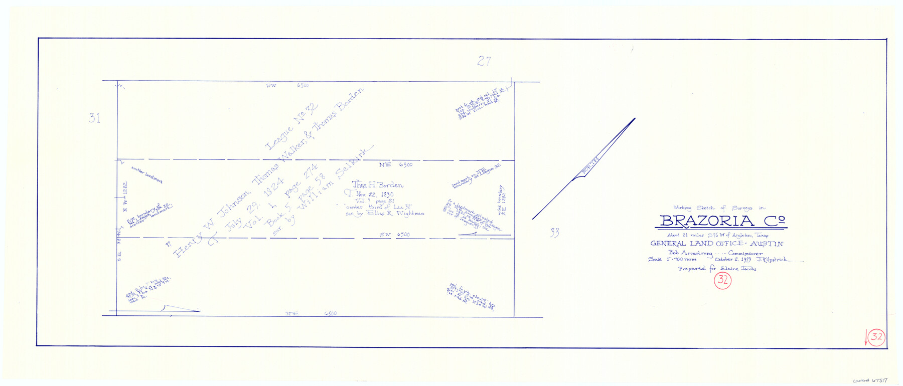
Brazoria County Working Sketch 32
-
Map/Doc
67517
-
Collection
General Map Collection
-
Object Dates
10/2/1979 (Creation Date)
-
People and Organizations
Bob Armstrong (GLO Commissioner)
Joan Kilpatrick (Draftsman)
-
Counties
Brazoria
-
Subjects
Surveying Working Sketch
-
Height x Width
15.8 x 36.9 inches
40.1 x 93.7 cm
-
Scale
1" = 400 varas
-
Comments
Surveys located about 21 miles South 76 degrees West of Angleton, Texas.
Part of: General Map Collection
Map of the Missouri Pacific Railway, St. Louis, Iron Mountain and Southern R'y

Print $20.00
- Digital $50.00
Map of the Missouri Pacific Railway, St. Louis, Iron Mountain and Southern R'y
1894
Size 11.4 x 17.5 inches
Map/Doc 93950
Wilson County Working Sketch 12

Print $20.00
- Digital $50.00
Wilson County Working Sketch 12
1981
Size 19.5 x 12.9 inches
Map/Doc 72592
Duval County Working Sketch 9
Print $20.00
- Digital $50.00
Duval County Working Sketch 9
1935
Size 25.8 x 29.1 inches
Map/Doc 68722
Hays County Working Sketch 4

Print $20.00
- Digital $50.00
Hays County Working Sketch 4
1928
Size 25.4 x 21.7 inches
Map/Doc 66078
McMullen County Sketch File 13

Print $4.00
- Digital $50.00
McMullen County Sketch File 13
1876
Size 10.0 x 8.0 inches
Map/Doc 31359
Hood County Working Sketch 24

Print $20.00
- Digital $50.00
Hood County Working Sketch 24
1993
Size 36.2 x 37.4 inches
Map/Doc 66218
Webb County Working Sketch 44

Print $20.00
- Digital $50.00
Webb County Working Sketch 44
1943
Size 26.0 x 27.4 inches
Map/Doc 72409
Irion County Working Sketch 13

Print $40.00
- Digital $50.00
Irion County Working Sketch 13
1968
Size 88.1 x 31.6 inches
Map/Doc 66422
Montgomery County Rolled Sketch 12

Print $20.00
- Digital $50.00
Montgomery County Rolled Sketch 12
Size 23.4 x 30.5 inches
Map/Doc 6801
Stonewall County Sketch File AA1

Print $26.00
- Digital $50.00
Stonewall County Sketch File AA1
1916
Size 14.3 x 8.6 inches
Map/Doc 37288
Reagan County Rolled Sketch 17

Print $20.00
- Digital $50.00
Reagan County Rolled Sketch 17
Size 33.9 x 32.6 inches
Map/Doc 10623
Pecos County Working Sketch 17

Print $20.00
- Digital $50.00
Pecos County Working Sketch 17
1915
Size 32.5 x 23.0 inches
Map/Doc 71487
You may also like

[H. & G. N. Block 8 showing Llano and Espuella fence lines]
![90375, [H. & G. N. Block 8 showing Llano and Espuella fence lines], Twichell Survey Records](https://historictexasmaps.com/wmedia_w700/maps/90375-1.tif.jpg)
Print $2.00
- Digital $50.00
[H. & G. N. Block 8 showing Llano and Espuella fence lines]
Size 8.7 x 11.0 inches
Map/Doc 90375
Denison, Grayson County, Texas, 1891

Print $20.00
Denison, Grayson County, Texas, 1891
1891
Size 23.9 x 36.4 inches
Map/Doc 93480
Calhoun County Rolled Sketch 6

Print $20.00
- Digital $50.00
Calhoun County Rolled Sketch 6
Size 24.0 x 22.5 inches
Map/Doc 5362
Flight Mission No. DQO-3K, Frame 38, Galveston County

Print $20.00
- Digital $50.00
Flight Mission No. DQO-3K, Frame 38, Galveston County
1952
Size 18.7 x 22.3 inches
Map/Doc 85079
[Map of Matagorda County Showing Abandoned Surveys]
![2066, [Map of Matagorda County Showing Abandoned Surveys], General Map Collection](https://historictexasmaps.com/wmedia_w700/maps/2066.tif.jpg)
Print $40.00
- Digital $50.00
[Map of Matagorda County Showing Abandoned Surveys]
1920
Size 50.3 x 40.2 inches
Map/Doc 2066
[Texas and Pacific Railroad Co. Blocks 55, 54 and 76, Townships 1 & 2]
![89882, [Texas and Pacific Railroad Co. Blocks 55, 54 and 76, Townships 1 & 2], Twichell Survey Records](https://historictexasmaps.com/wmedia_w700/maps/89882-1.tif.jpg)
Print $20.00
- Digital $50.00
[Texas and Pacific Railroad Co. Blocks 55, 54 and 76, Townships 1 & 2]
Size 46.2 x 41.5 inches
Map/Doc 89882
El Paso County Rolled Sketch VD

Print $40.00
- Digital $50.00
El Paso County Rolled Sketch VD
1915
Size 18.4 x 67.4 inches
Map/Doc 8862
Johnson County Working Sketch 11

Print $20.00
- Digital $50.00
Johnson County Working Sketch 11
1953
Size 28.7 x 22.4 inches
Map/Doc 66624
San Luis Pass to Matagorda Bay

Print $20.00
- Digital $50.00
San Luis Pass to Matagorda Bay
1933
Size 34.3 x 47.3 inches
Map/Doc 69960
Flight Mission No. CUG-1P, Frame 166, Kleberg County

Print $20.00
- Digital $50.00
Flight Mission No. CUG-1P, Frame 166, Kleberg County
1956
Size 18.8 x 22.4 inches
Map/Doc 86173
Edwards County Boundary File 27b

Print $18.00
- Digital $50.00
Edwards County Boundary File 27b
Size 4.1 x 11.6 inches
Map/Doc 52887