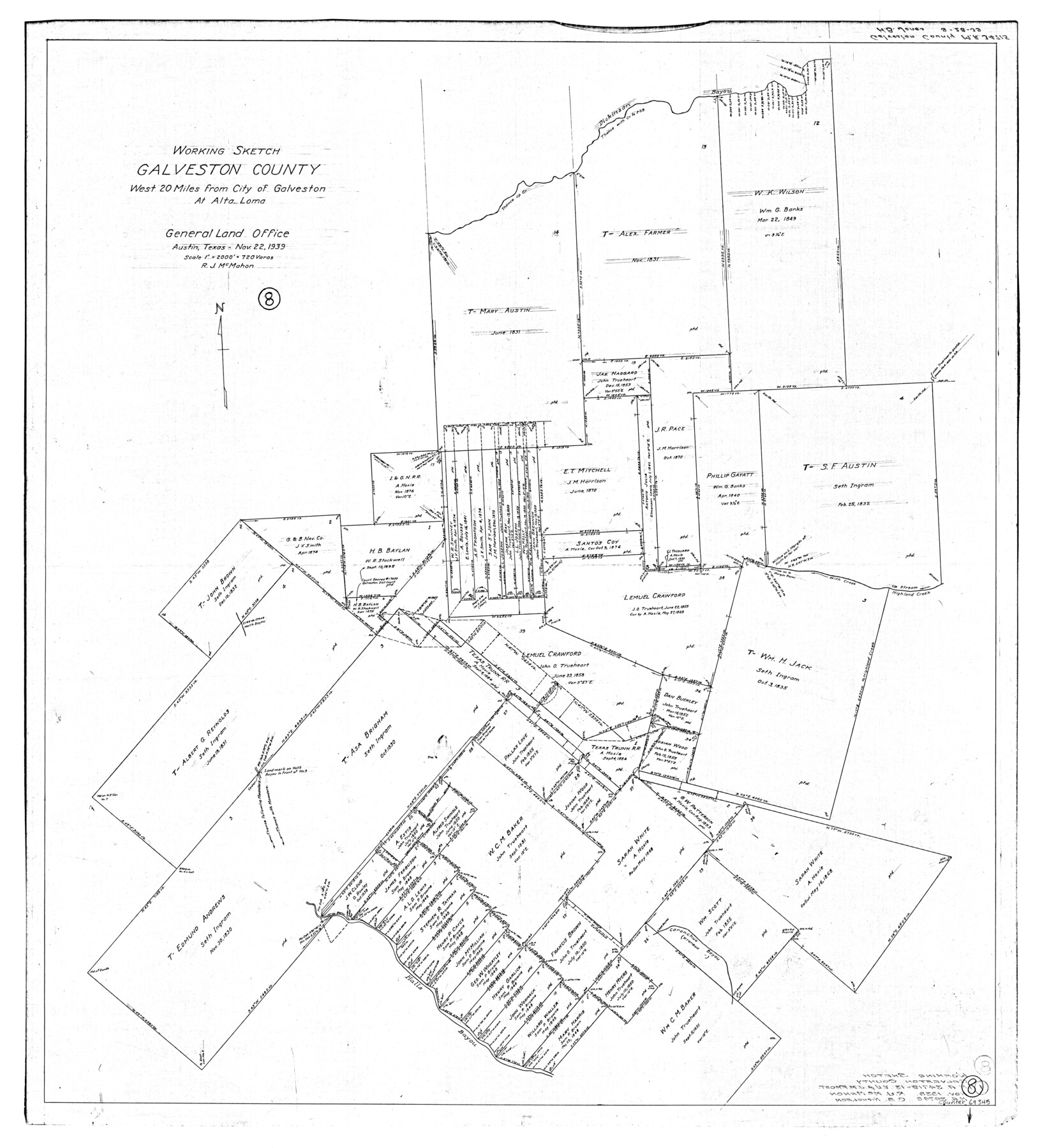
Galveston County Working Sketch 8
-
Map/Doc
69345
-
Collection
General Map Collection
-
Object Dates
11/22/1939 (Creation Date)
-
People and Organizations
R.J. McMahon (Draftsman)
-
Counties
Galveston
-
Subjects
Surveying Working Sketch
-
Height x Width
43.4 x 39.6 inches
110.2 x 100.6 cm
-
Scale
1" = 720 varas
Part of: General Map Collection
Part of Laguna Madre in Nueces and Kleberg Counties, showing Subdivision for Mineral Development

Print $20.00
- Digital $50.00
Part of Laguna Madre in Nueces and Kleberg Counties, showing Subdivision for Mineral Development
1948
Size 42.0 x 30.3 inches
Map/Doc 1921
Clay County Boundary File 1

Print $10.00
- Digital $50.00
Clay County Boundary File 1
Size 8.8 x 11.2 inches
Map/Doc 51356
Houston including Bellaire, Bunker Hill, Galena Park, Hedwig, Hilshire, Hunters Creek, Jacinto City, Jersey Village, Missouri City, Pasadena, Piney Point, South Houston, Spring Valley, West University Place and adjoining communities [Verso]
![94180, Houston including Bellaire, Bunker Hill, Galena Park, Hedwig, Hilshire, Hunters Creek, Jacinto City, Jersey Village, Missouri City, Pasadena, Piney Point, South Houston, Spring Valley, West University Place and adjoining communities [Verso], General Map Collection](https://historictexasmaps.com/wmedia_w700/maps/94180.tif.jpg)
Houston including Bellaire, Bunker Hill, Galena Park, Hedwig, Hilshire, Hunters Creek, Jacinto City, Jersey Village, Missouri City, Pasadena, Piney Point, South Houston, Spring Valley, West University Place and adjoining communities [Verso]
Size 27.1 x 42.4 inches
Map/Doc 94180
Right of Way and Track Map Texas & New Orleans R.R. Co. operated by the T. & N. O. R.R. Co. Dallas-Sabine Branch

Print $40.00
- Digital $50.00
Right of Way and Track Map Texas & New Orleans R.R. Co. operated by the T. & N. O. R.R. Co. Dallas-Sabine Branch
1918
Size 26.1 x 57.1 inches
Map/Doc 64153
Tarrant County State Real Property Sketch 2

Print $20.00
- Digital $50.00
Tarrant County State Real Property Sketch 2
1994
Size 21.3 x 27.6 inches
Map/Doc 61668
Flight Mission No. BRA-7M, Frame 26, Jefferson County

Print $20.00
- Digital $50.00
Flight Mission No. BRA-7M, Frame 26, Jefferson County
1953
Size 18.4 x 22.2 inches
Map/Doc 85477
Intracoastal Waterway in Texas - Corpus Christi to Point Isabel including Arroyo Colorado to Mo. Pac. R.R. Bridge Near Harlingen

Print $20.00
- Digital $50.00
Intracoastal Waterway in Texas - Corpus Christi to Point Isabel including Arroyo Colorado to Mo. Pac. R.R. Bridge Near Harlingen
1934
Size 22.0 x 32.7 inches
Map/Doc 61880
Grayson County Sketch File 22

Print $4.00
- Digital $50.00
Grayson County Sketch File 22
1871
Size 10.4 x 8.4 inches
Map/Doc 24501
Anderson County Sketch File 4

Print $6.00
- Digital $50.00
Anderson County Sketch File 4
Size 8.7 x 6.4 inches
Map/Doc 12743
Leon County Sketch File 3

Print $4.00
- Digital $50.00
Leon County Sketch File 3
Size 12.4 x 7.9 inches
Map/Doc 29713
Shelby County Sketch File 11

Print $50.00
- Digital $50.00
Shelby County Sketch File 11
1859
Size 8.8 x 7.0 inches
Map/Doc 36613
Swisher County

Print $20.00
- Digital $50.00
Swisher County
1879
Size 20.9 x 18.7 inches
Map/Doc 4063
You may also like
Flight Mission No. DQO-1K, Frame 154, Galveston County

Print $20.00
- Digital $50.00
Flight Mission No. DQO-1K, Frame 154, Galveston County
1952
Size 18.8 x 22.5 inches
Map/Doc 85007
Glasscock County Sketch File 1

Print $46.00
- Digital $50.00
Glasscock County Sketch File 1
Size 26.1 x 31.8 inches
Map/Doc 11558
Schleicher County Working Sketch 9

Print $20.00
- Digital $50.00
Schleicher County Working Sketch 9
1923
Size 12.4 x 11.8 inches
Map/Doc 63811
Capitol Lands Surveyed by J. T. Munson

Print $20.00
- Digital $50.00
Capitol Lands Surveyed by J. T. Munson
Size 14.3 x 13.0 inches
Map/Doc 90511
[Mary Fury and B. H. Epperson surveys]
![93066, [Mary Fury and B. H. Epperson surveys], Twichell Survey Records](https://historictexasmaps.com/wmedia_w700/maps/93066-1.tif.jpg)
Print $3.00
- Digital $50.00
[Mary Fury and B. H. Epperson surveys]
1919
Size 10.6 x 14.6 inches
Map/Doc 93066
Coleman County Sketch File 37

Print $4.00
- Digital $50.00
Coleman County Sketch File 37
1891
Size 11.1 x 8.4 inches
Map/Doc 18742
San Patricio County Sketch File 4

Print $40.00
- Digital $50.00
San Patricio County Sketch File 4
Size 16.9 x 30.5 inches
Map/Doc 12283
[Gulf, Colorado & Santa Fe]
![64590, [Gulf, Colorado & Santa Fe], General Map Collection](https://historictexasmaps.com/wmedia_w700/maps/64590.tif.jpg)
Print $40.00
- Digital $50.00
[Gulf, Colorado & Santa Fe]
1918
Size 31.4 x 117.0 inches
Map/Doc 64590
Sherman County Rolled Sketch 12

Print $40.00
- Digital $50.00
Sherman County Rolled Sketch 12
1951
Size 63.9 x 11.3 inches
Map/Doc 10611
[Caddo Lake Area]
![91389, [Caddo Lake Area], Twichell Survey Records](https://historictexasmaps.com/wmedia_w700/maps/91389-1.tif.jpg)
Print $20.00
- Digital $50.00
[Caddo Lake Area]
1918
Size 28.4 x 35.3 inches
Map/Doc 91389
Map of Young County

Print $20.00
- Digital $50.00
Map of Young County
1880
Size 22.0 x 20.3 inches
Map/Doc 4174
Runnels County Rolled Sketch 40

Print $20.00
- Digital $50.00
Runnels County Rolled Sketch 40
Size 33.5 x 40.9 inches
Map/Doc 7527