Tarrant County State Real Property Sketch 2
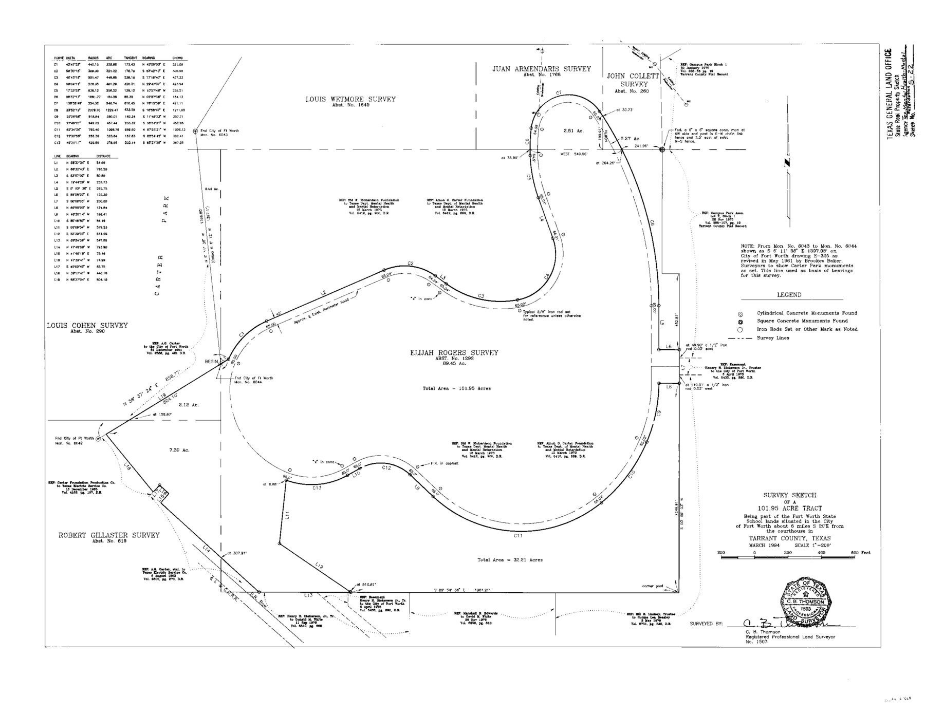
A Survey Sketch of a 101.95 Acre Tract Being Part of the Fort Worth State School Lands
State Real Property Sketch S - 22
-
Map/Doc
61668
-
Collection
General Map Collection
-
Object Dates
1994 (Creation Date)
-
People and Organizations
Texas General Land Office (Publisher)
Texas General Land Office (Printer)
Garry Mauro (GLO Commissioner)
C.B. Thomson (Surveyor/Engineer)
-
Counties
Tarrant
-
Subjects
State Real Property
-
Height x Width
21.3 x 27.6 inches
54.1 x 70.1 cm
-
Comments
Plat of the Fort Worth State School lands situated in the City of Fort Worth located about 6 miles South 20 degrees East from the courthouse.
Part of: General Map Collection
[Surveys in Austin's Colony along the Brazos River]
![164, [Surveys in Austin's Colony along the Brazos River], General Map Collection](https://historictexasmaps.com/wmedia_w700/maps/164.tif.jpg)
Print $20.00
- Digital $50.00
[Surveys in Austin's Colony along the Brazos River]
1833
Size 25.0 x 23.9 inches
Map/Doc 164
Brazoria County Sketch File 7

Print $4.00
- Digital $50.00
Brazoria County Sketch File 7
1868
Size 8.6 x 11.0 inches
Map/Doc 14932
Flight Mission No. DQN-2K, Frame 164, Calhoun County

Print $20.00
- Digital $50.00
Flight Mission No. DQN-2K, Frame 164, Calhoun County
1953
Size 18.7 x 22.5 inches
Map/Doc 84326
United States - Gulf Coast Texas - Southern part of Laguna Madre

Print $20.00
- Digital $50.00
United States - Gulf Coast Texas - Southern part of Laguna Madre
1933
Size 27.1 x 18.3 inches
Map/Doc 72950
Crane County Rolled Sketch 5A

Print $20.00
- Digital $50.00
Crane County Rolled Sketch 5A
1927
Size 38.0 x 46.4 inches
Map/Doc 8678
Webb County Working Sketch 67

Print $40.00
- Digital $50.00
Webb County Working Sketch 67
1966
Size 60.9 x 43.7 inches
Map/Doc 72434
Cherokee County Working Sketch 4

Print $20.00
- Digital $50.00
Cherokee County Working Sketch 4
1950
Size 33.1 x 31.5 inches
Map/Doc 67959
McLennan County Working Sketch 4

Print $20.00
- Digital $50.00
McLennan County Working Sketch 4
1941
Size 19.2 x 27.9 inches
Map/Doc 70697
Edwards County Working Sketch 25

Print $20.00
- Digital $50.00
Edwards County Working Sketch 25
1942
Size 22.6 x 20.8 inches
Map/Doc 68901
Midland County Working Sketch 22

Print $40.00
- Digital $50.00
Midland County Working Sketch 22
1956
Size 97.0 x 43.1 inches
Map/Doc 71003
Lampasas County Boundary File 1

Print $4.00
- Digital $50.00
Lampasas County Boundary File 1
Size 10.2 x 8.2 inches
Map/Doc 56093
Flight Mission No. BRA-6M, Frame 85, Jefferson County

Print $20.00
- Digital $50.00
Flight Mission No. BRA-6M, Frame 85, Jefferson County
1953
Size 18.6 x 22.4 inches
Map/Doc 85429
You may also like
Trinity County Sketch File 14

Print $4.00
- Digital $50.00
Trinity County Sketch File 14
1862
Size 8.7 x 12.0 inches
Map/Doc 38540
Hale County Sketch File 5-5a

Print $30.00
- Digital $50.00
Hale County Sketch File 5-5a
1891
Size 17.7 x 38.3 inches
Map/Doc 10467
Crane County Rolled Sketch 19

Print $20.00
- Digital $50.00
Crane County Rolled Sketch 19
1926
Size 26.4 x 28.3 inches
Map/Doc 5577
El Paso County

Print $40.00
- Digital $50.00
El Paso County
1881
Size 52.0 x 36.8 inches
Map/Doc 89059
Bee County Working Sketch Graphic Index

Print $20.00
- Digital $50.00
Bee County Working Sketch Graphic Index
1950
Size 41.6 x 45.4 inches
Map/Doc 76464
Flight Mission No. BRA-7M, Frame 24, Jefferson County

Print $20.00
- Digital $50.00
Flight Mission No. BRA-7M, Frame 24, Jefferson County
1953
Size 18.6 x 22.3 inches
Map/Doc 85475
Flight Mission No. CUG-2P, Frame 69, Kleberg County

Print $20.00
- Digital $50.00
Flight Mission No. CUG-2P, Frame 69, Kleberg County
1956
Size 18.4 x 22.2 inches
Map/Doc 86206
Hays County Sketch File 7

Print $4.00
- Digital $50.00
Hays County Sketch File 7
1858
Size 8.4 x 12.9 inches
Map/Doc 26208
Upshur County Rolled Sketch 6

Print $20.00
- Digital $50.00
Upshur County Rolled Sketch 6
2003
Size 37.0 x 25.1 inches
Map/Doc 81941
Flight Mission No. DQN-6K, Frame 71, Calhoun County

Print $20.00
- Digital $50.00
Flight Mission No. DQN-6K, Frame 71, Calhoun County
1953
Size 18.5 x 22.2 inches
Map/Doc 84443
Van Zandt County Working Sketch 1

Print $20.00
- Digital $50.00
Van Zandt County Working Sketch 1
1946
Size 23.7 x 30.0 inches
Map/Doc 72250
Red River County Sketch File 6

Print $8.00
- Digital $50.00
Red River County Sketch File 6
1853
Size 10.4 x 6.9 inches
Map/Doc 35105