Red River County Sketch File 6
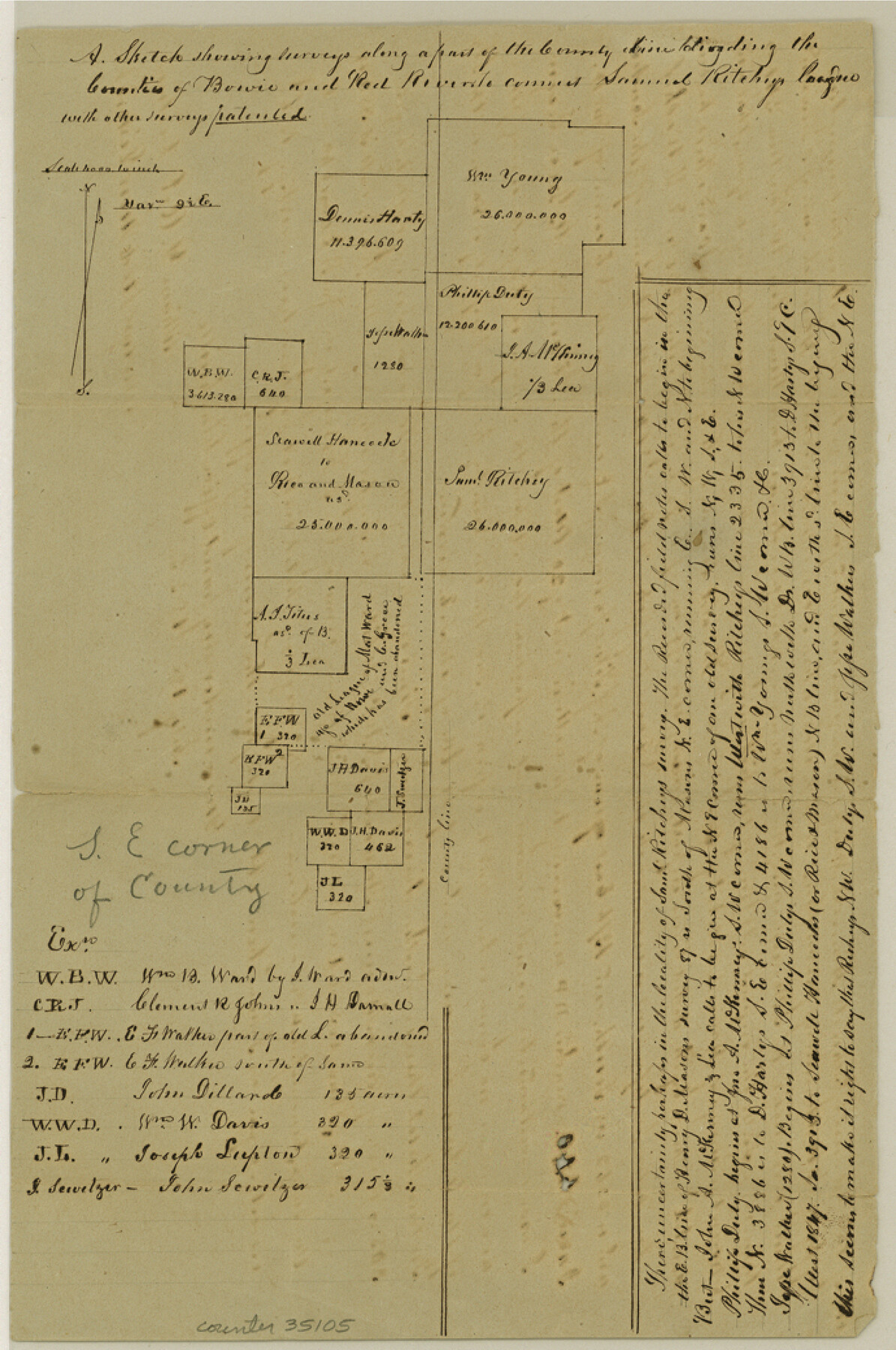
[Sketches showing surveys along a part of the Red River-Bowie county line in the southeast part of Red River County]
-
Map/Doc
35105
-
Collection
General Map Collection
-
Object Dates
5/21/1853 (Creation Date)
10/31/1853 (File Date)
-
People and Organizations
William D. Orr (Surveyor/Engineer)
-
Counties
Red River Bowie
-
Subjects
Surveying Sketch File
-
Height x Width
10.4 x 6.9 inches
26.4 x 17.5 cm
-
Medium
paper, manuscript
Part of: General Map Collection
Map of Sabine County

Print $20.00
- Digital $50.00
Map of Sabine County
1896
Size 26.6 x 19.3 inches
Map/Doc 4010
Flight Mission No. DAG-23K, Frame 146, Matagorda County

Print $20.00
- Digital $50.00
Flight Mission No. DAG-23K, Frame 146, Matagorda County
1953
Size 17.0 x 22.4 inches
Map/Doc 86494
Brewster County Sketch File NS-4g

Print $4.00
- Digital $50.00
Brewster County Sketch File NS-4g
1930
Size 10.5 x 7.2 inches
Map/Doc 15981
Map of Zavalla County

Print $20.00
- Digital $50.00
Map of Zavalla County
1862
Size 24.2 x 20.5 inches
Map/Doc 4180
Map of Jack County

Print $20.00
- Digital $50.00
Map of Jack County
1896
Size 22.7 x 27.4 inches
Map/Doc 4571
Travis County Sketch File 40

Print $20.00
- Digital $50.00
Travis County Sketch File 40
1928
Size 17.7 x 22.8 inches
Map/Doc 12464
Flight Mission No. DCL-7C, Frame 9, Kenedy County

Print $20.00
- Digital $50.00
Flight Mission No. DCL-7C, Frame 9, Kenedy County
1943
Size 15.3 x 15.2 inches
Map/Doc 86001
Taylor County Rolled Sketch 30A

Print $20.00
- Digital $50.00
Taylor County Rolled Sketch 30A
Size 17.5 x 11.3 inches
Map/Doc 76410
Packery Channel

Print $20.00
- Digital $50.00
Packery Channel
1930
Size 26.6 x 37.1 inches
Map/Doc 2990
Somervell County Working Sketch 4

Print $20.00
- Digital $50.00
Somervell County Working Sketch 4
1975
Size 38.3 x 29.7 inches
Map/Doc 63908
Fayette County

Print $40.00
- Digital $50.00
Fayette County
1978
Size 42.8 x 54.5 inches
Map/Doc 77278
Harris County Sketch File 64

Print $40.00
- Digital $50.00
Harris County Sketch File 64
Size 16.3 x 14.1 inches
Map/Doc 25503
You may also like
Harris County Sketch File 24

Print $8.00
- Digital $50.00
Harris County Sketch File 24
Size 8.8 x 8.0 inches
Map/Doc 25385
Crane County Sketch File 21

Print $7.00
- Digital $50.00
Crane County Sketch File 21
1930
Size 11.4 x 8.9 inches
Map/Doc 19590
Presidio County Sketch File 92

Print $10.00
- Digital $50.00
Presidio County Sketch File 92
1958
Size 11.2 x 8.8 inches
Map/Doc 34765
Upton County Working Sketch 29

Print $40.00
- Digital $50.00
Upton County Working Sketch 29
1956
Size 50.6 x 36.0 inches
Map/Doc 69525
Map of Dallas County

Print $20.00
- Digital $50.00
Map of Dallas County
Size 22.2 x 18.5 inches
Map/Doc 3464
Fisher County Working Sketch 13

Print $20.00
- Digital $50.00
Fisher County Working Sketch 13
1956
Size 29.8 x 32.7 inches
Map/Doc 69147
Map of Hamilton County

Print $20.00
- Digital $50.00
Map of Hamilton County
1872
Size 15.0 x 21.9 inches
Map/Doc 4557
Flight Mission No. BRE-1P, Frame 6, Nueces County

Print $20.00
- Digital $50.00
Flight Mission No. BRE-1P, Frame 6, Nueces County
1956
Size 18.2 x 22.1 inches
Map/Doc 86614
Terrell County Working Sketch 79

Print $40.00
- Digital $50.00
Terrell County Working Sketch 79
1983
Size 43.0 x 55.8 inches
Map/Doc 69600
Lynn County Sketch File 11

Print $4.00
- Digital $50.00
Lynn County Sketch File 11
1906
Size 14.2 x 8.6 inches
Map/Doc 30478

Hill County Sketch file 28

Print $33.00
- Digital $50.00
Hill County Sketch file 28
1987
Size 11.3 x 8.9 inches
Map/Doc 26530