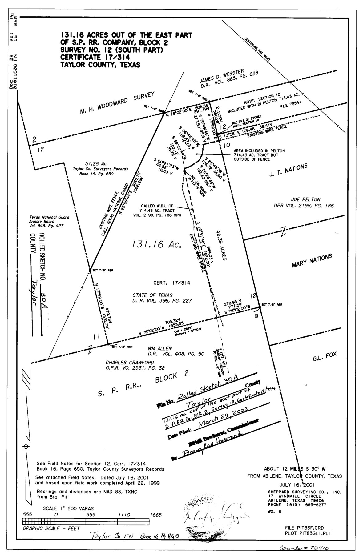
Taylor County Rolled Sketch 30A
131.16 acres out of the east part of S. P. R.R. Company, Block 2, survey no. 12 (south part), certificate 17/314, Taylor County, Texas
-
Map/Doc
76410
-
Collection
General Map Collection
-
Object Dates
1999/4/22 (Survey Date)
2002/3/29 (File Date)
-
People and Organizations
Maxey Sheppard (Surveyor/Engineer)
-
Counties
Taylor
-
Subjects
Surveying Rolled Sketch
-
Height x Width
17.5 x 11.3 inches
44.5 x 28.7 cm
-
Medium
mylar, print
-
Scale
1" = 200 varas
Part of: General Map Collection
State of Texas, Plate 1: Surface-Water Development, Exisiting Reservoirs and Reservoir Sites

Print $20.00
- Digital $50.00
State of Texas, Plate 1: Surface-Water Development, Exisiting Reservoirs and Reservoir Sites
1984
Size 17.8 x 18.1 inches
Map/Doc 3128
Coast of Texas from Vicinity of Bolivar Point to Rollover Station

Print $40.00
- Digital $50.00
Coast of Texas from Vicinity of Bolivar Point to Rollover Station
1886
Size 32.5 x 54.0 inches
Map/Doc 69920
Red River County Working Sketch 10

Print $20.00
- Digital $50.00
Red River County Working Sketch 10
1920
Size 19.1 x 18.8 inches
Map/Doc 71993
Mason County Rolled Sketch 8

Print $20.00
- Digital $50.00
Mason County Rolled Sketch 8
2010
Size 18.5 x 24.4 inches
Map/Doc 89283
Polk County Rolled Sketch 20

Print $20.00
- Digital $50.00
Polk County Rolled Sketch 20
Size 30.8 x 22.9 inches
Map/Doc 7312
Crockett County Working Sketch 64

Print $20.00
- Digital $50.00
Crockett County Working Sketch 64
1957
Size 19.0 x 25.4 inches
Map/Doc 68397
Parmer County

Print $20.00
- Digital $50.00
Parmer County
1926
Size 46.2 x 36.5 inches
Map/Doc 66973
Val Verde County Working Sketch 18

Print $20.00
- Digital $50.00
Val Verde County Working Sketch 18
1928
Size 31.4 x 28.3 inches
Map/Doc 72153
Andrews County

Print $40.00
- Digital $50.00
Andrews County
1901
Size 35.9 x 49.7 inches
Map/Doc 4872
Uvalde County Working Sketch 18

Print $20.00
- Digital $50.00
Uvalde County Working Sketch 18
1948
Size 33.0 x 26.5 inches
Map/Doc 72088
Val Verde County Sketch File Z2

Print $31.00
- Digital $50.00
Val Verde County Sketch File Z2
1881
Size 16.7 x 10.7 inches
Map/Doc 39114
Denton County Sketch File 35

Print $14.00
- Digital $50.00
Denton County Sketch File 35
1897
Size 9.5 x 8.8 inches
Map/Doc 20766
You may also like
Flight Mission No. CUG-3P, Frame 93, Kleberg County

Print $20.00
- Digital $50.00
Flight Mission No. CUG-3P, Frame 93, Kleberg County
1956
Size 18.5 x 22.2 inches
Map/Doc 86263
Erath County Working Sketch 51

Print $20.00
- Digital $50.00
Erath County Working Sketch 51
1986
Size 38.3 x 45.6 inches
Map/Doc 69133
King County Sketch File 7A

Print $28.00
- Digital $50.00
King County Sketch File 7A
1902
Size 22.1 x 34.7 inches
Map/Doc 11936
Wilbarger County Sketch File 9

Print $4.00
- Digital $50.00
Wilbarger County Sketch File 9
1885
Size 12.7 x 8.2 inches
Map/Doc 40181

Wichita County Boundary File 5

Print $20.00
- Digital $50.00
Wichita County Boundary File 5
Size 11.0 x 38.5 inches
Map/Doc 59915
Childress County Rolled Sketch 8A

Print $20.00
- Digital $50.00
Childress County Rolled Sketch 8A
Size 18.2 x 12.9 inches
Map/Doc 5443
Duval County Rolled Sketch 35

Print $20.00
- Digital $50.00
Duval County Rolled Sketch 35
1951
Size 23.5 x 17.0 inches
Map/Doc 5750
Lubbock County Working Sketch 5

Print $20.00
- Digital $50.00
Lubbock County Working Sketch 5
1950
Size 14.3 x 31.0 inches
Map/Doc 70665
Map of Hale County

Print $40.00
- Digital $50.00
Map of Hale County
1900
Size 49.3 x 41.0 inches
Map/Doc 4691
Hardeman County Sketch File 15

Print $20.00
- Digital $50.00
Hardeman County Sketch File 15
Size 18.9 x 17.9 inches
Map/Doc 11627
Tyler County Sketch File 7a

Print $7.00
- Digital $50.00
Tyler County Sketch File 7a
1874
Size 10.3 x 8.1 inches
Map/Doc 38639