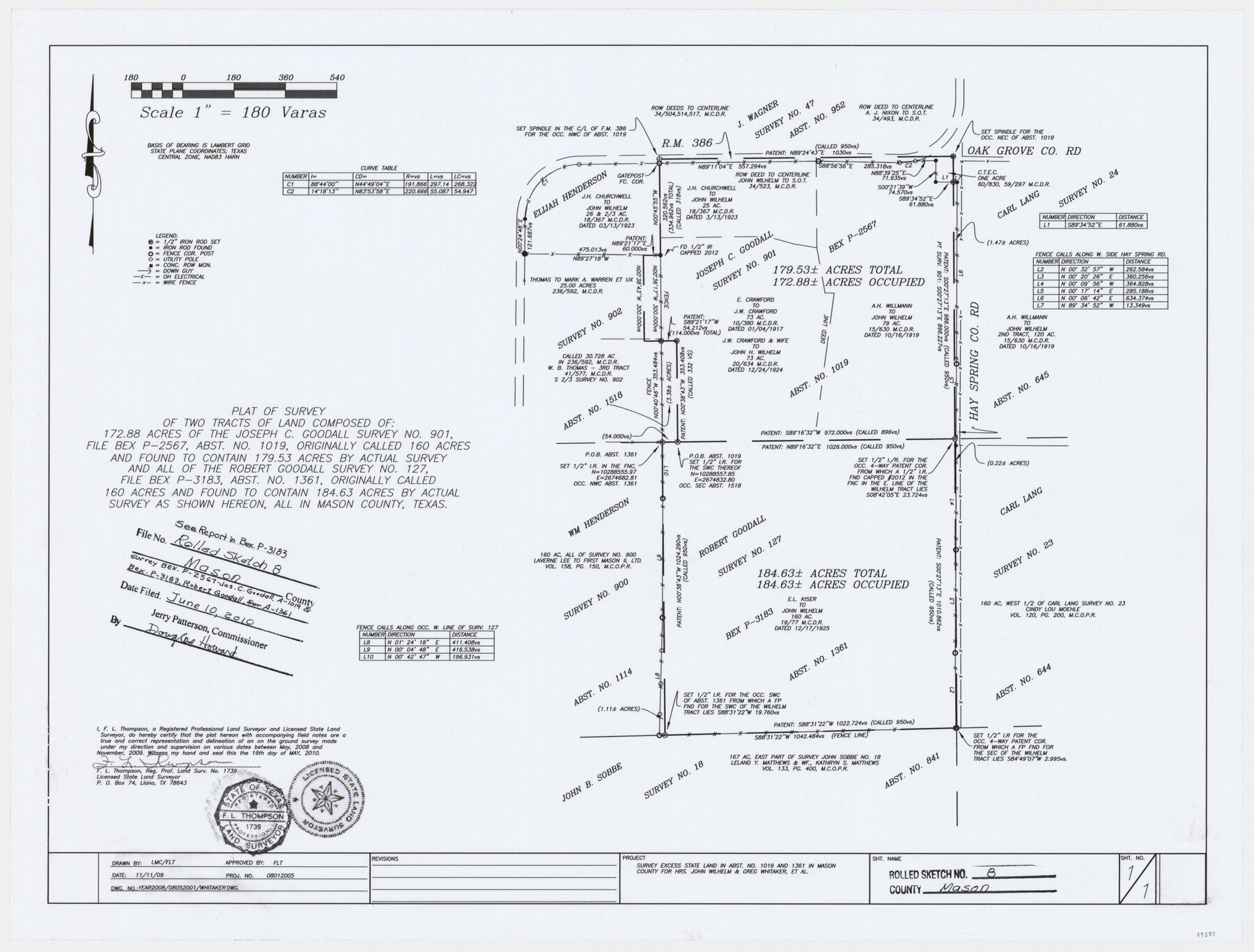
Mason County Rolled Sketch 8
[Plat of Joseph C. Goodall survey no. 901, abst. 1019, Robert Goodall survey no. 127, abst. 1361, and surrounding surveys, Mason County, Texas]
-
Map/Doc
89283
-
Collection
General Map Collection
-
Object Dates
2010/5/19 (Creation Date)
2010/6/10 (File Date)
-
People and Organizations
F.L. Thompson (Surveyor/Engineer)
-
Counties
Mason
-
Subjects
Surveying Rolled Sketch
-
Height x Width
18.5 x 24.4 inches
47.0 x 62.0 cm
-
Medium
mylar, print
-
Scale
1" = 180 varas
-
Comments
See report in BEX P-3183.
Part of: General Map Collection
San Patricio County Rolled Sketch 45

Print $20.00
- Digital $50.00
San Patricio County Rolled Sketch 45
1979
Size 24.0 x 33.5 inches
Map/Doc 7729
Flight Mission No. BRA-6M, Frame 76, Jefferson County

Print $20.00
- Digital $50.00
Flight Mission No. BRA-6M, Frame 76, Jefferson County
1953
Size 18.6 x 22.4 inches
Map/Doc 85420
Map of San Jacinto County

Print $20.00
- Digital $50.00
Map of San Jacinto County
1872
Size 22.0 x 18.6 inches
Map/Doc 1346

Travis County

Print $40.00
- Digital $50.00
Travis County
1936
Size 45.6 x 55.8 inches
Map/Doc 63077
Bee County Working Sketch 19

Print $20.00
- Digital $50.00
Bee County Working Sketch 19
1980
Size 17.3 x 11.9 inches
Map/Doc 67269
Nueces County Sketch File 68

Print $8.00
- Digital $50.00
Nueces County Sketch File 68
Size 11.0 x 8.7 inches
Map/Doc 33000
Grayson County Working Sketch 11

Print $20.00
- Digital $50.00
Grayson County Working Sketch 11
1951
Size 27.9 x 24.3 inches
Map/Doc 63250
Hutchinson County Working Sketch 6

Print $20.00
- Digital $50.00
Hutchinson County Working Sketch 6
1914
Size 20.2 x 29.0 inches
Map/Doc 66364
Harris County State Real Property Sketch 3

Print $42.00
- Digital $50.00
Harris County State Real Property Sketch 3
2004
Size 24.9 x 36.9 inches
Map/Doc 81952
Knox County Rolled Sketch 15

Print $40.00
- Digital $50.00
Knox County Rolled Sketch 15
1892
Size 21.9 x 54.8 inches
Map/Doc 10667
Harris County Sketch File E

Print $4.00
- Digital $50.00
Harris County Sketch File E
1860
Size 7.6 x 12.1 inches
Map/Doc 25315
You may also like
Gulf Oil Corp. Fishgide - Freeport

Gulf Oil Corp. Fishgide - Freeport
1960
Size 12.3 x 22.4 inches
Map/Doc 75978
Jasper County Sketch File 7

Print $22.00
- Digital $50.00
Jasper County Sketch File 7
Size 12.4 x 15.4 inches
Map/Doc 27775
Flight Mission No. CRE-2R, Frame 153, Jackson County

Print $20.00
- Digital $50.00
Flight Mission No. CRE-2R, Frame 153, Jackson County
1956
Size 18.7 x 22.3 inches
Map/Doc 85364
Harrison County Sketch File 6

Print $4.00
- Digital $50.00
Harrison County Sketch File 6
Size 12.9 x 8.1 inches
Map/Doc 26044
Kent County Working Sketch 8

Print $20.00
- Digital $50.00
Kent County Working Sketch 8
1952
Size 27.2 x 37.1 inches
Map/Doc 70015
Topographic Map of Texas and Oklahoma Boundary, Fort Augur Area

Print $20.00
Topographic Map of Texas and Oklahoma Boundary, Fort Augur Area
1924
Size 32.3 x 33.8 inches
Map/Doc 79755
Bell County Working Sketch 19

Print $40.00
- Digital $50.00
Bell County Working Sketch 19
1994
Size 48.3 x 38.4 inches
Map/Doc 67359
Flight Mission No. BRA-3M, Frame 192, Jefferson County

Print $20.00
- Digital $50.00
Flight Mission No. BRA-3M, Frame 192, Jefferson County
1953
Size 18.5 x 22.4 inches
Map/Doc 85407
Map of Hays Co.

Print $20.00
- Digital $50.00
Map of Hays Co.
1902
Size 46.5 x 40.7 inches
Map/Doc 4679

Houston Ship Channel, Atkinson Island to Alexander Island

Print $40.00
- Digital $50.00
Houston Ship Channel, Atkinson Island to Alexander Island
1992
Size 37.1 x 54.3 inches
Map/Doc 69904
San Jacinto County Working Sketch 5

Print $20.00
- Digital $50.00
San Jacinto County Working Sketch 5
1934
Size 16.5 x 21.2 inches
Map/Doc 63718