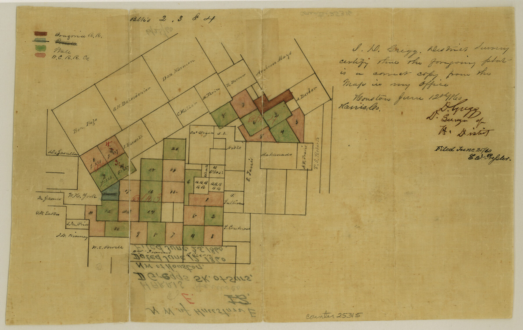
Harris County Sketch File E
[Sketch of surveys northwest of Houston]
-
Map/Doc
25315
-
Collection
General Map Collection
-
Object Dates
1860/6/12 (Creation Date)
1860/6/25 (File Date)
-
People and Organizations
D. Gregg (Surveyor/Engineer)
-
Counties
Harris
-
Subjects
Surveying Sketch File
-
Height x Width
7.6 x 12.1 inches
19.3 x 30.7 cm
-
Medium
paper, manuscript
Part of: General Map Collection
[Location, Fort Worth & Denver Railroad, through Wilbarger County]
![64345, [Location, Fort Worth & Denver Railroad, through Wilbarger County], General Map Collection](https://historictexasmaps.com/wmedia_w700/maps/64345.tif.jpg)
Print $40.00
- Digital $50.00
[Location, Fort Worth & Denver Railroad, through Wilbarger County]
Size 20.7 x 92.7 inches
Map/Doc 64345
Val Verde County Working Sketch 114

Print $20.00
- Digital $50.00
Val Verde County Working Sketch 114
1993
Size 25.9 x 40.9 inches
Map/Doc 72249
Real County Rolled Sketch 18

Print $20.00
- Digital $50.00
Real County Rolled Sketch 18
Size 22.0 x 28.0 inches
Map/Doc 7463
Edwards County Working Sketch 110

Print $40.00
- Digital $50.00
Edwards County Working Sketch 110
1972
Size 49.7 x 39.6 inches
Map/Doc 68986
Harris County Sketch File 62

Print $14.00
- Digital $50.00
Harris County Sketch File 62
1930
Size 11.4 x 8.7 inches
Map/Doc 25486
United States Atlantic and Gulf Coasts Including Puerto Rico and the Virgin Islands

Print $40.00
- Digital $50.00
United States Atlantic and Gulf Coasts Including Puerto Rico and the Virgin Islands
1973
Size 21.5 x 60.4 inches
Map/Doc 76126
Nueces County Rolled Sketch 84

Print $20.00
- Digital $50.00
Nueces County Rolled Sketch 84
1982
Size 18.1 x 24.7 inches
Map/Doc 6970
Red River County Working Sketch 25

Print $20.00
- Digital $50.00
Red River County Working Sketch 25
1959
Size 23.0 x 22.2 inches
Map/Doc 72008
Flight Mission No. CRK-3P, Frame 175, Refugio County

Print $20.00
- Digital $50.00
Flight Mission No. CRK-3P, Frame 175, Refugio County
1956
Size 18.6 x 21.7 inches
Map/Doc 86922
Sutton County Working Sketch 48

Print $20.00
- Digital $50.00
Sutton County Working Sketch 48
1955
Size 34.8 x 33.1 inches
Map/Doc 62391
Grayson County Boundary File 2a

Print $60.00
- Digital $50.00
Grayson County Boundary File 2a
Size 43.7 x 9.8 inches
Map/Doc 53938
Bexar County Sketch File 53

Print $8.00
- Digital $50.00
Bexar County Sketch File 53
Size 11.4 x 8.9 inches
Map/Doc 14539
You may also like
Freestone County Working Sketch 18

Print $20.00
- Digital $50.00
Freestone County Working Sketch 18
1980
Size 43.3 x 46.9 inches
Map/Doc 69260

Tarrant County

Print $20.00
- Digital $50.00
Tarrant County
1856
Size 22.1 x 19.3 inches
Map/Doc 4068
Calhoun County Rolled Sketch 17

Print $20.00
- Digital $50.00
Calhoun County Rolled Sketch 17
1957
Size 24.6 x 30.0 inches
Map/Doc 5370
Chocolate Bay, West Portion of West Bay and Vicinity, and Galveston Cos. Showing Subdivision for Mineral Development.

Print $40.00
- Digital $50.00
Chocolate Bay, West Portion of West Bay and Vicinity, and Galveston Cos. Showing Subdivision for Mineral Development.
1948
Size 43.0 x 55.9 inches
Map/Doc 3012
Map of San Patricio County

Print $40.00
- Digital $50.00
Map of San Patricio County
1896
Size 29.1 x 48.7 inches
Map/Doc 1336
[Jesse Folk and Surrounding Surveys]
![91086, [Jesse Folk and Surrounding Surveys], Twichell Survey Records](https://historictexasmaps.com/wmedia_w700/maps/91086-1.tif.jpg)
Print $20.00
- Digital $50.00
[Jesse Folk and Surrounding Surveys]
Size 14.9 x 18.3 inches
Map/Doc 91086
Orange County Working Sketch 17

Print $20.00
- Digital $50.00
Orange County Working Sketch 17
1930
Size 35.6 x 26.1 inches
Map/Doc 71349
Pecos County Rolled Sketch 146

Print $20.00
- Digital $50.00
Pecos County Rolled Sketch 146
Size 40.8 x 32.5 inches
Map/Doc 9734
The Republic County of Harrison. December 31, 1844

Print $20.00
The Republic County of Harrison. December 31, 1844
2020
Size 18.6 x 21.7 inches
Map/Doc 96176
Taylor County Working Sketch 18

Print $20.00
- Digital $50.00
Taylor County Working Sketch 18
1985
Size 43.2 x 46.0 inches
Map/Doc 69628
Newton County Rolled Sketch 19

Print $20.00
- Digital $50.00
Newton County Rolled Sketch 19
1956
Size 42.1 x 33.5 inches
Map/Doc 6848