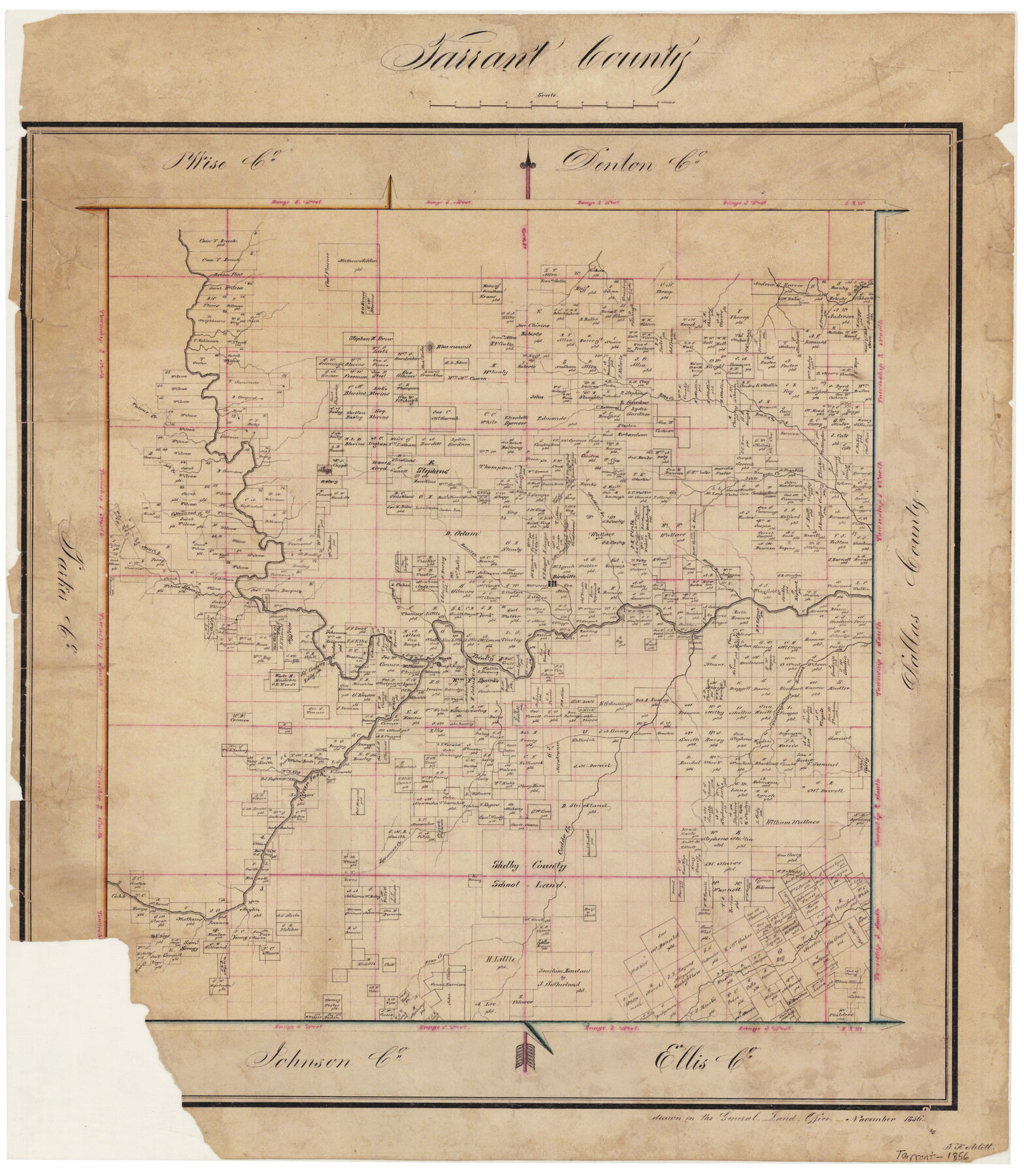
Tarrant County
-
Map/Doc
4068
-
Collection
General Map Collection
-
Object Dates
1856 (Creation Date)
-
People and Organizations
F.H. Arlitt (Draftsman)
-
Counties
Tarrant
-
Subjects
County
-
Height x Width
22.1 x 19.3 inches
56.1 x 49.0 cm
-
Features
Silver Creek
Dear [sic] Creek
Sycamore Creek
Caddo Creek
Clear Fork [of Trinity River]
Fort Worth
Trading House Branch of Trinity River
Honey Branch [of Trinity River]
Trinity River
Birdville
Marine Creek
Live Oak Creek
Denton Creek
Mill Creek
Cottonwood Creek
Little Fossil Creek
Fossil Creek
Walker's Creek
Little Bear Creek
Bear Creek
Ash Creek
Walnut Creek
Bluemound [sic]
Part of: General Map Collection
Tyler County Working Sketch 22

Print $20.00
- Digital $50.00
Tyler County Working Sketch 22
1987
Size 42.0 x 35.5 inches
Map/Doc 69492
Ochiltree County

Print $20.00
- Digital $50.00
Ochiltree County
1908
Size 42.6 x 37.5 inches
Map/Doc 66958
Flight Mission No. BRA-8M, Frame 147, Jefferson County

Print $20.00
- Digital $50.00
Flight Mission No. BRA-8M, Frame 147, Jefferson County
1953
Size 16.0 x 15.9 inches
Map/Doc 85639
Milam County Working Sketch 10

Print $20.00
- Digital $50.00
Milam County Working Sketch 10
1986
Size 25.5 x 34.6 inches
Map/Doc 71025
Maps of Gulf Intracoastal Waterway, Texas - Sabine River to the Rio Grande and connecting waterways including ship channels

Print $20.00
- Digital $50.00
Maps of Gulf Intracoastal Waterway, Texas - Sabine River to the Rio Grande and connecting waterways including ship channels
1966
Size 14.6 x 22.2 inches
Map/Doc 61945
Jefferson County Working Sketch 44

Print $20.00
- Digital $50.00
Jefferson County Working Sketch 44
1960
Size 42.4 x 36.4 inches
Map/Doc 73592
Flight Mission No. BQR-20K, Frame 3, Brazoria County

Print $20.00
- Digital $50.00
Flight Mission No. BQR-20K, Frame 3, Brazoria County
1952
Size 18.6 x 22.2 inches
Map/Doc 84105
Flight Mission No. BQY-4M, Frame 118, Harris County

Print $20.00
- Digital $50.00
Flight Mission No. BQY-4M, Frame 118, Harris County
1953
Size 18.6 x 22.3 inches
Map/Doc 85285
Flight Mission No. DAG-24K, Frame 41, Matagorda County

Print $20.00
- Digital $50.00
Flight Mission No. DAG-24K, Frame 41, Matagorda County
1953
Size 18.5 x 22.4 inches
Map/Doc 86528
Map of Matagorda Bay and County with the Adjacent Country

Print $20.00
- Digital $50.00
Map of Matagorda Bay and County with the Adjacent Country
1839
Size 33.4 x 42.6 inches
Map/Doc 2002
Coke County Rolled Sketch 15

Print $40.00
- Digital $50.00
Coke County Rolled Sketch 15
1949
Size 48.1 x 46.5 inches
Map/Doc 8628

You may also like

Red River County Sketch File 9

Print $10.00
- Digital $50.00
Red River County Sketch File 9
1862
Size 12.6 x 8.2 inches
Map/Doc 35117
Wise County Working Sketch 30

Print $20.00
- Digital $50.00
Wise County Working Sketch 30
1999
Size 39.2 x 34.3 inches
Map/Doc 72644
Calhoun County Rolled Sketch 14

Print $20.00
- Digital $50.00
Calhoun County Rolled Sketch 14
Size 22.1 x 40.6 inches
Map/Doc 5460
Americae Sive Novi Orbis, Nova Descriptio

Print $20.00
- Digital $50.00
Americae Sive Novi Orbis, Nova Descriptio
1573
Size 15.6 x 22.3 inches
Map/Doc 95834
Gaines County Working Sketch 32

Print $20.00
- Digital $50.00
Gaines County Working Sketch 32
1990
Size 38.3 x 26.3 inches
Map/Doc 69332
Pecos County Boundary File 2

Print $38.00
- Digital $50.00
Pecos County Boundary File 2
Size 11.2 x 8.7 inches
Map/Doc 57871
Dawson County Boundary File 3

Print $36.00
- Digital $50.00
Dawson County Boundary File 3
Size 14.1 x 8.6 inches
Map/Doc 52347
Map of Brett Ranch situated in McMullen & La Salle Counties

Print $20.00
- Digital $50.00
Map of Brett Ranch situated in McMullen & La Salle Counties
Size 20.0 x 22.3 inches
Map/Doc 5068
Gulf of Mexico

Print $20.00
- Digital $50.00
Gulf of Mexico
1908
Size 18.4 x 27.0 inches
Map/Doc 72657
Sutton County Working Sketch 23

Print $20.00
- Digital $50.00
Sutton County Working Sketch 23
1981
Size 17.3 x 27.1 inches
Map/Doc 62366
Mapa Original de Texas por El Ciudadano Estevan F. Austin Presentado al Exmo. Sr. Presidente por su autor 1829

Print $20.00
Mapa Original de Texas por El Ciudadano Estevan F. Austin Presentado al Exmo. Sr. Presidente por su autor 1829
1829
Size 33.4 x 28.1 inches
Map/Doc 76201