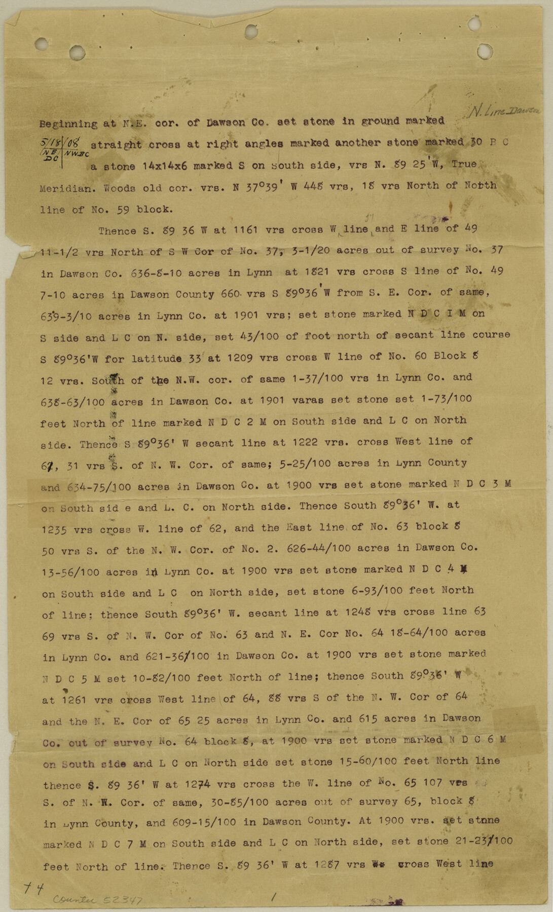
Dawson County Boundary File 3
Certified Copy of County lines of Dawson County Texas
-
Map/Doc
52347
-
Collection
General Map Collection
-
Counties
Dawson
-
Subjects
County Boundaries
-
Height x Width
14.1 x 8.6 inches
35.8 x 21.8 cm
Part of: General Map Collection
Navarro County Working Sketch 6

Print $20.00
- Digital $50.00
Navarro County Working Sketch 6
1950
Size 25.3 x 33.7 inches
Map/Doc 71236
Brazoria County Sketch File 5

Print $4.00
- Digital $50.00
Brazoria County Sketch File 5
1862
Size 13.1 x 8.1 inches
Map/Doc 14929
Trinity River, Bazzette Sheet

Print $20.00
- Digital $50.00
Trinity River, Bazzette Sheet
1925
Size 27.9 x 23.8 inches
Map/Doc 78339
Roberts County Working Sketch 1

Print $20.00
- Digital $50.00
Roberts County Working Sketch 1
1922
Size 17.6 x 17.7 inches
Map/Doc 63527
Fannin County Boundary File 2

Print $27.00
- Digital $50.00
Fannin County Boundary File 2
Size 13.4 x 8.8 inches
Map/Doc 53282
Gulf Coast of the United States, Key West to Rio Grande

Print $20.00
- Digital $50.00
Gulf Coast of the United States, Key West to Rio Grande
1863
Size 27.4 x 18.3 inches
Map/Doc 72666
Flight Mission No. DQN-2K, Frame 1, Calhoun County

Print $20.00
- Digital $50.00
Flight Mission No. DQN-2K, Frame 1, Calhoun County
1953
Size 18.5 x 22.2 inches
Map/Doc 84218
Young County Sketch File 10c

Print $4.00
- Digital $50.00
Young County Sketch File 10c
1878
Size 8.2 x 15.4 inches
Map/Doc 40872
Webb County Working Sketch 88

Print $20.00
- Digital $50.00
Webb County Working Sketch 88
1982
Size 24.2 x 19.7 inches
Map/Doc 72455
Lampasas County Working Sketch 3

Print $20.00
- Digital $50.00
Lampasas County Working Sketch 3
1941
Size 25.0 x 14.6 inches
Map/Doc 70280
Trinity County Working Sketch 8

Print $3.00
- Digital $50.00
Trinity County Working Sketch 8
1941
Size 14.7 x 10.8 inches
Map/Doc 69457
Bosque County Working Sketch 27

Print $20.00
- Digital $50.00
Bosque County Working Sketch 27
2006
Size 29.8 x 38.0 inches
Map/Doc 85241
You may also like
Mapa de los Estados Unidos Mejicanos arreglado a la distribucion que en diversos decretos ha hecho del territorio el Congreso General Mejicano

Print $20.00
- Digital $50.00
Mapa de los Estados Unidos Mejicanos arreglado a la distribucion que en diversos decretos ha hecho del territorio el Congreso General Mejicano
1851
Size 24.6 x 30.3 inches
Map/Doc 96514
Bell County Working Sketch 8

Print $20.00
- Digital $50.00
Bell County Working Sketch 8
1954
Size 44.2 x 37.3 inches
Map/Doc 67348
Montgomery County Rolled Sketch 48

Print $20.00
- Digital $50.00
Montgomery County Rolled Sketch 48
2007
Size 11.2 x 17.2 inches
Map/Doc 89278
Dimmit County Rolled Sketch 22A

Print $20.00
- Digital $50.00
Dimmit County Rolled Sketch 22A
2012
Size 23.2 x 34.0 inches
Map/Doc 93630
Starr County Rolled Sketch 36

Print $20.00
- Digital $50.00
Starr County Rolled Sketch 36
1947
Size 34.1 x 35.4 inches
Map/Doc 9941
Dickens County Boundary File 5

Print $12.00
- Digital $50.00
Dickens County Boundary File 5
Size 10.8 x 8.2 inches
Map/Doc 52554
[Surveys in Austin's Colony along the Brazos River]
![214, [Surveys in Austin's Colony along the Brazos River], General Map Collection](https://historictexasmaps.com/wmedia_w700/maps/214.tif.jpg)
Print $2.00
- Digital $50.00
[Surveys in Austin's Colony along the Brazos River]
Size 9.0 x 8.7 inches
Map/Doc 214
Liberty County Working Sketch 67

Print $20.00
- Digital $50.00
Liberty County Working Sketch 67
1971
Size 35.3 x 44.5 inches
Map/Doc 70527
Wise County Sketch File 19

Print $4.00
- Digital $50.00
Wise County Sketch File 19
1857
Size 11.0 x 8.2 inches
Map/Doc 40555
Map of Nacogdoches County

Print $40.00
- Digital $50.00
Map of Nacogdoches County
1839
Size 83.6 x 41.6 inches
Map/Doc 93371
Flight Mission No. CRC-6R, Frame 39, Chambers County

Print $20.00
- Digital $50.00
Flight Mission No. CRC-6R, Frame 39, Chambers County
1956
Size 18.7 x 22.5 inches
Map/Doc 84972
San Jacinto County Rolled Sketch 6

Print $20.00
- Digital $50.00
San Jacinto County Rolled Sketch 6
Size 42.1 x 43.5 inches
Map/Doc 8361