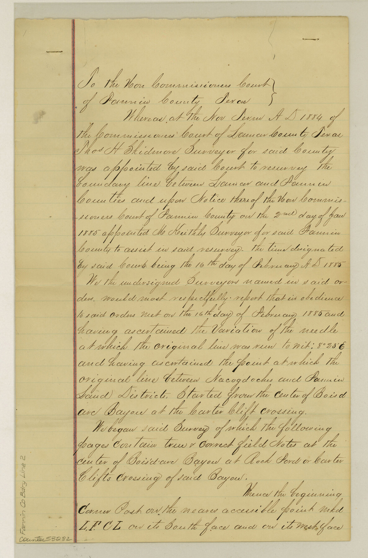
Fannin County Boundary File 2
Map of Fannin and Lamar County Line
-
Map/Doc
53282
-
Collection
General Map Collection
-
Counties
Fannin
-
Subjects
County Boundaries
-
Height x Width
13.4 x 8.8 inches
34.0 x 22.4 cm
Part of: General Map Collection
Van Zandt County Sketch File 15b

Print $4.00
- Digital $50.00
Van Zandt County Sketch File 15b
1858
Size 12.2 x 7.7 inches
Map/Doc 39408
Howard County Working Sketch 7a

Print $40.00
- Digital $50.00
Howard County Working Sketch 7a
1950
Size 81.9 x 24.7 inches
Map/Doc 66273
Calhoun County

Print $20.00
- Digital $50.00
Calhoun County
1882
Size 22.7 x 18.7 inches
Map/Doc 3359
Erath County Working Sketch 46

Print $40.00
- Digital $50.00
Erath County Working Sketch 46
1983
Size 49.6 x 43.1 inches
Map/Doc 69127
[Surveys in the Liberty District]
![162, [Surveys in the Liberty District], General Map Collection](https://historictexasmaps.com/wmedia_w700/maps/162.tif.jpg)
Print $2.00
- Digital $50.00
[Surveys in the Liberty District]
1841
Size 7.6 x 10.3 inches
Map/Doc 162
Montgomery County Working Sketch 29

Print $20.00
- Digital $50.00
Montgomery County Working Sketch 29
1942
Size 32.3 x 33.9 inches
Map/Doc 71136
Railroad Track Map, H&TCRRCo., Falls County, Texas

Print $4.00
- Digital $50.00
Railroad Track Map, H&TCRRCo., Falls County, Texas
1918
Size 11.9 x 18.5 inches
Map/Doc 62832
Kinney County Working Sketch 6

Print $20.00
- Digital $50.00
Kinney County Working Sketch 6
1908
Size 19.6 x 23.9 inches
Map/Doc 70188
Duval County Sketch File 40b

Print $20.00
- Digital $50.00
Duval County Sketch File 40b
Size 28.0 x 31.4 inches
Map/Doc 11396

Edwards County Working Sketch 54

Print $20.00
- Digital $50.00
Edwards County Working Sketch 54
1951
Size 19.2 x 28.5 inches
Map/Doc 68930
Old Miscellaneous File 5

Print $4.00
- Digital $50.00
Old Miscellaneous File 5
1846
Size 4.8 x 7.6 inches
Map/Doc 75418
You may also like
Plat Showing Proposed Dam & Reservoir Under Application No. 561 Located at Mouth of Clear Fork of Brazos River

Print $20.00
- Digital $50.00
Plat Showing Proposed Dam & Reservoir Under Application No. 561 Located at Mouth of Clear Fork of Brazos River
1921
Size 24.0 x 16.6 inches
Map/Doc 92094
Right-of-Way & Track Map, Houston and Brazos Valley Ry. Co. operated by the Houston and Brazos Valley Ry. Co.

Print $40.00
- Digital $50.00
Right-of-Way & Track Map, Houston and Brazos Valley Ry. Co. operated by the Houston and Brazos Valley Ry. Co.
1918
Size 24.7 x 56.7 inches
Map/Doc 64604
Vicinity of San Luis Pass, Galveston Island, Texas

Print $40.00
- Digital $50.00
Vicinity of San Luis Pass, Galveston Island, Texas
1933
Size 37.1 x 57.8 inches
Map/Doc 69943
Reconnaissance Map, Roby Sheet

Print $20.00
- Digital $50.00
Reconnaissance Map, Roby Sheet
1893
Size 17.0 x 20.8 inches
Map/Doc 90869
Coke County Sketch File 31

Print $4.00
- Digital $50.00
Coke County Sketch File 31
Size 14.1 x 8.8 inches
Map/Doc 18643
Gregg County Rolled Sketch 25

Print $40.00
- Digital $50.00
Gregg County Rolled Sketch 25
1933
Size 27.3 x 51.7 inches
Map/Doc 9076
South Sulphur River, Klondike Sheet

Print $6.00
- Digital $50.00
South Sulphur River, Klondike Sheet
1925
Size 32.2 x 35.5 inches
Map/Doc 65170
Kimble County Sketch File 8

Print $14.00
- Digital $50.00
Kimble County Sketch File 8
1847
Size 7.7 x 7.0 inches
Map/Doc 28920
Pecos County Working Sketch 21

Print $20.00
- Digital $50.00
Pecos County Working Sketch 21
1925
Size 27.3 x 29.0 inches
Map/Doc 71491
Tom Green County Working Sketch 15

Print $20.00
- Digital $50.00
Tom Green County Working Sketch 15
1988
Size 32.9 x 37.5 inches
Map/Doc 69384
Louisiana and Texas Intracoastal Waterway, Section 7, Galveston Bay to Brazos River and Section 8, Brazos River to Matagorda Bay

Print $20.00
- Digital $50.00
Louisiana and Texas Intracoastal Waterway, Section 7, Galveston Bay to Brazos River and Section 8, Brazos River to Matagorda Bay
1937
Size 31.0 x 42.8 inches
Map/Doc 61843
Texas, the Empire State of the Southwest

Texas, the Empire State of the Southwest
1909
Size 9.7 x 5.4 inches
Map/Doc 96603