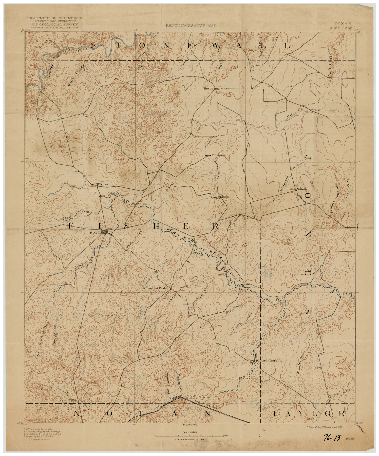
Reconnaissance Map, Roby Sheet
76-13
-
Map/Doc
90869
-
Collection
Twichell Survey Records
-
Object Dates
9/1893 (Creation Date)
-
People and Organizations
U. S. Geological Survey (Publisher)
-
Counties
Fisher Stonewall Jones Taylor
-
Height x Width
17.0 x 20.8 inches
43.2 x 52.8 cm
Part of: Twichell Survey Records
[Beaty and Moulton Block A, Southern Pacific Railroad Block 2]
![91398, [Beaty and Moulton Block A, Southern Pacific Railroad Block 2], Twichell Survey Records](https://historictexasmaps.com/wmedia_w700/maps/91398-1.tif.jpg)
Print $20.00
- Digital $50.00
[Beaty and Moulton Block A, Southern Pacific Railroad Block 2]
1914
Size 24.2 x 15.4 inches
Map/Doc 91398
[Map Showing Fence Line between Blocks XIT and LS]
![91408, [Map Showing Fence Line between Blocks XIT and LS], Twichell Survey Records](https://historictexasmaps.com/wmedia_w700/maps/91408-1.tif.jpg)
Print $20.00
- Digital $50.00
[Map Showing Fence Line between Blocks XIT and LS]
1886
Size 18.4 x 16.7 inches
Map/Doc 91408
[Area around John P. Rohus Survey]
![91913, [Area around John P. Rohus Survey], Twichell Survey Records](https://historictexasmaps.com/wmedia_w700/maps/91913-1.tif.jpg)
Print $20.00
- Digital $50.00
[Area around John P. Rohus Survey]
Size 19.7 x 19.7 inches
Map/Doc 91913
[Map of Resurvey of Block 34 and 35, Township 5 N]
![90551, [Map of Resurvey of Block 34 and 35, Township 5 N], Twichell Survey Records](https://historictexasmaps.com/wmedia_w700/maps/90551-1.tif.jpg)
Print $20.00
- Digital $50.00
[Map of Resurvey of Block 34 and 35, Township 5 N]
1915
Size 25.5 x 16.4 inches
Map/Doc 90551
[Sketch of part of Blks. 4, B5, 6, 2Z, M6, M8, and M13]
![89645, [Sketch of part of Blks. 4, B5, 6, 2Z, M6, M8, and M13], Twichell Survey Records](https://historictexasmaps.com/wmedia_w700/maps/89645-1.tif.jpg)
Print $40.00
- Digital $50.00
[Sketch of part of Blks. 4, B5, 6, 2Z, M6, M8, and M13]
Size 22.7 x 55.3 inches
Map/Doc 89645
W. W. Boatright Subdivision of 5 Acres out of North Half of Survey Number 1, Block Number 36, Township 5 North. Dawson County, Texas

Print $20.00
- Digital $50.00
W. W. Boatright Subdivision of 5 Acres out of North Half of Survey Number 1, Block Number 36, Township 5 North. Dawson County, Texas
1924
Size 18.8 x 24.6 inches
Map/Doc 92590
[B. S. & F. Block 9 and surrounding area]
![93070, [B. S. & F. Block 9 and surrounding area], Twichell Survey Records](https://historictexasmaps.com/wmedia_w700/maps/93070-1.tif.jpg)
Print $20.00
- Digital $50.00
[B. S. & F. Block 9 and surrounding area]
Size 18.3 x 26.1 inches
Map/Doc 93070
Renderbrook Ranch, Mitchell, Sterling & Coke Counties, Texas Owned by I. L. Ellwood, Estate

Print $40.00
- Digital $50.00
Renderbrook Ranch, Mitchell, Sterling & Coke Counties, Texas Owned by I. L. Ellwood, Estate
Size 50.1 x 40.0 inches
Map/Doc 89873
[Sketch showing Panhandle and Santa Fe Railroad, Compress Spur and Seed House structures]
![92880, [Sketch showing Panhandle and Santa Fe Railroad, Compress Spur and Seed House structures], Twichell Survey Records](https://historictexasmaps.com/wmedia_w700/maps/92880-1.tif.jpg)
Print $20.00
- Digital $50.00
[Sketch showing Panhandle and Santa Fe Railroad, Compress Spur and Seed House structures]
Size 20.8 x 22.8 inches
Map/Doc 92880
[Capitol Leagues 217-228, 238, and vicinity]
![90674, [Capitol Leagues 217-228, 238, and vicinity], Twichell Survey Records](https://historictexasmaps.com/wmedia_w700/maps/90674-1.tif.jpg)
Print $20.00
- Digital $50.00
[Capitol Leagues 217-228, 238, and vicinity]
Size 22.8 x 10.0 inches
Map/Doc 90674
[Worksheets related to the Wilson Strickland survey and vicinity]
![91350, [Worksheets related to the Wilson Strickland survey and vicinity], Twichell Survey Records](https://historictexasmaps.com/wmedia_w700/maps/91350-1.tif.jpg)
Print $20.00
- Digital $50.00
[Worksheets related to the Wilson Strickland survey and vicinity]
Size 29.6 x 43.6 inches
Map/Doc 91350
[Mrs. May Vinson Survey]
![91959, [Mrs. May Vinson Survey], Twichell Survey Records](https://historictexasmaps.com/wmedia_w700/maps/91959-1.tif.jpg)
Print $40.00
- Digital $50.00
[Mrs. May Vinson Survey]
Size 48.4 x 21.9 inches
Map/Doc 91959
You may also like
[Coleman County Sections 359, 360, and 361]
![92552, [Coleman County Sections 359, 360, and 361], Twichell Survey Records](https://historictexasmaps.com/wmedia_w700/maps/92552-1.tif.jpg)
Print $20.00
- Digital $50.00
[Coleman County Sections 359, 360, and 361]
1946
Size 17.6 x 22.6 inches
Map/Doc 92552
Archer County Working Sketch 13

Print $20.00
- Digital $50.00
Archer County Working Sketch 13
1939
Size 12.0 x 18.5 inches
Map/Doc 67154
Flight Mission No. CGN-3P, Frame 141, San Patricio County

Print $20.00
- Digital $50.00
Flight Mission No. CGN-3P, Frame 141, San Patricio County
1956
Size 18.6 x 22.4 inches
Map/Doc 86985
Travis County Rolled Sketch 26

Print $20.00
- Digital $50.00
Travis County Rolled Sketch 26
1945
Size 24.6 x 25.2 inches
Map/Doc 8028
Republic of Texas and Boundaries as Claimed by Texas from Decr. 19th, 1836 to Novr. 25th, 1850

Print $20.00
- Digital $50.00
Republic of Texas and Boundaries as Claimed by Texas from Decr. 19th, 1836 to Novr. 25th, 1850
Size 18.4 x 20.8 inches
Map/Doc 92063
Nueces River, Calallen Sheet

Print $20.00
- Digital $50.00
Nueces River, Calallen Sheet
1927
Size 32.7 x 37.3 inches
Map/Doc 65087
Navarro County

Print $40.00
- Digital $50.00
Navarro County
1924
Size 41.1 x 48.2 inches
Map/Doc 77382
Map of the Houston & Great Northern Railroad

Print $40.00
- Digital $50.00
Map of the Houston & Great Northern Railroad
1871
Size 29.3 x 122.1 inches
Map/Doc 64551
Sterling County Sketch File 18

Print $8.00
- Digital $50.00
Sterling County Sketch File 18
1939
Size 11.2 x 8.7 inches
Map/Doc 37161
Sterling County Rolled Sketch 9

Print $20.00
- Digital $50.00
Sterling County Rolled Sketch 9
1929
Size 29.3 x 24.3 inches
Map/Doc 7845
Parker County Sketch File 17

Print $6.00
- Digital $50.00
Parker County Sketch File 17
Size 10.7 x 9.5 inches
Map/Doc 33552
Runnels County Boundary File 2

Print $36.00
- Digital $50.00
Runnels County Boundary File 2
Size 14.4 x 8.8 inches
Map/Doc 58517