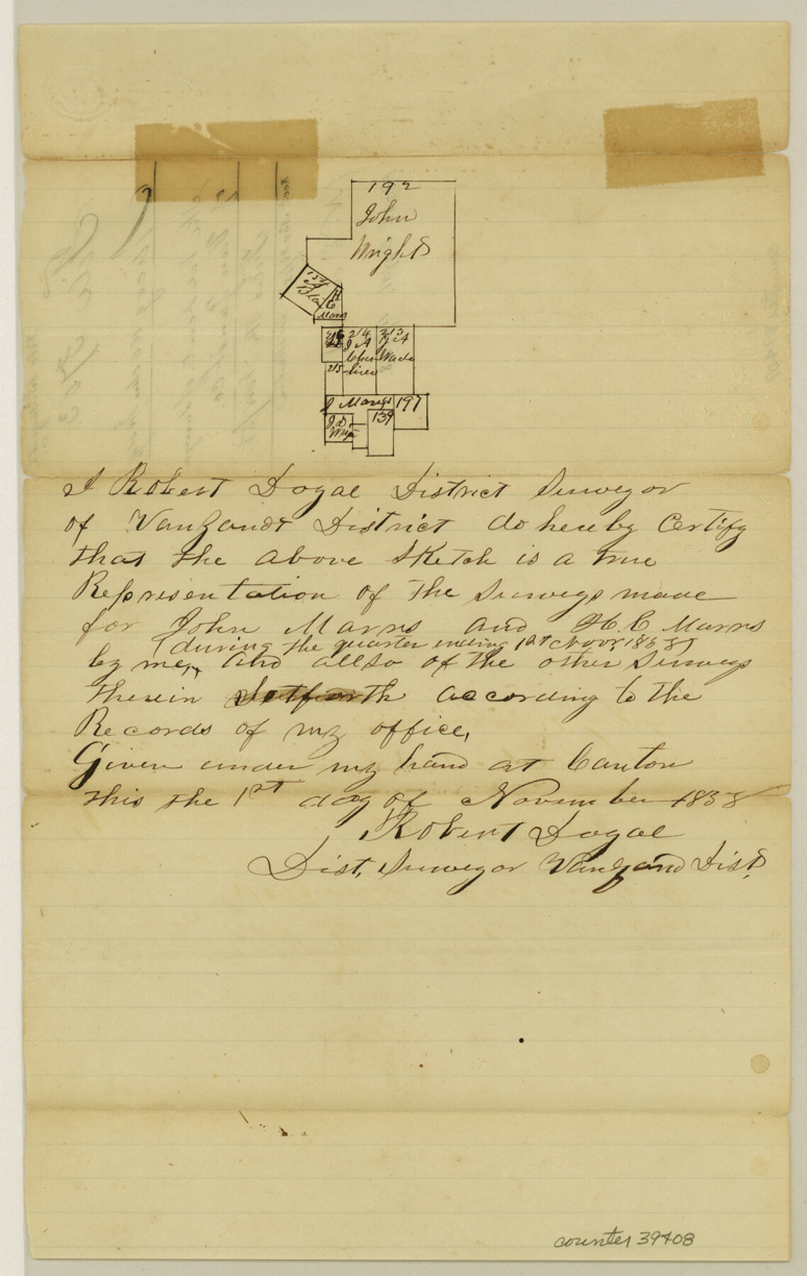
Van Zandt County Sketch File 15b
[Sketch of surveys northeast from Canton]
-
Map/Doc
39408
-
Collection
General Map Collection
-
Object Dates
11/1/1858 (Creation Date)
11/8/1858 (File Date)
-
People and Organizations
Robert Doyal (Surveyor/Engineer)
-
Counties
Van Zandt
-
Subjects
Surveying Sketch File
-
Height x Width
12.2 x 7.7 inches
31.0 x 19.6 cm
-
Medium
paper, manuscript
Part of: General Map Collection
Menard County

Print $20.00
- Digital $50.00
Menard County
1942
Size 41.2 x 43.4 inches
Map/Doc 73238
Glasscock County Working Sketch 14

Print $40.00
- Digital $50.00
Glasscock County Working Sketch 14
1984
Size 67.0 x 42.1 inches
Map/Doc 63187
Real County Rolled Sketch 18

Print $20.00
- Digital $50.00
Real County Rolled Sketch 18
Size 22.0 x 28.0 inches
Map/Doc 7464
Nueces County Rolled Sketch 98

Print $34.00
- Digital $50.00
Nueces County Rolled Sketch 98
1984
Size 24.5 x 36.4 inches
Map/Doc 7059
Lynn County Rolled Sketch 3

Print $20.00
- Digital $50.00
Lynn County Rolled Sketch 3
Size 27.3 x 29.9 inches
Map/Doc 6644
Limestone County Working Sketch 11

Print $20.00
- Digital $50.00
Limestone County Working Sketch 11
1922
Size 36.1 x 33.9 inches
Map/Doc 70561
Guadalupe County Sketch File 7

Print $20.00
- Digital $50.00
Guadalupe County Sketch File 7
Size 15.6 x 19.5 inches
Map/Doc 11590
Dallam County Boundary File 2

Print $18.00
- Digital $50.00
Dallam County Boundary File 2
Size 8.7 x 4.3 inches
Map/Doc 52053
Flight Mission No. CLL-4N, Frame 32, Willacy County

Print $20.00
- Digital $50.00
Flight Mission No. CLL-4N, Frame 32, Willacy County
1954
Size 18.5 x 22.1 inches
Map/Doc 87105
[Galveston, Harrisburg & San Antonio Railroad from Cuero to Stockdale]
![64193, [Galveston, Harrisburg & San Antonio Railroad from Cuero to Stockdale], General Map Collection](https://historictexasmaps.com/wmedia_w700/maps/64193.tif.jpg)
Print $20.00
- Digital $50.00
[Galveston, Harrisburg & San Antonio Railroad from Cuero to Stockdale]
1907
Size 13.7 x 34.0 inches
Map/Doc 64193
Intracoastal Waterway in Texas - Corpus Christi to Point Isabel including Arroyo Colorado to Mo. Pac. R.R. Bridge Near Harlingen

Print $20.00
- Digital $50.00
Intracoastal Waterway in Texas - Corpus Christi to Point Isabel including Arroyo Colorado to Mo. Pac. R.R. Bridge Near Harlingen
1934
Size 22.0 x 32.7 inches
Map/Doc 61884
Young County Rolled Sketch 13

Print $20.00
- Digital $50.00
Young County Rolled Sketch 13
1966
Size 24.8 x 16.9 inches
Map/Doc 8301
You may also like
Flight Mission No. CGI-3N, Frame 163, Cameron County

Print $20.00
- Digital $50.00
Flight Mission No. CGI-3N, Frame 163, Cameron County
1954
Size 18.5 x 22.3 inches
Map/Doc 84627
Refugio County Boundary File 5

Print $4.00
- Digital $50.00
Refugio County Boundary File 5
Size 11.2 x 8.6 inches
Map/Doc 58256
Runnels County Sketch File 2

Print $6.00
Runnels County Sketch File 2
1854
Size 8.2 x 7.8 inches
Map/Doc 35431
Val Verde County Sketch File Z19

Print $26.00
- Digital $50.00
Val Verde County Sketch File Z19
1912
Size 23.1 x 21.1 inches
Map/Doc 12559
Starr County Rolled Sketch 21

Print $20.00
- Digital $50.00
Starr County Rolled Sketch 21
1921
Size 24.2 x 14.0 inches
Map/Doc 7805
Chart showing the positions of the lights in the Eighth L. H. District extending from the Perdido River, Florida to the Rio Grande, Texas

Print $20.00
- Digital $50.00
Chart showing the positions of the lights in the Eighth L. H. District extending from the Perdido River, Florida to the Rio Grande, Texas
1876
Size 24.7 x 18.2 inches
Map/Doc 72682
Travis County Rolled Sketch 40

Print $407.00
- Digital $50.00
Travis County Rolled Sketch 40
1953
Size 10.4 x 15.4 inches
Map/Doc 49195
Jones & Murphy's Map of the City of Dallas, Texas compiled from the records of Dallas Co., and latest surveys of the City Engineer

Print $20.00
- Digital $50.00
Jones & Murphy's Map of the City of Dallas, Texas compiled from the records of Dallas Co., and latest surveys of the City Engineer
1878
Size 22.0 x 29.9 inches
Map/Doc 97262
Flight Mission No. CRC-4R, Frame 110, Chambers County

Print $20.00
- Digital $50.00
Flight Mission No. CRC-4R, Frame 110, Chambers County
1956
Size 18.6 x 22.3 inches
Map/Doc 84907
Terrell County Rolled Sketch 59

Print $20.00
- Digital $50.00
Terrell County Rolled Sketch 59
Size 32.5 x 28.2 inches
Map/Doc 7975
Wharton County Rolled Sketch 10

Print $20.00
- Digital $50.00
Wharton County Rolled Sketch 10
Size 21.9 x 32.8 inches
Map/Doc 8234
