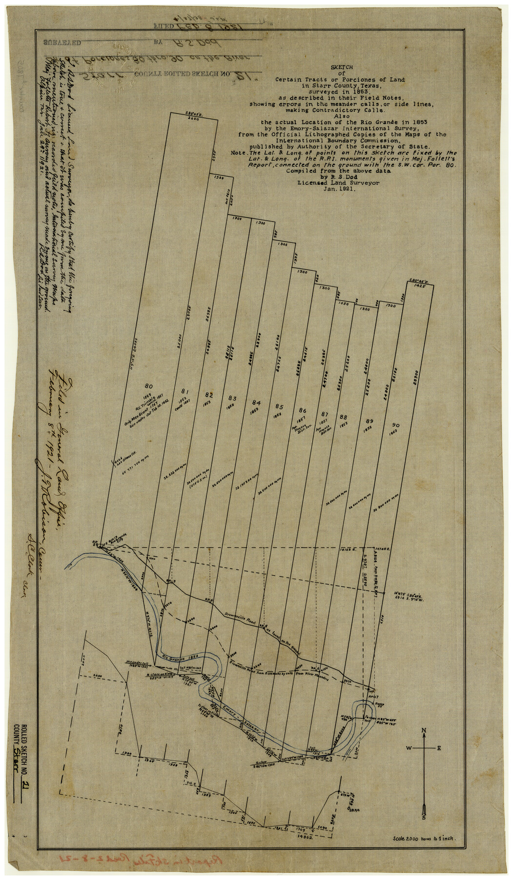
Starr County Rolled Sketch 21
Sketch of certain tracts or Porciones of land in Starr County, Texas surveyed in 1853 as described in their field notes showing errors in the meander calls, or side lines, making contradictory calls
-
Map/Doc
7805
-
Collection
General Map Collection
-
Object Dates
1/29/1921 (Creation Date)
2/8/1921 (File Date)
-
People and Organizations
R.S. Dod (Surveyor/Engineer)
-
Counties
Starr
-
Subjects
Surveying Rolled Sketch
-
Height x Width
24.2 x 14.0 inches
61.5 x 35.6 cm
-
Medium
linen, manuscript
-
Scale
1" = 2000 varas
Part of: General Map Collection
Coke County Rolled Sketch 2

Print $20.00
- Digital $50.00
Coke County Rolled Sketch 2
1947
Size 15.5 x 17.4 inches
Map/Doc 5504
Tarrant County Working Sketch 12

Print $20.00
- Digital $50.00
Tarrant County Working Sketch 12
1986
Size 30.8 x 23.4 inches
Map/Doc 62429
Harris County NRC Article 33.136 Sketch 13

Print $28.00
- Digital $50.00
Harris County NRC Article 33.136 Sketch 13
2009
Size 36.0 x 24.3 inches
Map/Doc 94641
Gaines County Working Sketch 4

Print $20.00
- Digital $50.00
Gaines County Working Sketch 4
1939
Size 44.5 x 43.1 inches
Map/Doc 69304
Atascosa County Rolled Sketch R

Print $20.00
- Digital $50.00
Atascosa County Rolled Sketch R
Size 19.6 x 19.6 inches
Map/Doc 5103
San Augustine County Sketch File 17

Print $35.00
San Augustine County Sketch File 17
1947
Size 11.5 x 8.7 inches
Map/Doc 35668
Map of the Western Part of Bexar District

Print $40.00
- Digital $50.00
Map of the Western Part of Bexar District
1849
Size 63.5 x 21.6 inches
Map/Doc 87375
Knox County Sketch File 9

Print $4.00
- Digital $50.00
Knox County Sketch File 9
1889
Size 11.1 x 8.8 inches
Map/Doc 29221
Flight Mission No. BRA-6M, Frame 97, Jefferson County

Print $20.00
- Digital $50.00
Flight Mission No. BRA-6M, Frame 97, Jefferson County
1953
Size 18.7 x 22.3 inches
Map/Doc 85440
Upton County Sketch File 25

Print $20.00
- Digital $50.00
Upton County Sketch File 25
1928
Size 27.1 x 44.4 inches
Map/Doc 10415
Tom Green County Rolled Sketch 19

Print $20.00
- Digital $50.00
Tom Green County Rolled Sketch 19
1959
Size 35.0 x 32.1 inches
Map/Doc 8002
Flight Mission No. BRE-2P, Frame 136, Nueces County

Print $20.00
- Digital $50.00
Flight Mission No. BRE-2P, Frame 136, Nueces County
1956
Size 18.5 x 22.6 inches
Map/Doc 86809
You may also like
Comanche County Working Sketch 10

Print $20.00
- Digital $50.00
Comanche County Working Sketch 10
1954
Size 21.4 x 18.0 inches
Map/Doc 68144
The Republic County of Austin. December 29, 1845

Print $20.00
The Republic County of Austin. December 29, 1845
2020
Size 14.7 x 21.6 inches
Map/Doc 96088
Val Verde County Working Sketch 117

Print $20.00
- Digital $50.00
Val Verde County Working Sketch 117
1993
Size 17.5 x 24.4 inches
Map/Doc 82848
G. C. & S. F. Ry. Alinement [sic] and Right of Way Map of Dallas Branch, Johnson County, Texas
![64650, G. C. & S. F. Ry. Alinement [sic] and Right of Way Map of Dallas Branch, Johnson County, Texas, General Map Collection](https://historictexasmaps.com/wmedia_w700/maps/64650.tif.jpg)
Print $40.00
- Digital $50.00
G. C. & S. F. Ry. Alinement [sic] and Right of Way Map of Dallas Branch, Johnson County, Texas
1925
Size 38.0 x 125.2 inches
Map/Doc 64650
El Paso County Working Sketch 28

Print $20.00
- Digital $50.00
El Paso County Working Sketch 28
1966
Size 24.0 x 31.5 inches
Map/Doc 69050
Wilbarger Co.

Print $40.00
- Digital $50.00
Wilbarger Co.
1907
Size 48.8 x 39.8 inches
Map/Doc 63127
Leon County Working Sketch 21

Print $20.00
- Digital $50.00
Leon County Working Sketch 21
1964
Size 20.9 x 22.9 inches
Map/Doc 70420
Montgomery County Rolled Sketch 41

Print $20.00
- Digital $50.00
Montgomery County Rolled Sketch 41
1975
Size 35.2 x 26.8 inches
Map/Doc 6814
Lipscomb County Rolled Sketch 3

Print $20.00
- Digital $50.00
Lipscomb County Rolled Sketch 3
1886
Size 24.2 x 31.0 inches
Map/Doc 6629
Flight Mission No. DQN-7K, Frame 88, Calhoun County

Print $20.00
- Digital $50.00
Flight Mission No. DQN-7K, Frame 88, Calhoun County
1953
Size 18.5 x 22.1 inches
Map/Doc 84479
Colorado County Sketch File 12

Print $20.00
- Digital $50.00
Colorado County Sketch File 12
Size 14.6 x 17.8 inches
Map/Doc 11135
[Leagues 682, 683, 696, 697]
![92230, [Leagues 682, 683, 696, 697], Twichell Survey Records](https://historictexasmaps.com/wmedia_w700/maps/92230-1.tif.jpg)
Print $20.00
- Digital $50.00
[Leagues 682, 683, 696, 697]
Size 19.8 x 20.0 inches
Map/Doc 92230