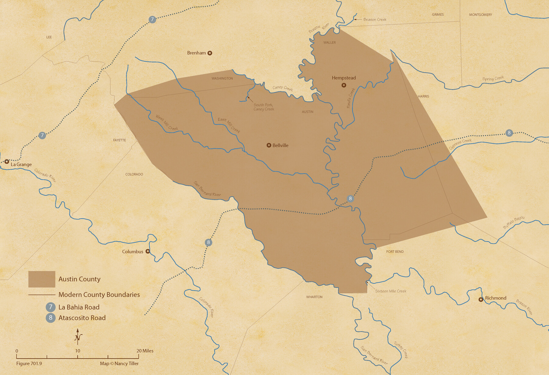
The Republic County of Austin. December 29, 1845
Figure No. 701.9 from 'A Boundary Atlas of Texas, 1821-1845' by Jim Tiller
-
Map/Doc
96088
-
Collection
Nancy and Jim Tiller Digital Collection
-
Object Dates
2020/1/1 (Creation Date)
-
People and Organizations
Jim Tiller (Author)
Nancy Tiller (Cartographer)
Gang Gong (GIS Professional)
-
Counties
Austin
-
Subjects
Atlas County Republic of Texas Texas Boundaries
-
Height x Width
14.7 x 21.6 inches
37.3 x 54.9 cm
-
Medium
digital image
-
Comments
To purchase a digital PDF copy of "A Boundary Atlas of Texas, 1821-1845" see 96437.
Part of: Nancy and Jim Tiller Digital Collection
Thorn Empresario Colony. April 25, 1825

Print $20.00
Thorn Empresario Colony. April 25, 1825
2020
Size 17.0 x 21.7 inches
Map/Doc 96006
The Republic County of Washington. January 15, 1842

Print $20.00
The Republic County of Washington. January 15, 1842
2020
Size 11.8 x 21.7 inches
Map/Doc 96306
The Republic County of Bastrop. Boundaries Defined, December 18, 1837

Print $20.00
The Republic County of Bastrop. Boundaries Defined, December 18, 1837
2020
Size 14.7 x 21.7 inches
Map/Doc 96089
The Republic County of Liberty. December 29, 1845

Print $20.00
The Republic County of Liberty. December 29, 1845
2020
Size 19.9 x 21.7 inches
Map/Doc 96213
The Republic County of Liberty. December 7, 1841

Print $20.00
The Republic County of Liberty. December 7, 1841
2020
Size 19.9 x 21.7 inches
Map/Doc 96211
The Republic County of Harrison. June 24, 1841

Print $20.00
The Republic County of Harrison. June 24, 1841
2020
Size 18.6 x 21.7 inches
Map/Doc 96171
The Land Offices. No. 3, Liberty, December 22, 1836

Print $20.00
The Land Offices. No. 3, Liberty, December 22, 1836
2020
Size 16.0 x 21.7 inches
Map/Doc 96416
The Mexican Municipality of Brazoria. March 6, 1834

Print $20.00
The Mexican Municipality of Brazoria. March 6, 1834
2020
Size 16.0 x 21.7 inches
Map/Doc 96016
The Republic County of Robertson. Created, December 14, 1837

Print $20.00
The Republic County of Robertson. Created, December 14, 1837
2020
Size 18.9 x 21.6 inches
Map/Doc 96259
The Chief Justice County of Red River. Undated

Print $20.00
The Chief Justice County of Red River. Undated
2020
Size 16.6 x 21.8 inches
Map/Doc 96065
Text and Map Related to the Creation of a New County Out of Red River and Shelby Counties (Unnamed), Undated

Print $20.00
Text and Map Related to the Creation of a New County Out of Red River and Shelby Counties (Unnamed), Undated
2020
Size 12.5 x 19.7 inches
Map/Doc 96403
The Chief Justice County of Colorado. Undated

Print $20.00
The Chief Justice County of Colorado. Undated
2020
Size 14.8 x 21.6 inches
Map/Doc 96044
You may also like
The Castro Colony. February 15, 1842

Print $20.00
The Castro Colony. February 15, 1842
2020
Size 23.0 x 17.7 inches
Map/Doc 96357
Texas Official Highway Travel Map

Digital $50.00
Texas Official Highway Travel Map
1975
Size 27.2 x 36.2 inches
Map/Doc 94312
Index for Texas Railroad ROW & track maps available on microfilm at THD & Archives and Records

Print $2.00
- Digital $50.00
Index for Texas Railroad ROW & track maps available on microfilm at THD & Archives and Records
1977
Size 11.3 x 8.8 inches
Map/Doc 60760
Map of the chief part of the Southern States and part of the Western engraved to illustrate Mitchell's school and family geography

Print $20.00
- Digital $50.00
Map of the chief part of the Southern States and part of the Western engraved to illustrate Mitchell's school and family geography
1839
Size 11.8 x 17.5 inches
Map/Doc 93497
Cameron County NRC Article 33.136 Sketch 5

Print $202.00
- Digital $50.00
Cameron County NRC Article 33.136 Sketch 5
2018
Size 24.3 x 36.1 inches
Map/Doc 95724
Pecos County Sketch File 33

Print $40.00
- Digital $50.00
Pecos County Sketch File 33
1935
Size 8.9 x 20.7 inches
Map/Doc 33712
Llano County Boundary File 1

Print $10.00
- Digital $50.00
Llano County Boundary File 1
Size 8.7 x 4.0 inches
Map/Doc 56425
Flight Mission No. CGI-1N, Frame 171, Cameron County

Print $20.00
- Digital $50.00
Flight Mission No. CGI-1N, Frame 171, Cameron County
1955
Size 18.5 x 22.2 inches
Map/Doc 84506
The Republic County of Jefferson. Spring 1842

Print $20.00
The Republic County of Jefferson. Spring 1842
2020
Size 22.6 x 21.7 inches
Map/Doc 96200
Flight Mission No. CRE-1R, Frame 135, Jackson County

Print $20.00
- Digital $50.00
Flight Mission No. CRE-1R, Frame 135, Jackson County
1956
Size 16.2 x 15.8 inches
Map/Doc 85343
Llano County Working Sketch 13

Print $20.00
- Digital $50.00
Llano County Working Sketch 13
1987
Size 23.0 x 22.3 inches
Map/Doc 70631
Flight Mission No. CUI-1H, Frame 97, Milam County

Print $20.00
- Digital $50.00
Flight Mission No. CUI-1H, Frame 97, Milam County
1951
Size 18.5 x 22.2 inches
Map/Doc 86605