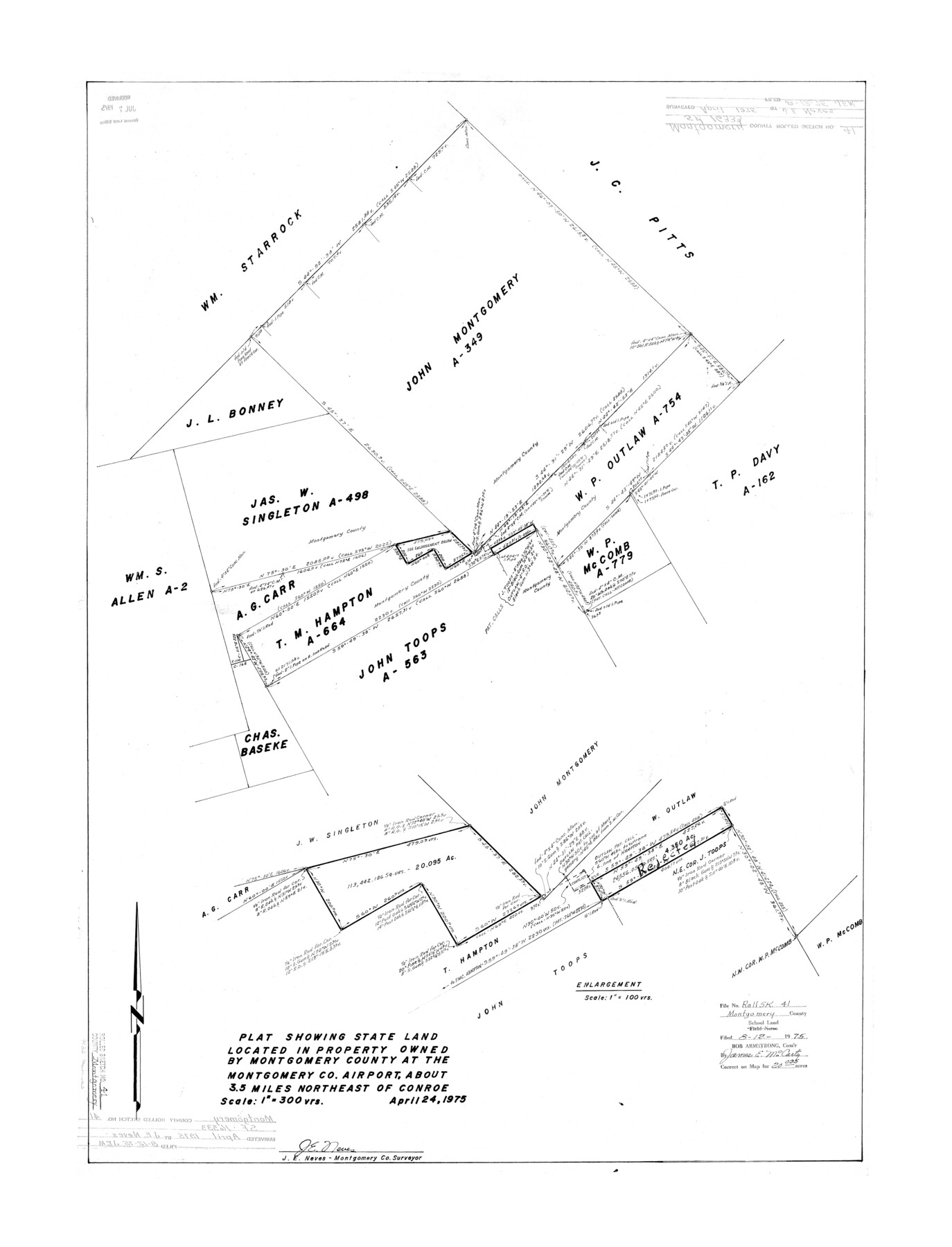
Montgomery County Rolled Sketch 41
Plat showing state land located in property owned by Montgomery County at the Montgomery Co. airport
-
Map/Doc
6814
-
Collection
General Map Collection
-
Object Dates
1975/4/24 (Creation Date)
1975/8/12 (File Date)
-
People and Organizations
J.E. Neves (Surveyor/Engineer)
-
Counties
Montgomery
-
Subjects
Surveying Rolled Sketch
-
Height x Width
35.2 x 26.8 inches
89.4 x 68.1 cm
-
Scale
1" = 300 varas
Part of: General Map Collection
Map of the State University & Public School Lands in Reeves and El Paso Cos.

Print $40.00
- Digital $50.00
Map of the State University & Public School Lands in Reeves and El Paso Cos.
1884
Size 39.1 x 56.3 inches
Map/Doc 2434
Intracoastal Waterway, Houma, LA to Corpus Christi, TX

Print $20.00
- Digital $50.00
Intracoastal Waterway, Houma, LA to Corpus Christi, TX
Size 18.9 x 27.9 inches
Map/Doc 61906

Hunt County Sketch File 14

Print $4.00
- Digital $50.00
Hunt County Sketch File 14
1851
Size 8.5 x 15.2 inches
Map/Doc 27107
Red River County Working Sketch 82

Print $20.00
- Digital $50.00
Red River County Working Sketch 82
1996
Size 21.9 x 30.6 inches
Map/Doc 72068
Louisiana and Texas Intracoastal Waterway - Gilchrist to Port Bolivar, Maintenance Dredging - Sheet 2

Print $20.00
- Digital $50.00
Louisiana and Texas Intracoastal Waterway - Gilchrist to Port Bolivar, Maintenance Dredging - Sheet 2
1937
Size 31.0 x 40.8 inches
Map/Doc 61821
Wood County Working Sketch 19

Print $20.00
- Digital $50.00
Wood County Working Sketch 19
1982
Size 25.8 x 24.8 inches
Map/Doc 62019
Webb County Sketch File 14-2

Print $6.00
- Digital $50.00
Webb County Sketch File 14-2
1936
Size 14.3 x 8.7 inches
Map/Doc 39817
Arlington Street Map & Guide

Digital $50.00
Arlington Street Map & Guide
Size 35.4 x 23.0 inches
Map/Doc 94437
[Sketch for Mineral Application 16700 - Pecos River Bed]
![2811, [Sketch for Mineral Application 16700 - Pecos River Bed], General Map Collection](https://historictexasmaps.com/wmedia_w700/maps/2811.tif.jpg)
Print $20.00
- Digital $50.00
[Sketch for Mineral Application 16700 - Pecos River Bed]
1927
Size 20.6 x 28.6 inches
Map/Doc 2811
Flight Mission No. DAG-23K, Frame 187, Matagorda County

Print $20.00
- Digital $50.00
Flight Mission No. DAG-23K, Frame 187, Matagorda County
1953
Size 17.5 x 22.4 inches
Map/Doc 86522
Menard County Working Sketch 20

Print $20.00
- Digital $50.00
Menard County Working Sketch 20
1947
Size 38.5 x 34.9 inches
Map/Doc 70967
You may also like
[Surveys along the Trinity River]
![330, [Surveys along the Trinity River], General Map Collection](https://historictexasmaps.com/wmedia_w700/maps/330.tif.jpg)
Print $2.00
- Digital $50.00
[Surveys along the Trinity River]
1846
Size 9.0 x 12.2 inches
Map/Doc 330
Working Sketch in Crockett County

Print $20.00
- Digital $50.00
Working Sketch in Crockett County
1923
Size 23.2 x 29.6 inches
Map/Doc 90315
Culberson County Sketch File WJ2

Print $20.00
- Digital $50.00
Culberson County Sketch File WJ2
Size 15.5 x 20.3 inches
Map/Doc 5788
Alamo Defenders Heritage Map of Texas

Print $20.00
Alamo Defenders Heritage Map of Texas
2025
Size 36.0 x 24.0 inches
Map/Doc 97433
Hutchinson County Rolled Sketch 8

Print $20.00
- Digital $50.00
Hutchinson County Rolled Sketch 8
Size 32.0 x 29.1 inches
Map/Doc 6279
Corpus Christi and Rio Grande Railway Company, [map showing the proposed railroad between Laredo and Corpus Christi and its connections with Mexico]
![93580, Corpus Christi and Rio Grande Railway Company, [map showing the proposed railroad between Laredo and Corpus Christi and its connections with Mexico], Library of Congress](https://historictexasmaps.com/wmedia_w700/maps/93580.tif.jpg)
Print $20.00
Corpus Christi and Rio Grande Railway Company, [map showing the proposed railroad between Laredo and Corpus Christi and its connections with Mexico]
1874
Size 14.6 x 24.0 inches
Map/Doc 93580
Harris County Sketch File 5

Print $20.00
- Digital $50.00
Harris County Sketch File 5
1858
Size 22.0 x 15.0 inches
Map/Doc 11648
Wilson County Rolled Sketch 3

Print $20.00
- Digital $50.00
Wilson County Rolled Sketch 3
1956
Size 25.8 x 22.8 inches
Map/Doc 8369
Henderson County Rolled Sketch 11

Print $20.00
- Digital $50.00
Henderson County Rolled Sketch 11
1915
Size 29.7 x 42.5 inches
Map/Doc 75951
Mineral Plats - El Paso to Ward Co. and River Beds

Mineral Plats - El Paso to Ward Co. and River Beds
Map/Doc 81746
Plat of All Surveys on the Lavaca Not Heretofor Returned

Print $2.00
- Digital $50.00
Plat of All Surveys on the Lavaca Not Heretofor Returned
1841
Size 12.5 x 7.8 inches
Map/Doc 78361
