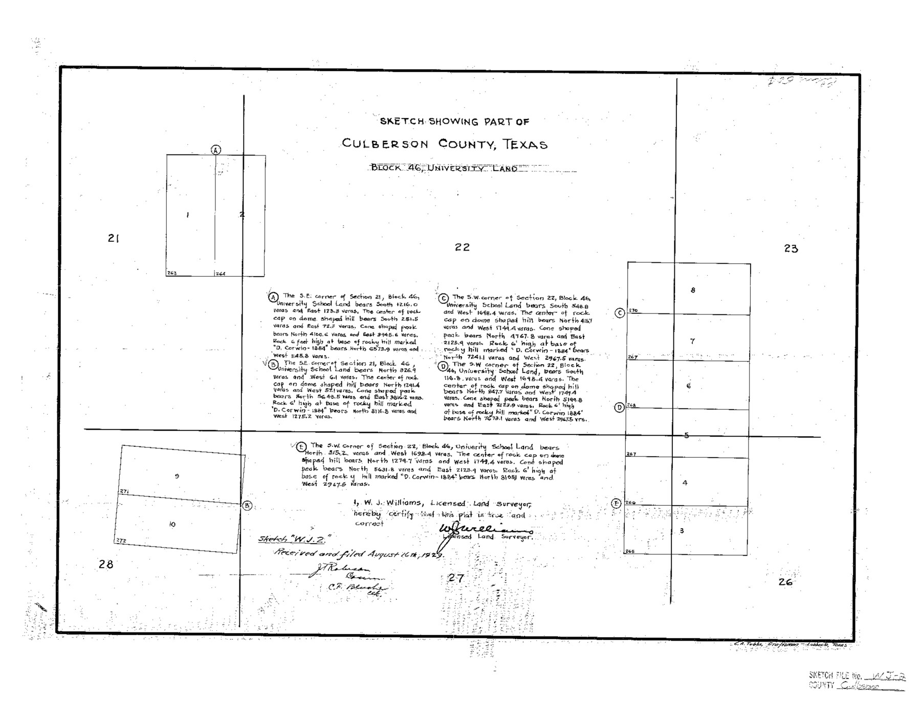
Culberson County Sketch File WJ2
Sketch Showing Part of Culberson County, Texas Block 46, University Land
-
Map/Doc
5788
-
Collection
General Map Collection
-
Object Dates
1929/8/16 (File Date)
-
People and Organizations
W.J. Williams (Surveyor/Engineer)
C.A. Tubbs (Draftsman)
-
Counties
Culberson
-
Subjects
Surveying Sketch File
-
Height x Width
15.5 x 20.3 inches
39.4 x 51.6 cm
-
Medium
paper, photocopy
Part of: General Map Collection
La Salle County Working Sketch 1

Print $20.00
- Digital $50.00
La Salle County Working Sketch 1
1929
Size 24.2 x 23.1 inches
Map/Doc 70302
Index for Texas Railroad ROW & track maps available on microfilm at THD & Archives and Records

Print $2.00
- Digital $50.00
Index for Texas Railroad ROW & track maps available on microfilm at THD & Archives and Records
1977
Size 11.2 x 8.8 inches
Map/Doc 60757
Duval County Sketch File 23

Print $4.00
- Digital $50.00
Duval County Sketch File 23
Size 8.1 x 7.1 inches
Map/Doc 21326
[Sketch for Mineral Application 26501 - Sabine River, T. A. Oldhausen]
![2844, [Sketch for Mineral Application 26501 - Sabine River, T. A. Oldhausen], General Map Collection](https://historictexasmaps.com/wmedia_w700/maps/2844.tif.jpg)
Print $20.00
- Digital $50.00
[Sketch for Mineral Application 26501 - Sabine River, T. A. Oldhausen]
1931
Size 24.4 x 36.8 inches
Map/Doc 2844
DeWitt County Working Sketch 9

Print $20.00
- Digital $50.00
DeWitt County Working Sketch 9
1979
Size 15.7 x 23.4 inches
Map/Doc 68599
Flight Mission No. DQN-2K, Frame 87, Calhoun County

Print $20.00
- Digital $50.00
Flight Mission No. DQN-2K, Frame 87, Calhoun County
1953
Size 18.9 x 22.6 inches
Map/Doc 84277
Menard County Boundary File 6

Print $6.00
- Digital $50.00
Menard County Boundary File 6
Size 11.2 x 8.7 inches
Map/Doc 57086
Dimmit County Working Sketch 4

Print $20.00
- Digital $50.00
Dimmit County Working Sketch 4
1911
Size 24.9 x 12.3 inches
Map/Doc 68665
El Paso County Sketch File 37

Print $4.00
- Digital $50.00
El Paso County Sketch File 37
1987
Size 14.4 x 9.1 inches
Map/Doc 22221
Intracoastal Waterway - Laguna Madre - Chubby Island to Stover Point including the Arroyo Colorado, Texas

Print $20.00
- Digital $50.00
Intracoastal Waterway - Laguna Madre - Chubby Island to Stover Point including the Arroyo Colorado, Texas
1976
Size 15.6 x 43.8 inches
Map/Doc 75900
Hood County Sketch File 18

Print $4.00
- Digital $50.00
Hood County Sketch File 18
Size 8.4 x 9.6 inches
Map/Doc 26601
Supplemental Plat, T. 4S., R. 14W., Indian Meridian, Oklahoma

Print $4.00
- Digital $50.00
Supplemental Plat, T. 4S., R. 14W., Indian Meridian, Oklahoma
1924
Size 17.4 x 23.1 inches
Map/Doc 75148
You may also like
General Highway Map, Dimmit County, La Salle County, Texas

Print $20.00
General Highway Map, Dimmit County, La Salle County, Texas
1940
Size 18.4 x 25.2 inches
Map/Doc 79077
Hutchinson County Sketch File 48

Print $38.00
- Digital $50.00
Hutchinson County Sketch File 48
1989
Size 11.2 x 8.8 inches
Map/Doc 27400
Real County Working Sketch 41

Print $20.00
- Digital $50.00
Real County Working Sketch 41
1952
Size 34.1 x 23.6 inches
Map/Doc 71933
Brazos Santiago, Texas

Print $20.00
- Digital $50.00
Brazos Santiago, Texas
1882
Size 18.3 x 26.1 inches
Map/Doc 72987

Stonewall County

Print $20.00
- Digital $50.00
Stonewall County
1888
Size 17.8 x 24.6 inches
Map/Doc 89055

[T.&P. Blocks 57 and 58, South to PSL Block 53]
![89763, [T.&P. Blocks 57 and 58, South to PSL Block 53], Twichell Survey Records](https://historictexasmaps.com/wmedia_w700/maps/89763-1.tif.jpg)
Print $40.00
- Digital $50.00
[T.&P. Blocks 57 and 58, South to PSL Block 53]
Size 30.5 x 68.7 inches
Map/Doc 89763

Map of the River Sabine from Logan's Ferry to 32nd degree of north latitude

Print $3.00
- Digital $50.00
Map of the River Sabine from Logan's Ferry to 32nd degree of north latitude
1841
Size 8.7 x 11.1 inches
Map/Doc 94497
San Jacinto County Sketch File A

Print $5.00
San Jacinto County Sketch File A
1895
Size 8.5 x 11.3 inches
Map/Doc 35716
Texas & Pacific R. R. through Pecos-Presidio Counties

Print $40.00
- Digital $50.00
Texas & Pacific R. R. through Pecos-Presidio Counties
Size 20.3 x 70.7 inches
Map/Doc 64282