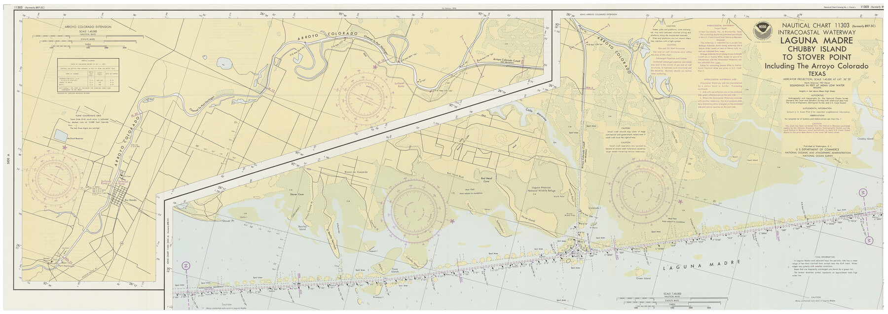
Intracoastal Waterway - Laguna Madre - Chubby Island to Stover Point including the Arroyo Colorado, Texas
-
Map/Doc
75900
-
Collection
General Map Collection
-
Object Dates
6/1976 (Creation Date)
-
Counties
Kenedy Willacy
-
Subjects
Nautical Charts
-
Height x Width
15.6 x 43.8 inches
39.6 x 111.3 cm
-
Comments
dual-sided map
Part of: General Map Collection
Flight Mission No. BRA-8M, Frame 70, Jefferson County

Print $20.00
- Digital $50.00
Flight Mission No. BRA-8M, Frame 70, Jefferson County
1953
Size 18.6 x 22.3 inches
Map/Doc 85590
Reagan County Working Sketch 9

Print $20.00
- Digital $50.00
Reagan County Working Sketch 9
1939
Size 12.4 x 24.2 inches
Map/Doc 71849
Bosque County Working Sketch 30

Print $20.00
- Digital $50.00
Bosque County Working Sketch 30
2009
Size 24.4 x 26.3 inches
Map/Doc 89066
Houston County Working Sketch 1

Print $20.00
- Digital $50.00
Houston County Working Sketch 1
Size 20.6 x 15.6 inches
Map/Doc 66231
Crane County Working Sketch 24

Print $20.00
- Digital $50.00
Crane County Working Sketch 24
1966
Size 28.7 x 33.3 inches
Map/Doc 68301
Cameron County Rolled Sketch 7A

Print $20.00
- Digital $50.00
Cameron County Rolled Sketch 7A
1926
Size 30.2 x 34.0 inches
Map/Doc 5384
Hardin County Sketch File 50

Print $5.00
- Digital $50.00
Hardin County Sketch File 50
Size 13.5 x 9.2 inches
Map/Doc 25204
Hamilton County Sketch File 13

Print $40.00
- Digital $50.00
Hamilton County Sketch File 13
1876
Size 12.0 x 16.7 inches
Map/Doc 24935
Galveston County Rolled Sketch 44

Print $20.00
- Digital $50.00
Galveston County Rolled Sketch 44
1991
Size 25.1 x 36.8 inches
Map/Doc 5974
Panola County Rolled Sketch 5

Print $40.00
- Digital $50.00
Panola County Rolled Sketch 5
Size 81.0 x 33.1 inches
Map/Doc 9678
Jackson County Rolled Sketch 3C

Print $59.00
- Digital $50.00
Jackson County Rolled Sketch 3C
1913
Size 23.7 x 21.8 inches
Map/Doc 6339
Bailey County Rolled Sketch 6

Print $20.00
- Digital $50.00
Bailey County Rolled Sketch 6
Size 17.4 x 12.9 inches
Map/Doc 5111
You may also like
Map of Jack County

Print $20.00
- Digital $50.00
Map of Jack County
1882
Size 21.6 x 24.5 inches
Map/Doc 3706
Brown County Working Sketch 15

Print $20.00
- Digital $50.00
Brown County Working Sketch 15
1989
Size 23.6 x 16.7 inches
Map/Doc 67780
The Coast of Texas

Print $20.00
- Digital $50.00
The Coast of Texas
1844
Size 18.2 x 27.0 inches
Map/Doc 72700
Sabine and Neches Rivers

Print $20.00
- Digital $50.00
Sabine and Neches Rivers
1987
Size 19.6 x 44.7 inches
Map/Doc 69820
Chambers County NRC Article 33.136 Sketch 14

Print $42.00
- Digital $50.00
Chambers County NRC Article 33.136 Sketch 14
Size 34.5 x 22.6 inches
Map/Doc 97016
Uvalde County Rolled Sketch 10

Print $20.00
- Digital $50.00
Uvalde County Rolled Sketch 10
Size 23.5 x 16.1 inches
Map/Doc 8095

Plat of Surveys in Hidalgo Co.

Print $20.00
- Digital $50.00
Plat of Surveys in Hidalgo Co.
Size 18.3 x 9.2 inches
Map/Doc 75548
Atascosa County Sketch File 22

Print $6.00
- Digital $50.00
Atascosa County Sketch File 22
Size 14.2 x 8.6 inches
Map/Doc 13789
Newton County

Print $20.00
- Digital $50.00
Newton County
1946
Size 46.8 x 40.9 inches
Map/Doc 77383
Eastland County Working Sketch 31

Print $20.00
- Digital $50.00
Eastland County Working Sketch 31
1955
Size 33.9 x 33.9 inches
Map/Doc 68812
La Salle County Working Sketch 9

Print $20.00
- Digital $50.00
La Salle County Working Sketch 9
1925
Size 21.2 x 15.6 inches
Map/Doc 70310