Menard County Boundary File 6
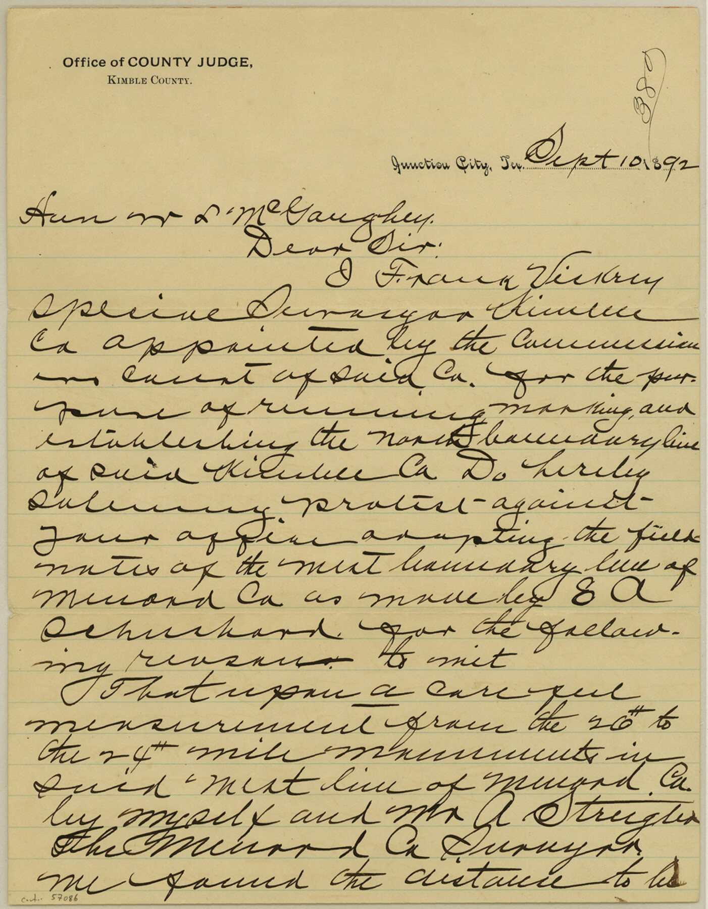
Protest by Frank Vickrey Special Surveyor
-
Map/Doc
57086
-
Collection
General Map Collection
-
Counties
Menard
-
Subjects
County Boundaries
-
Height x Width
11.2 x 8.7 inches
28.5 x 22.1 cm
Part of: General Map Collection
Hartley County

Print $40.00
- Digital $50.00
Hartley County
1902
Size 44.5 x 58.0 inches
Map/Doc 2480
Val Verde County Working Sketch 48

Print $20.00
- Digital $50.00
Val Verde County Working Sketch 48
1949
Size 32.6 x 17.6 inches
Map/Doc 72183
Presidio County Sketch File 104

Print $17.00
- Digital $50.00
Presidio County Sketch File 104
Size 11.3 x 8.7 inches
Map/Doc 34807
Flight Mission No. BRE-2P, Frame 107, Nueces County

Print $20.00
- Digital $50.00
Flight Mission No. BRE-2P, Frame 107, Nueces County
1956
Size 18.5 x 22.7 inches
Map/Doc 86792
Reeves County Sketch File 11

Print $20.00
- Digital $50.00
Reeves County Sketch File 11
1891
Size 20.1 x 17.9 inches
Map/Doc 12245
San Augustine County Sketch File 14

Print $22.00
San Augustine County Sketch File 14
1888
Size 13.2 x 12.6 inches
Map/Doc 35662
Liberty County Working Sketch 89

Print $20.00
- Digital $50.00
Liberty County Working Sketch 89
1993
Size 45.0 x 26.2 inches
Map/Doc 70549
Right of Way and Track Map, the Missouri, Kansas & Texas Ry. Of Texas operated by the Missouri, Kansas & Texas Ry. Of Texas, Houston Division

Print $40.00
- Digital $50.00
Right of Way and Track Map, the Missouri, Kansas & Texas Ry. Of Texas operated by the Missouri, Kansas & Texas Ry. Of Texas, Houston Division
1918
Size 25.6 x 62.5 inches
Map/Doc 64786
Corpus Christi Pass

Print $20.00
- Digital $50.00
Corpus Christi Pass
Size 45.7 x 41.2 inches
Map/Doc 78454
Jefferson County Rolled Sketch 21

Print $20.00
- Digital $50.00
Jefferson County Rolled Sketch 21
Size 12.0 x 12.1 inches
Map/Doc 6387
Sabine Bank to East Bay including Heald Bank

Print $20.00
- Digital $50.00
Sabine Bank to East Bay including Heald Bank
1982
Size 44.8 x 34.3 inches
Map/Doc 69852
Wichita County Working Sketch 14

Print $20.00
- Digital $50.00
Wichita County Working Sketch 14
1922
Size 20.8 x 42.1 inches
Map/Doc 72524
You may also like
Henderson County Rolled Sketch 11

Print $20.00
- Digital $50.00
Henderson County Rolled Sketch 11
1915
Size 29.4 x 42.6 inches
Map/Doc 75955
Travis County Appraisal District Plat Map 2_0805

Print $20.00
- Digital $50.00
Travis County Appraisal District Plat Map 2_0805
Size 21.4 x 26.4 inches
Map/Doc 94231
Hunt County Sketch File 35

Print $4.00
- Digital $50.00
Hunt County Sketch File 35
Size 5.3 x 8.3 inches
Map/Doc 27148
General Highway Map. Detail of Cities and Towns in Grayson County, Texas [Denison and Sherman]
![79487, General Highway Map. Detail of Cities and Towns in Grayson County, Texas [Denison and Sherman], Texas State Library and Archives](https://historictexasmaps.com/wmedia_w700/maps/79487.tif.jpg)
Print $20.00
General Highway Map. Detail of Cities and Towns in Grayson County, Texas [Denison and Sherman]
1961
Size 18.2 x 24.6 inches
Map/Doc 79487
Brazoria County Rolled Sketch 29

Print $20.00
- Digital $50.00
Brazoria County Rolled Sketch 29
1931
Size 41.4 x 29.1 inches
Map/Doc 5167
Deaf Smith County, Texas

Print $20.00
- Digital $50.00
Deaf Smith County, Texas
1880
Size 22.9 x 25.6 inches
Map/Doc 678
Archer County Rolled Sketch E

Print $20.00
- Digital $50.00
Archer County Rolled Sketch E
Size 34.3 x 37.2 inches
Map/Doc 8424
Culberson County Sketch File 5a

Print $44.00
- Digital $50.00
Culberson County Sketch File 5a
Size 14.2 x 8.8 inches
Map/Doc 20169
Hall County Sketch File 30

Print $6.00
- Digital $50.00
Hall County Sketch File 30
1942
Size 11.3 x 8.9 inches
Map/Doc 24832
Falls County Sketch File 17

Print $6.00
- Digital $50.00
Falls County Sketch File 17
1872
Size 8.4 x 13.1 inches
Map/Doc 22377
Coleman County Sketch File 36

Print $20.00
- Digital $50.00
Coleman County Sketch File 36
1878
Size 24.5 x 30.8 inches
Map/Doc 11122
Sutton County Working Sketch 5

Print $20.00
- Digital $50.00
Sutton County Working Sketch 5
1969
Size 25.4 x 33.4 inches
Map/Doc 62348