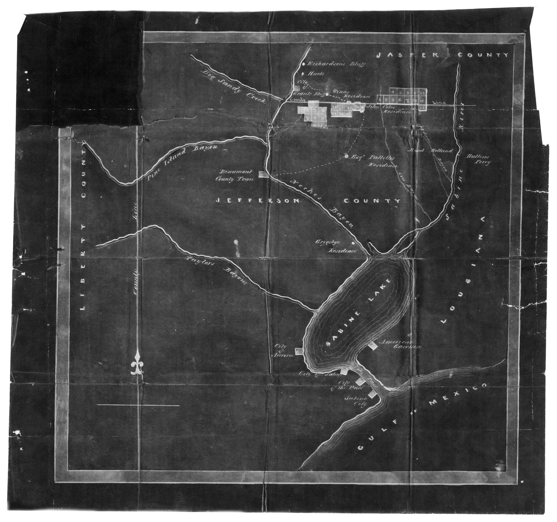
Jefferson County Rolled Sketch 21
[Old sketch of Sabine Lake and bayous]
-
Map/Doc
6387
-
Collection
General Map Collection
-
Object Dates
9/21/1932 (File Date)
-
Counties
Jefferson
-
Subjects
Surveying Rolled Sketch
-
Height x Width
12.0 x 12.1 inches
30.5 x 30.7 cm
-
Medium
photostat
Part of: General Map Collection
Henderson County Working Sketch 33

Print $20.00
- Digital $50.00
Henderson County Working Sketch 33
1963
Size 31.2 x 29.3 inches
Map/Doc 66166
Presidio County Sketch File 87

Print $6.00
- Digital $50.00
Presidio County Sketch File 87
1951
Size 14.5 x 8.7 inches
Map/Doc 34748
Zavala County Sketch File 34

Print $4.00
- Digital $50.00
Zavala County Sketch File 34
1887
Size 13.0 x 8.5 inches
Map/Doc 41395
Kinney County Sketch File 26

Print $20.00
- Digital $50.00
Kinney County Sketch File 26
1928
Size 20.4 x 18.8 inches
Map/Doc 11945

Dallam County Sketch File 10

Print $20.00
- Digital $50.00
Dallam County Sketch File 10
1925
Size 7.2 x 8.6 inches
Map/Doc 20367
Starr County Working Sketch 23

Print $20.00
- Digital $50.00
Starr County Working Sketch 23
1984
Size 29.9 x 30.6 inches
Map/Doc 63939
Brooks County Rolled Sketch 16

Print $20.00
- Digital $50.00
Brooks County Rolled Sketch 16
1941
Size 18.0 x 18.8 inches
Map/Doc 5341

Maps of Gulf Intracoastal Waterway, Texas - Sabine River to the Rio Grande and connecting waterways including ship channels

Print $20.00
- Digital $50.00
Maps of Gulf Intracoastal Waterway, Texas - Sabine River to the Rio Grande and connecting waterways including ship channels
1966
Size 14.6 x 22.4 inches
Map/Doc 61924
San Patricio County Working Sketch 19

Print $20.00
- Digital $50.00
San Patricio County Working Sketch 19
1956
Size 36.1 x 41.3 inches
Map/Doc 63781
Baylor County Boundary File 13

Print $44.00
- Digital $50.00
Baylor County Boundary File 13
Size 4.3 x 9.7 inches
Map/Doc 50424
You may also like
Jones Subdivision of Sections 28 and 32, Block "A' and Section 2, Block "D3"

Print $2.00
- Digital $50.00
Jones Subdivision of Sections 28 and 32, Block "A' and Section 2, Block "D3"
1928
Size 8.7 x 8.7 inches
Map/Doc 92708
El Paso County Boundary File 7a

Print $20.00
- Digital $50.00
El Paso County Boundary File 7a
Size 14.2 x 8.3 inches
Map/Doc 53094
Burnet County Boundary File 6

Print $14.00
- Digital $50.00
Burnet County Boundary File 6
Size 14.1 x 8.6 inches
Map/Doc 50886
Brazoria County Aerial Photograph Index Sheet 6

Print $20.00
- Digital $50.00
Brazoria County Aerial Photograph Index Sheet 6
1953
Size 23.8 x 19.3 inches
Map/Doc 83668
[Right of Way Map, Belton Branch of the M.K.&T. RR.]
![64222, [Right of Way Map, Belton Branch of the M.K.&T. RR.], General Map Collection](https://historictexasmaps.com/wmedia_w700/maps/64222.tif.jpg)
Print $20.00
- Digital $50.00
[Right of Way Map, Belton Branch of the M.K.&T. RR.]
1896
Size 21.9 x 7.4 inches
Map/Doc 64222
Guadalupe County Sketch File 8

Print $7.00
- Digital $50.00
Guadalupe County Sketch File 8
1871
Size 10.4 x 8.3 inches
Map/Doc 24674
Randall County Boundary File 3

Print $8.00
- Digital $50.00
Randall County Boundary File 3
Size 14.3 x 8.8 inches
Map/Doc 58125
Flight Mission No. CLL-1N, Frame 159, Willacy County

Print $20.00
- Digital $50.00
Flight Mission No. CLL-1N, Frame 159, Willacy County
1954
Size 18.4 x 22.2 inches
Map/Doc 87050
Map of the Lands Surveyed by the Memphis, El Paso & Pacific R.R. Company

Print $20.00
- Digital $50.00
Map of the Lands Surveyed by the Memphis, El Paso & Pacific R.R. Company
1859
Size 19.7 x 23.3 inches
Map/Doc 4847
Copy of Surveyor's Field Book, Morris Browning - In Blocks 7, 5 & 4, I&GNRRCo., Hutchinson and Carson Counties, Texas

Print $2.00
- Digital $50.00
Copy of Surveyor's Field Book, Morris Browning - In Blocks 7, 5 & 4, I&GNRRCo., Hutchinson and Carson Counties, Texas
1888
Size 6.9 x 8.8 inches
Map/Doc 62260
Cochran County Working Sketch 1

Print $20.00
- Digital $50.00
Cochran County Working Sketch 1
1940
Size 21.1 x 35.9 inches
Map/Doc 68012
[Maps of surveys in Reeves & Culberson Cos]
![61139, [Maps of surveys in Reeves & Culberson Cos], General Map Collection](https://historictexasmaps.com/wmedia_w700/maps/61139.tif.jpg)
Print $20.00
- Digital $50.00
[Maps of surveys in Reeves & Culberson Cos]
1937
Size 30.7 x 24.7 inches
Map/Doc 61139