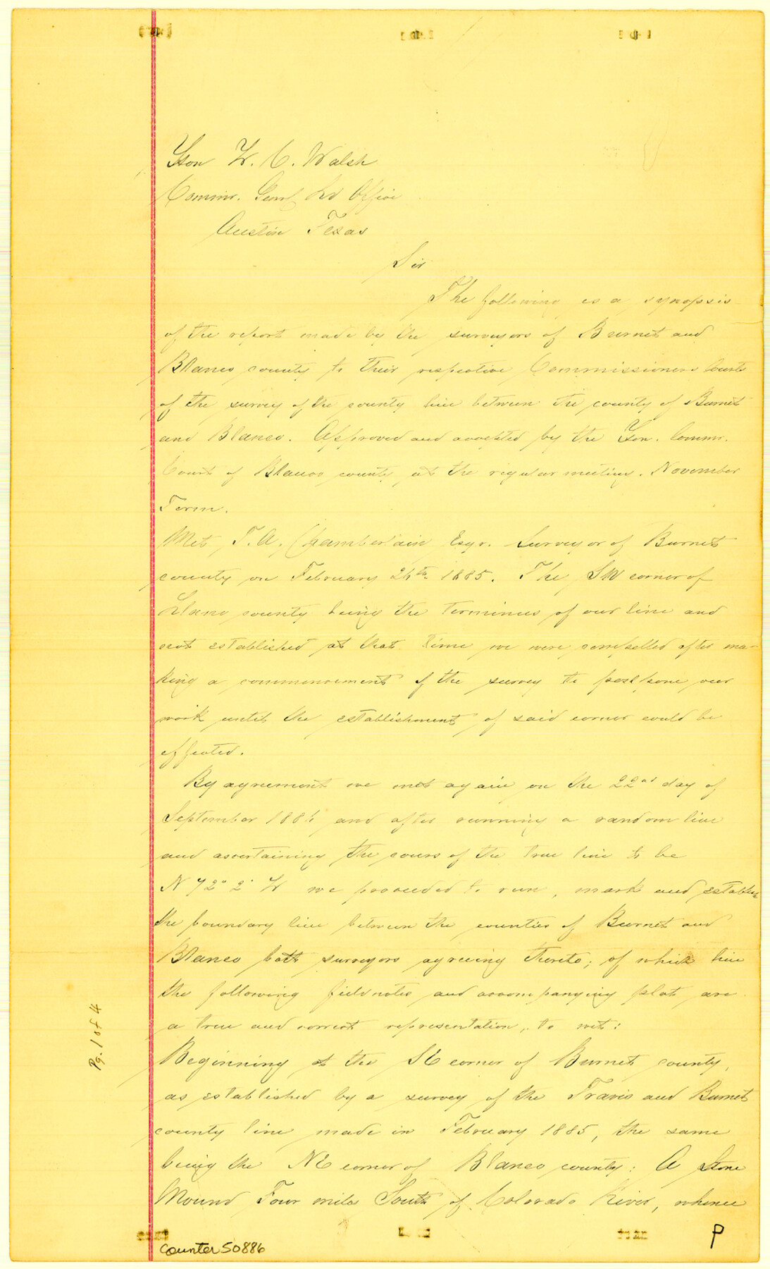
Burnet County Boundary File 6
County Boundary Line Between the Counties of Burnet & Blanco
-
Map/Doc
50886
-
Collection
General Map Collection
-
Counties
Burnet
-
Subjects
County Boundaries
-
Height x Width
14.1 x 8.6 inches
35.8 x 21.8 cm
Part of: General Map Collection
Liberty County Rolled Sketch O

Print $40.00
- Digital $50.00
Liberty County Rolled Sketch O
1954
Size 52.3 x 42.8 inches
Map/Doc 10720
Limestone County Working Sketch 4

Print $20.00
- Digital $50.00
Limestone County Working Sketch 4
1921
Size 20.2 x 26.3 inches
Map/Doc 70554
Maverick County Working Sketch 23

Print $20.00
- Digital $50.00
Maverick County Working Sketch 23
1985
Size 37.8 x 36.4 inches
Map/Doc 70915
Frio County Working Sketch 20

Print $20.00
- Digital $50.00
Frio County Working Sketch 20
1985
Size 36.3 x 36.0 inches
Map/Doc 69294
Duval County Rolled Sketch 37

Print $20.00
- Digital $50.00
Duval County Rolled Sketch 37
1952
Size 29.2 x 24.6 inches
Map/Doc 5753
Brewster County Rolled Sketch 93

Print $20.00
- Digital $50.00
Brewster County Rolled Sketch 93
1935
Size 24.1 x 43.1 inches
Map/Doc 5251
Flight Mission No. CUG-1P, Frame 55, Kleberg County

Print $20.00
- Digital $50.00
Flight Mission No. CUG-1P, Frame 55, Kleberg County
1956
Size 18.5 x 22.3 inches
Map/Doc 86133
Wise County Working Sketch 16

Print $20.00
- Digital $50.00
Wise County Working Sketch 16
1960
Size 28.0 x 39.0 inches
Map/Doc 72630
Armstrong County Sketch File 5

Print $40.00
- Digital $50.00
Armstrong County Sketch File 5
1887
Size 19.7 x 22.9 inches
Map/Doc 10841
Map of Corpus Christi Bay in Nueces County Showing Subdivision Thereof for Mineral Development

Print $40.00
- Digital $50.00
Map of Corpus Christi Bay in Nueces County Showing Subdivision Thereof for Mineral Development
1946
Size 55.9 x 43.3 inches
Map/Doc 2942

Wood County Sketch File 6

Print $8.00
- Digital $50.00
Wood County Sketch File 6
1877
Size 8.2 x 5.4 inches
Map/Doc 40641
You may also like
Map of the Missouri, Kansas and Texas Railway and connecting lines

Print $20.00
- Digital $50.00
Map of the Missouri, Kansas and Texas Railway and connecting lines
1889
Size 17.7 x 32.1 inches
Map/Doc 95806
Flight Mission No. DAG-19K, Frame 62, Matagorda County

Print $20.00
- Digital $50.00
Flight Mission No. DAG-19K, Frame 62, Matagorda County
1952
Size 16.2 x 16.1 inches
Map/Doc 86389
John H. Stephens Block S2, State Capitol Leagues

Print $20.00
- Digital $50.00
John H. Stephens Block S2, State Capitol Leagues
Size 28.6 x 23.2 inches
Map/Doc 92995
Dallas County Boundary File 6g

Print $6.00
- Digital $50.00
Dallas County Boundary File 6g
Size 11.2 x 8.7 inches
Map/Doc 52275
Kimble County Sketch File 10

Print $23.00
- Digital $50.00
Kimble County Sketch File 10
Size 18.5 x 15.6 inches
Map/Doc 28931
Harris County Historic Topographic 26

Print $20.00
- Digital $50.00
Harris County Historic Topographic 26
1916
Size 29.2 x 22.8 inches
Map/Doc 65837
Harris County Sketch File 75

Print $4.00
- Digital $50.00
Harris County Sketch File 75
1948
Size 11.7 x 9.0 inches
Map/Doc 25544
Brewster County Rolled Sketch 89

Print $40.00
- Digital $50.00
Brewster County Rolled Sketch 89
1947
Size 37.3 x 63.4 inches
Map/Doc 8499
Kansas Pacific Railway: The Best and Shortest Cattle Route from Texas

Print $20.00
Kansas Pacific Railway: The Best and Shortest Cattle Route from Texas
1872
Size 21.4 x 16.3 inches
Map/Doc 94453
Nueces County Rolled Sketch 128

Print $20.00
- Digital $50.00
Nueces County Rolled Sketch 128
1998
Size 18.3 x 24.5 inches
Map/Doc 7163
Val Verde County Sketch File 28

Print $20.00
- Digital $50.00
Val Verde County Sketch File 28
Size 29.9 x 25.1 inches
Map/Doc 12573
Bosque County Working Sketch 27

Print $20.00
- Digital $50.00
Bosque County Working Sketch 27
2006
Size 29.8 x 38.0 inches
Map/Doc 85241