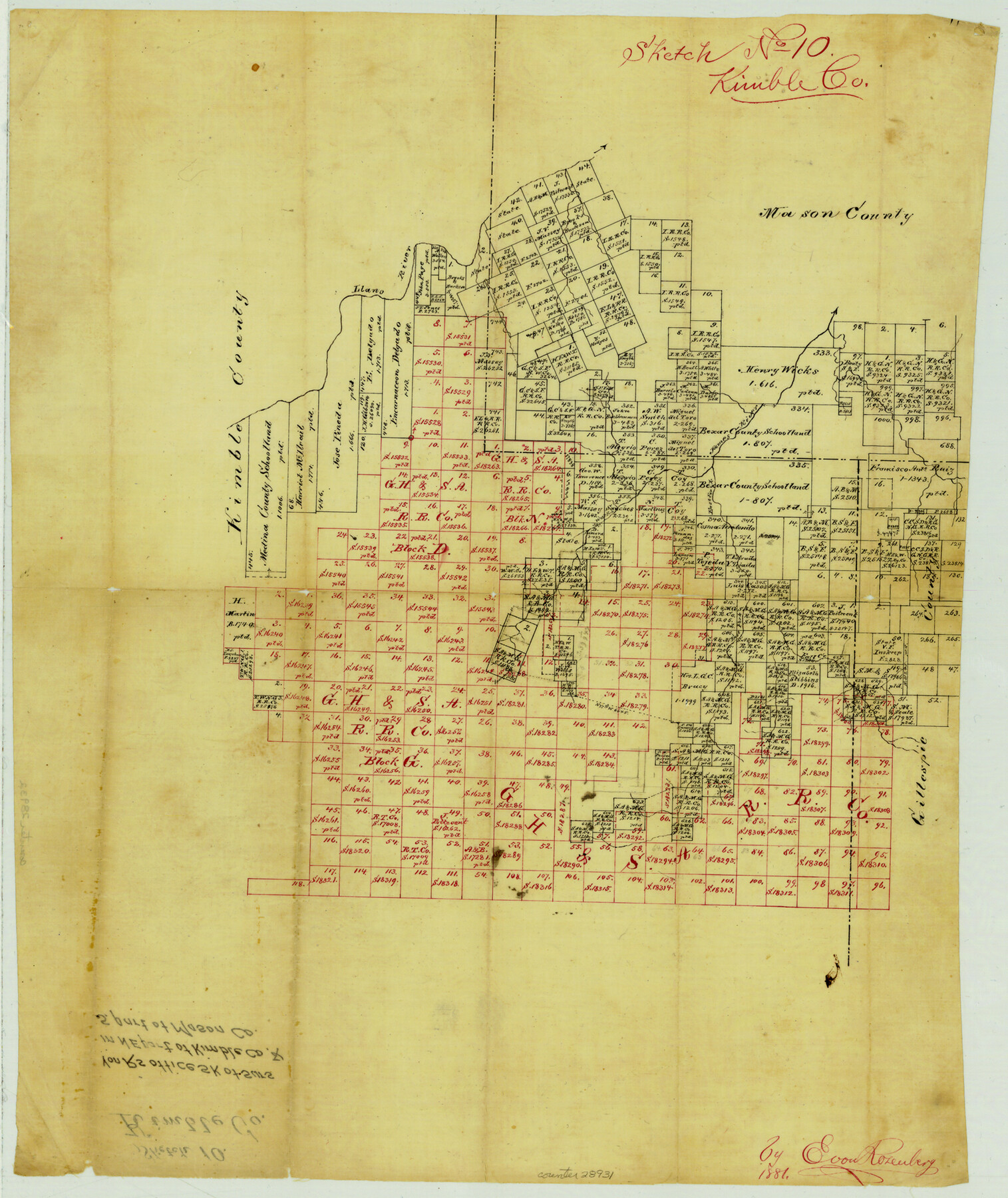
Kimble County Sketch File 10
[Office sketch of surveys in east part of Kimble County and southwest part of Mason County]
-
Map/Doc
28931
-
Collection
General Map Collection
-
People and Organizations
E. von Rosenberg (Draftsman)
-
Counties
Kimble Mason Gillespie
-
Subjects
Surveying Sketch File
-
Height x Width
18.5 x 15.6 inches
47.0 x 39.6 cm
-
Medium
paper, manuscript
-
Features
Llano River
James River
Part of: General Map Collection
Rockwall County

Print $20.00
- Digital $50.00
Rockwall County
1941
Size 28.7 x 23.0 inches
Map/Doc 73277
Runnels County Working Sketch 3

Print $20.00
- Digital $50.00
Runnels County Working Sketch 3
1888
Size 22.1 x 20.3 inches
Map/Doc 63599
Henderson County Working Sketch 35

Print $20.00
- Digital $50.00
Henderson County Working Sketch 35
1963
Size 19.3 x 38.1 inches
Map/Doc 66168
Brewster County Rolled Sketch 144A

Print $40.00
- Digital $50.00
Brewster County Rolled Sketch 144A
Size 53.4 x 43.5 inches
Map/Doc 9195
Flight Mission No. BQR-20K, Frame 13, Brazoria County

Print $20.00
- Digital $50.00
Flight Mission No. BQR-20K, Frame 13, Brazoria County
1952
Size 18.6 x 22.3 inches
Map/Doc 84115
Webb County Rolled Sketch 38

Print $20.00
- Digital $50.00
Webb County Rolled Sketch 38
1940
Size 22.2 x 16.0 inches
Map/Doc 8193
Coryell County Sketch File 2

Print $4.00
- Digital $50.00
Coryell County Sketch File 2
Size 13.0 x 8.0 inches
Map/Doc 19338
[Surveys along the Sabine River made under G.W. Smyth, Commissioner]
![90, [Surveys along the Sabine River made under G.W. Smyth, Commissioner], General Map Collection](https://historictexasmaps.com/wmedia_w700/maps/90.tif.jpg)
Print $20.00
- Digital $50.00
[Surveys along the Sabine River made under G.W. Smyth, Commissioner]
1837
Size 13.9 x 17.0 inches
Map/Doc 90
Subdivision of the W.W. Arrington Tract situated 3 miles west of Clinton in DeWitt County, Texas owned by Hugh F. McKenna, Esqr., New Orleans

Print $20.00
- Digital $50.00
Subdivision of the W.W. Arrington Tract situated 3 miles west of Clinton in DeWitt County, Texas owned by Hugh F. McKenna, Esqr., New Orleans
Size 23.6 x 16.7 inches
Map/Doc 94242
Hardin County Sketch File 66

Print $20.00
- Digital $50.00
Hardin County Sketch File 66
1948
Size 19.5 x 35.8 inches
Map/Doc 11639
United States

Print $20.00
- Digital $50.00
United States
1838
Size 12.2 x 19.6 inches
Map/Doc 97099
Zavala County Working Sketch 10

Print $20.00
- Digital $50.00
Zavala County Working Sketch 10
1954
Size 30.4 x 38.8 inches
Map/Doc 62085
You may also like
Montague County Working Sketch Graphic Index

Print $20.00
- Digital $50.00
Montague County Working Sketch Graphic Index
1924
Size 45.3 x 33.2 inches
Map/Doc 76645
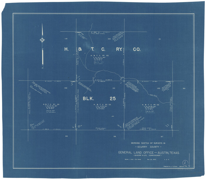
Scurry County Working Sketch 4
Print $20.00
- Digital $50.00
Scurry County Working Sketch 4
1944
Size 23.1 x 26.5 inches
Map/Doc 63833
Sherman County Rolled Sketch 6

Print $20.00
- Digital $50.00
Sherman County Rolled Sketch 6
1919
Size 37.3 x 36.0 inches
Map/Doc 10731
Map of Tom Green County

Print $20.00
- Digital $50.00
Map of Tom Green County
1892
Size 44.0 x 45.1 inches
Map/Doc 63068
Travis County Rolled Sketch 13

Print $20.00
- Digital $50.00
Travis County Rolled Sketch 13
Size 28.0 x 20.4 inches
Map/Doc 8016
Harrison County Sketch File 18

Print $20.00
- Digital $50.00
Harrison County Sketch File 18
1954
Size 23.2 x 26.9 inches
Map/Doc 11691
Flight Mission No. DQN-1K, Frame 123, Calhoun County

Print $20.00
- Digital $50.00
Flight Mission No. DQN-1K, Frame 123, Calhoun County
1953
Size 18.4 x 22.2 inches
Map/Doc 84189
Wise County Sketch File 43

Print $4.00
- Digital $50.00
Wise County Sketch File 43
1876
Size 8.3 x 12.8 inches
Map/Doc 40603
Motley County Boundary File 1a

Print $8.00
- Digital $50.00
Motley County Boundary File 1a
Size 11.2 x 8.5 inches
Map/Doc 57501
Henderson County Working Sketch 34

Print $20.00
- Digital $50.00
Henderson County Working Sketch 34
1965
Size 22.9 x 35.8 inches
Map/Doc 66167
[Sketch of Survey 9, Block Z3]
![93089, [Sketch of Survey 9, Block Z3], Twichell Survey Records](https://historictexasmaps.com/wmedia_w700/maps/93089-1.tif.jpg)
Print $2.00
- Digital $50.00
[Sketch of Survey 9, Block Z3]
Size 8.9 x 7.3 inches
Map/Doc 93089
Hardin County Working Sketch 20

Print $20.00
- Digital $50.00
Hardin County Working Sketch 20
1947
Size 38.1 x 32.6 inches
Map/Doc 63418