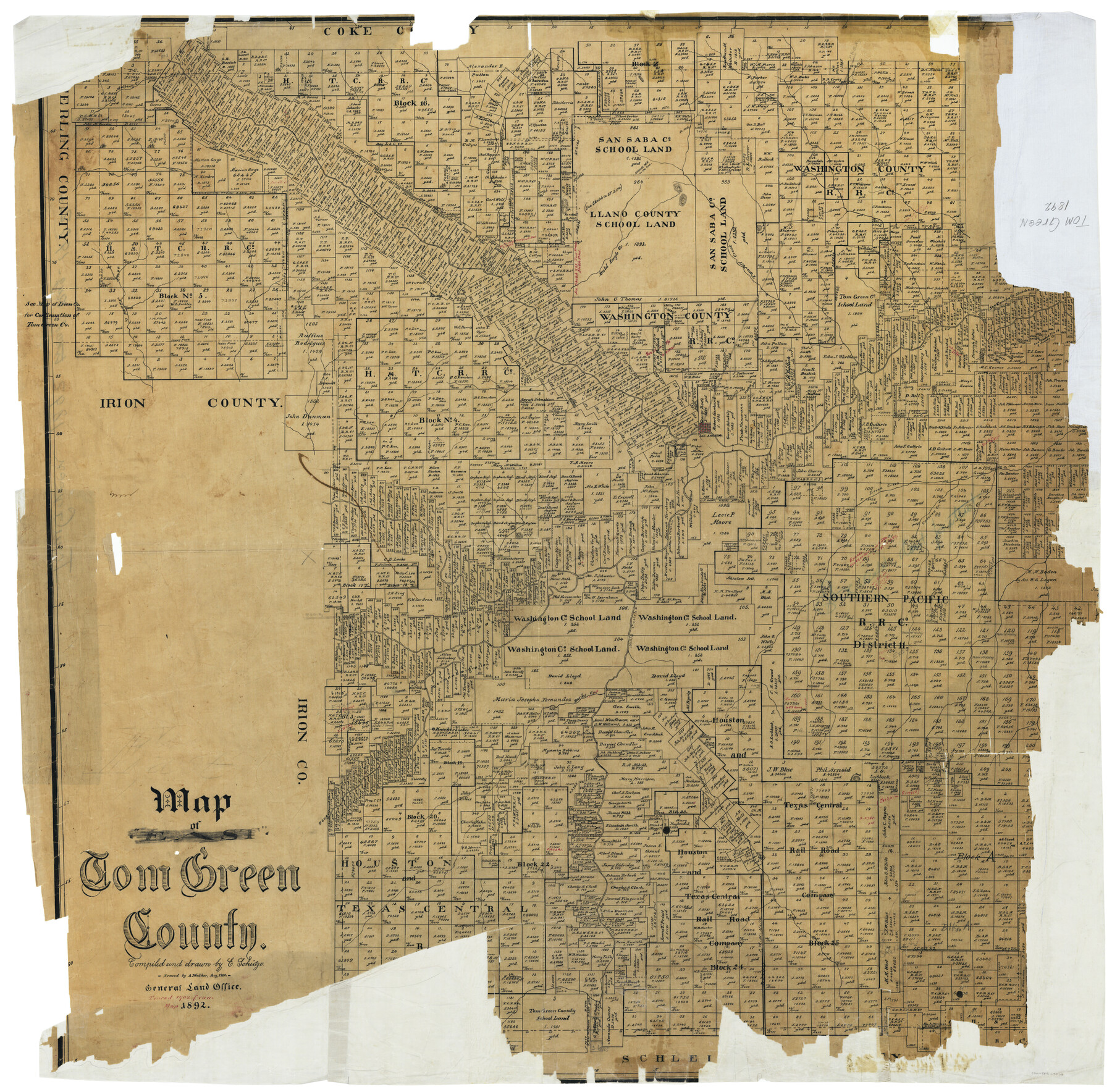
Map of Tom Green County
-
Map/Doc
63068
-
Collection
General Map Collection
-
Object Dates
1892 (Creation Date)
-
People and Organizations
Ed. Schutze (Draftsman)
-
Counties
Tom Green
-
Subjects
County
-
Height x Width
44.0 x 45.1 inches
111.8 x 114.6 cm
-
Comments
Traced in August 1902 by A. Walker.
Part of: General Map Collection
Webb County Working Sketch 48

Print $20.00
- Digital $50.00
Webb County Working Sketch 48
1948
Size 28.5 x 41.4 inches
Map/Doc 72413
Flight Mission No. DQN-2K, Frame 87, Calhoun County

Print $20.00
- Digital $50.00
Flight Mission No. DQN-2K, Frame 87, Calhoun County
1953
Size 18.9 x 22.6 inches
Map/Doc 84277
Madison County Working Sketch 9

Print $20.00
- Digital $50.00
Madison County Working Sketch 9
1982
Size 15.7 x 21.1 inches
Map/Doc 70771
[Map of Texas and Pacific Blocks from Brazos River westward through Palo Pinto, Stephens, Shackelford, Jones, Callahan, Taylor, Fisher, Nolan and Mitchell Counties]
![93456, [Map of Texas and Pacific Blocks from Brazos River westward through Palo Pinto, Stephens, Shackelford, Jones, Callahan, Taylor, Fisher, Nolan and Mitchell Counties], General Map Collection](https://historictexasmaps.com/wmedia_w700/maps/93456-1.tif.jpg)
Print $20.00
- Digital $50.00
[Map of Texas and Pacific Blocks from Brazos River westward through Palo Pinto, Stephens, Shackelford, Jones, Callahan, Taylor, Fisher, Nolan and Mitchell Counties]
Size 22.0 x 18.5 inches
Map/Doc 93456
Layout of the porciones as described in the Visita General of Mier, 1767

Layout of the porciones as described in the Visita General of Mier, 1767
2009
Size 11.0 x 8.5 inches
Map/Doc 94043
Flight Mission No. BRA-16M, Frame 161, Jefferson County

Print $20.00
- Digital $50.00
Flight Mission No. BRA-16M, Frame 161, Jefferson County
1953
Size 18.5 x 22.3 inches
Map/Doc 85759
Jackson County Sketch File 9

Print $24.00
- Digital $50.00
Jackson County Sketch File 9
1898
Size 11.3 x 8.8 inches
Map/Doc 27651
Hardin County Sketch File 45

Print $2.00
- Digital $50.00
Hardin County Sketch File 45
Size 8.3 x 6.2 inches
Map/Doc 25195
Railroad Track Map, H&TCRRCo., Falls County, Texas

Print $4.00
- Digital $50.00
Railroad Track Map, H&TCRRCo., Falls County, Texas
1918
Size 11.6 x 18.6 inches
Map/Doc 62834

Duval County Working Sketch 31

Print $20.00
- Digital $50.00
Duval County Working Sketch 31
1950
Size 29.1 x 34.0 inches
Map/Doc 68755
Jefferson County Working Sketch 13

Print $20.00
- Digital $50.00
Jefferson County Working Sketch 13
1948
Size 13.5 x 20.1 inches
Map/Doc 66556
You may also like
Mason County Sketch File 1

Print $6.00
- Digital $50.00
Mason County Sketch File 1
1857
Size 11.0 x 8.2 inches
Map/Doc 30677
Flight Mission No. BQY-4M, Frame 124, Harris County

Print $20.00
- Digital $50.00
Flight Mission No. BQY-4M, Frame 124, Harris County
1953
Size 18.7 x 22.4 inches
Map/Doc 85292
[T. & G. Ry. Main Line, Texas, Right of Way Map, Center to Gary]
![64572, [T. & G. Ry. Main Line, Texas, Right of Way Map, Center to Gary], General Map Collection](https://historictexasmaps.com/wmedia_w700/maps/64572-1.tif.jpg)
Print $40.00
- Digital $50.00
[T. & G. Ry. Main Line, Texas, Right of Way Map, Center to Gary]
1917
Size 31.9 x 104.6 inches
Map/Doc 64572
Limestone County

Print $40.00
- Digital $50.00
Limestone County
1922
Size 50.6 x 36.2 inches
Map/Doc 73342
[El Javali Grant,] Sketch of 2560 acres of land in Starr County
![474, [El Javali Grant,] Sketch of 2560 acres of land in Starr County, Maddox Collection](https://historictexasmaps.com/wmedia_w700/maps/0474-1.tif.jpg)
Print $20.00
- Digital $50.00
[El Javali Grant,] Sketch of 2560 acres of land in Starr County
Size 13.4 x 14.0 inches
Map/Doc 474
Fort Bend County Sketch File 14

Print $24.00
- Digital $50.00
Fort Bend County Sketch File 14
1890
Size 12.3 x 7.4 inches
Map/Doc 22913
Wood County Rolled Sketch 4

Print $20.00
- Digital $50.00
Wood County Rolled Sketch 4
1943
Size 37.0 x 29.2 inches
Map/Doc 8283
Harris County Rolled Sketch 40

Print $20.00
- Digital $50.00
Harris County Rolled Sketch 40
1913
Size 20.3 x 23.1 inches
Map/Doc 6098
A Map of the British Empire in North America

Print $20.00
- Digital $50.00
A Map of the British Empire in North America
1774
Size 22.1 x 15.1 inches
Map/Doc 93733
Brewster County Working Sketch 106

Print $20.00
- Digital $50.00
Brewster County Working Sketch 106
1980
Size 43.3 x 31.8 inches
Map/Doc 67706
Flight Mission No. DIX-10P, Frame 180, Aransas County

Print $20.00
- Digital $50.00
Flight Mission No. DIX-10P, Frame 180, Aransas County
1956
Size 18.5 x 22.2 inches
Map/Doc 83970
Texas Intracoastal Waterway - Matagorda Bay, Cedar Lakes to Oyster Lake

Print $20.00
- Digital $50.00
Texas Intracoastal Waterway - Matagorda Bay, Cedar Lakes to Oyster Lake
1960
Size 27.2 x 38.9 inches
Map/Doc 73369