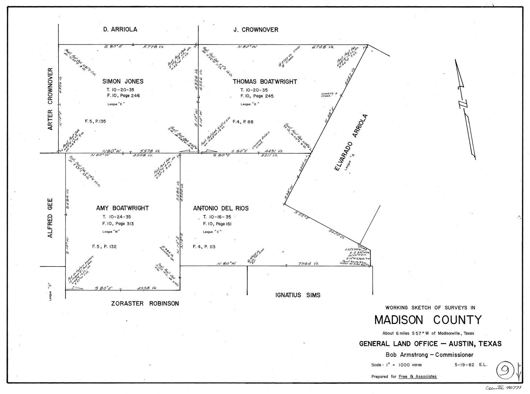
Madison County Working Sketch 9
-
Map/Doc
70771
-
Collection
General Map Collection
-
Object Dates
5/19/1982 (Creation Date)
-
People and Organizations
Elisandro Leos (Draftsman)
-
Counties
Madison
-
Subjects
Surveying Working Sketch
-
Height x Width
15.7 x 21.1 inches
39.9 x 53.6 cm
-
Scale
1" = 1000 varas
Part of: General Map Collection
Hemphill County Working Sketch 1

Print $20.00
- Digital $50.00
Hemphill County Working Sketch 1
1926
Size 15.1 x 19.7 inches
Map/Doc 66096
Burnet County Boundary File 12c

Print $8.00
- Digital $50.00
Burnet County Boundary File 12c
Size 12.8 x 8.3 inches
Map/Doc 50964
North Shore of West Bay and Galveston Island

Print $40.00
- Digital $50.00
North Shore of West Bay and Galveston Island
1933
Size 36.4 x 56.9 inches
Map/Doc 69931
Copy of Surveyor's Field Book, Morris Browning - In Blocks 7, 5 & 4, I&GNRRCo., Hutchinson and Carson Counties, Texas

Print $2.00
- Digital $50.00
Copy of Surveyor's Field Book, Morris Browning - In Blocks 7, 5 & 4, I&GNRRCo., Hutchinson and Carson Counties, Texas
1888
Size 6.8 x 8.8 inches
Map/Doc 62274
Lamar County Sketch File 8

Print $20.00
- Digital $50.00
Lamar County Sketch File 8
1895
Size 21.4 x 23.1 inches
Map/Doc 11966
Garza County Sketch File D

Print $20.00
- Digital $50.00
Garza County Sketch File D
1901
Size 18.4 x 12.2 inches
Map/Doc 11550
Sterling County

Print $20.00
- Digital $50.00
Sterling County
1891
Size 23.2 x 17.7 inches
Map/Doc 4056
Sabine County

Print $20.00
- Digital $50.00
Sabine County
1920
Size 43.5 x 34.2 inches
Map/Doc 63013
[Map] of Goliad Land District
![3586, [Map] of Goliad Land District, General Map Collection](https://historictexasmaps.com/wmedia_w700/maps/3586-1.tif.jpg)
Print $20.00
- Digital $50.00
[Map] of Goliad Land District
1856
Size 33.5 x 25.2 inches
Map/Doc 3586
Flight Mission No. BQY-4M, Frame 44, Harris County

Print $20.00
- Digital $50.00
Flight Mission No. BQY-4M, Frame 44, Harris County
1953
Size 18.5 x 22.4 inches
Map/Doc 85259
Presidio County Rolled Sketch 131B

Print $20.00
- Digital $50.00
Presidio County Rolled Sketch 131B
1993
Size 33.4 x 46.7 inches
Map/Doc 9803
Northeast Part Pecos County

Print $20.00
- Digital $50.00
Northeast Part Pecos County
1975
Size 36.9 x 43.4 inches
Map/Doc 95611
You may also like
Runnels County Sketch File 16

Print $20.00
Runnels County Sketch File 16
1879
Size 17.0 x 9.1 inches
Map/Doc 35470
Bell County Sketch File 26

Print $14.00
- Digital $50.00
Bell County Sketch File 26
1886
Size 14.2 x 8.8 inches
Map/Doc 14426
Culberson County Rolled Sketch 48

Print $335.00
- Digital $50.00
Culberson County Rolled Sketch 48
1960
Size 11.0 x 15.4 inches
Map/Doc 45339
Edwards County Boundary File 27e

Print $11.00
- Digital $50.00
Edwards County Boundary File 27e
Size 12.8 x 8.5 inches
Map/Doc 52906
Hill County Rolled Sketch 1

Print $20.00
- Digital $50.00
Hill County Rolled Sketch 1
1950
Size 13.1 x 41.0 inches
Map/Doc 6214
General Highway Map Llano County Texas

Print $20.00
- Digital $50.00
General Highway Map Llano County Texas
1953
Size 17.1 x 12.5 inches
Map/Doc 92883
West Part of Liberty Co.

Print $20.00
- Digital $50.00
West Part of Liberty Co.
1977
Size 46.2 x 35.5 inches
Map/Doc 73220
Shackelford County Rolled Sketch 2

Print $40.00
- Digital $50.00
Shackelford County Rolled Sketch 2
Size 18.9 x 51.9 inches
Map/Doc 75935
Presidio County Sketch File 81

Print $20.00
- Digital $50.00
Presidio County Sketch File 81
1949
Size 47.2 x 21.6 inches
Map/Doc 10579

Flight Mission No. DQO-8K, Frame 70, Galveston County

Print $20.00
- Digital $50.00
Flight Mission No. DQO-8K, Frame 70, Galveston County
1952
Size 18.7 x 22.3 inches
Map/Doc 85174
Flight Mission No. CGI-3N, Frame 186, Cameron County

Print $20.00
- Digital $50.00
Flight Mission No. CGI-3N, Frame 186, Cameron County
1954
Size 18.6 x 22.3 inches
Map/Doc 84650