Three Sitios of Land Granted to Vicente Micheli April 28th 1806

Print $2.00
- Digital $50.00
Three Sitios of Land Granted to Vicente Micheli April 28th 1806
1835
Size: 11.8 x 8.1 inches
170
Plan of Three Sitios of Land Granted to Vicente Micheli

Print $2.00
- Digital $50.00
Plan of Three Sitios of Land Granted to Vicente Micheli
Size: 9.2 x 8.6 inches
18
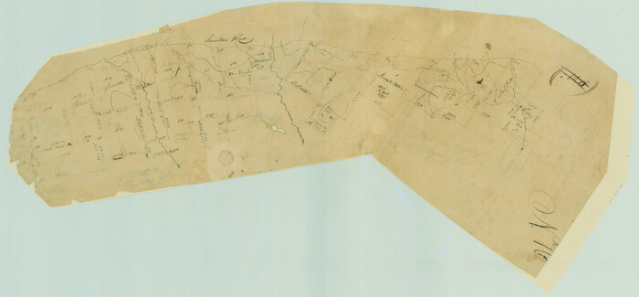
[Surveys in Austin's Colony along the San Antonio Road and the Navasota River]
Print $20.00
- Digital $50.00
[Surveys in Austin's Colony along the San Antonio Road and the Navasota River]
1833
Size: 16.1 x 34.7 inches
202
Map of Madison County

Print $20.00
- Digital $50.00
Map of Madison County
1880
Size: 17.0 x 24.9 inches
3832
Map of Madison County

Print $20.00
- Digital $50.00
Map of Madison County
1858
Size: 19.8 x 31.7 inches
3834
Map of Ferguson State Farm, Madison County, Texas

Print $20.00
- Digital $50.00
Map of Ferguson State Farm, Madison County, Texas
Size: 21.6 x 26.1 inches
62989
Ferguson State Farm

Print $20.00
- Digital $50.00
Ferguson State Farm
Size: 19.2 x 20.4 inches
62990
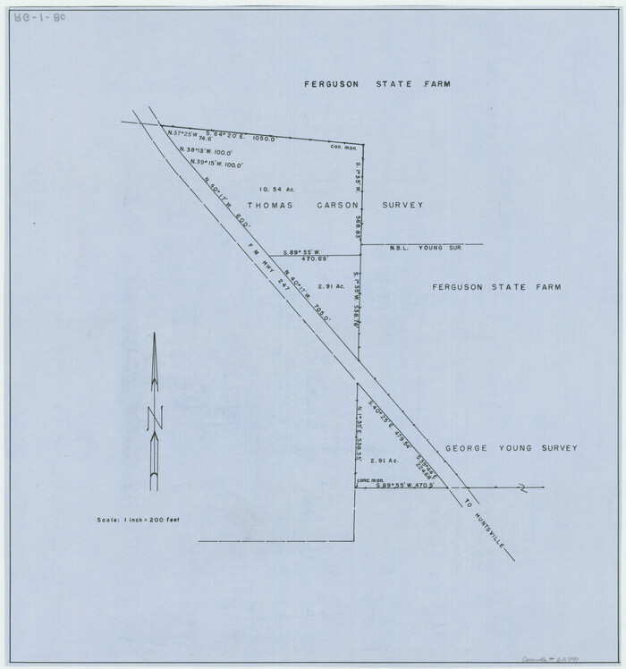
[Ferguson State Farm]
Print $20.00
- Digital $50.00
[Ferguson State Farm]
Size: 17.2 x 16.1 inches
62991
Grimes County Working Sketch 11

Print $20.00
- Digital $50.00
Grimes County Working Sketch 11
1981
Size: 22.7 x 22.6 inches
63302
Map of Madison County, Texas

Print $20.00
- Digital $50.00
Map of Madison County, Texas
1879
Size: 17.1 x 21.7 inches
643
San Jacinto River, Water Sheds of the San Jacinto River and Buffalo Bayou

Print $4.00
- Digital $50.00
San Jacinto River, Water Sheds of the San Jacinto River and Buffalo Bayou
Size: 28.8 x 20.0 inches
65149
Trinity River, Big Creek Sheet

Print $40.00
- Digital $50.00
Trinity River, Big Creek Sheet
1924
Size: 48.0 x 36.4 inches
65179
Trinity River, Clapps Ferry Sheet

Print $20.00
- Digital $50.00
Trinity River, Clapps Ferry Sheet
1925
Size: 47.5 x 36.4 inches
65180
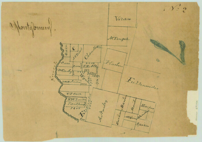
Sketches of Surveys in Montgomery Co.

Print $2.00
- Digital $50.00
Sketches of Surveys in Montgomery Co.
1845
Size: 10.2 x 8.0 inches
69731
[Surveys in the Montgomery District: San Jacinto River and Caney Creek, Navidad, Navasota]
Print $2.00
- Digital $50.00
[Surveys in the Montgomery District: San Jacinto River and Caney Creek, Navidad, Navasota]
Size: 5.1 x 7.3 inches
69744
Leon County Working Sketch 11

Print $20.00
- Digital $50.00
Leon County Working Sketch 11
1952
Size: 21.1 x 35.0 inches
70410
Madison County Working Sketch 1

Print $20.00
- Digital $50.00
Madison County Working Sketch 1
1913
Size: 42.4 x 36.9 inches
70763
Madison County Working Sketch 2

Print $20.00
- Digital $50.00
Madison County Working Sketch 2
1933
Size: 23.4 x 25.5 inches
70764
Madison County Working Sketch 3

Print $20.00
- Digital $50.00
Madison County Working Sketch 3
1945
Size: 29.3 x 21.6 inches
70765
Madison County Working Sketch 4

Print $20.00
- Digital $50.00
Madison County Working Sketch 4
1973
Size: 12.7 x 12.9 inches
70766
Madison County Working Sketch 5

Print $20.00
- Digital $50.00
Madison County Working Sketch 5
1981
Size: 24.0 x 24.1 inches
70767
Madison County Working Sketch 6

Print $2.00
- Digital $50.00
Madison County Working Sketch 6
1982
Size: 10.5 x 7.7 inches
70768
Madison County Working Sketch 7

Print $20.00
- Digital $50.00
Madison County Working Sketch 7
1982
Size: 12.7 x 17.4 inches
70769
Madison County Working Sketch 8

Print $20.00
- Digital $50.00
Madison County Working Sketch 8
1982
Size: 22.4 x 28.8 inches
70770
Madison County Working Sketch 9

Print $20.00
- Digital $50.00
Madison County Working Sketch 9
1982
Size: 15.7 x 21.1 inches
70771
Madison County Working Sketch 10

Print $20.00
- Digital $50.00
Madison County Working Sketch 10
1960
Size: 34.7 x 32.0 inches
70772
Madison County Working Sketch 11

Print $20.00
- Digital $50.00
Madison County Working Sketch 11
1964
Size: 39.6 x 33.4 inches
70773
Three Sitios of Land Granted to Vicente Micheli April 28th 1806
Print $2.00
- Digital $50.00
Three Sitios of Land Granted to Vicente Micheli April 28th 1806
1835
-
Size
11.8 x 8.1 inches
-
Map/Doc
170
-
Creation Date
1835
Plan of Three Sitios of Land Granted to Vicente Micheli
Print $2.00
- Digital $50.00
Plan of Three Sitios of Land Granted to Vicente Micheli
-
Size
9.2 x 8.6 inches
-
Map/Doc
18
Madison Co.

Print $40.00
- Digital $50.00
Madison Co.
1922
-
Size
30.9 x 48.5 inches
-
Map/Doc
1886
-
Creation Date
1922
[Surveys in Austin's Colony along the San Antonio Road and the Navasota River]
Print $20.00
- Digital $50.00
[Surveys in Austin's Colony along the San Antonio Road and the Navasota River]
1833
-
Size
16.1 x 34.7 inches
-
Map/Doc
202
-
Creation Date
1833
Map of Madison County
Print $20.00
- Digital $50.00
Map of Madison County
1880
-
Size
17.0 x 24.9 inches
-
Map/Doc
3832
-
Creation Date
1880
Madison County

Print $20.00
- Digital $50.00
Madison County
1871
-
Size
14.0 x 19.6 inches
-
Map/Doc
3833
-
Creation Date
1871
Map of Madison County
Print $20.00
- Digital $50.00
Map of Madison County
1858
-
Size
19.8 x 31.7 inches
-
Map/Doc
3834
-
Creation Date
1858
Madison County

Print $20.00
- Digital $50.00
Madison County
1871
-
Size
15.2 x 20.3 inches
-
Map/Doc
4587
-
Creation Date
1871
Map of Ferguson State Farm, Madison County, Texas
Print $20.00
- Digital $50.00
Map of Ferguson State Farm, Madison County, Texas
-
Size
21.6 x 26.1 inches
-
Map/Doc
62989
Ferguson State Farm
Print $20.00
- Digital $50.00
Ferguson State Farm
-
Size
19.2 x 20.4 inches
-
Map/Doc
62990
[Ferguson State Farm]
Print $20.00
- Digital $50.00
[Ferguson State Farm]
-
Size
17.2 x 16.1 inches
-
Map/Doc
62991
Grimes County Working Sketch 11
Print $20.00
- Digital $50.00
Grimes County Working Sketch 11
1981
-
Size
22.7 x 22.6 inches
-
Map/Doc
63302
-
Creation Date
1981
Map of Madison County, Texas
Print $20.00
- Digital $50.00
Map of Madison County, Texas
1879
-
Size
17.1 x 21.7 inches
-
Map/Doc
643
-
Creation Date
1879
San Jacinto River, Water Sheds of the San Jacinto River and Buffalo Bayou
Print $4.00
- Digital $50.00
San Jacinto River, Water Sheds of the San Jacinto River and Buffalo Bayou
-
Size
28.8 x 20.0 inches
-
Map/Doc
65149
Trinity River, Big Creek Sheet
Print $40.00
- Digital $50.00
Trinity River, Big Creek Sheet
1924
-
Size
48.0 x 36.4 inches
-
Map/Doc
65179
-
Creation Date
1924
Trinity River, Clapps Ferry Sheet
Print $20.00
- Digital $50.00
Trinity River, Clapps Ferry Sheet
1925
-
Size
47.5 x 36.4 inches
-
Map/Doc
65180
-
Creation Date
1925
Sketches of Surveys in Montgomery Co.
Print $2.00
- Digital $50.00
Sketches of Surveys in Montgomery Co.
1845
-
Size
10.2 x 8.0 inches
-
Map/Doc
69731
-
Creation Date
1845
[Surveys in the Montgomery District: San Jacinto River and Caney Creek, Navidad, Navasota]
Print $2.00
- Digital $50.00
[Surveys in the Montgomery District: San Jacinto River and Caney Creek, Navidad, Navasota]
-
Size
5.1 x 7.3 inches
-
Map/Doc
69744
Leon County Working Sketch 11
Print $20.00
- Digital $50.00
Leon County Working Sketch 11
1952
-
Size
21.1 x 35.0 inches
-
Map/Doc
70410
-
Creation Date
1952
Madison County Working Sketch 1
Print $20.00
- Digital $50.00
Madison County Working Sketch 1
1913
-
Size
42.4 x 36.9 inches
-
Map/Doc
70763
-
Creation Date
1913
Madison County Working Sketch 2
Print $20.00
- Digital $50.00
Madison County Working Sketch 2
1933
-
Size
23.4 x 25.5 inches
-
Map/Doc
70764
-
Creation Date
1933
Madison County Working Sketch 3
Print $20.00
- Digital $50.00
Madison County Working Sketch 3
1945
-
Size
29.3 x 21.6 inches
-
Map/Doc
70765
-
Creation Date
1945
Madison County Working Sketch 4
Print $20.00
- Digital $50.00
Madison County Working Sketch 4
1973
-
Size
12.7 x 12.9 inches
-
Map/Doc
70766
-
Creation Date
1973
Madison County Working Sketch 5
Print $20.00
- Digital $50.00
Madison County Working Sketch 5
1981
-
Size
24.0 x 24.1 inches
-
Map/Doc
70767
-
Creation Date
1981
Madison County Working Sketch 6
Print $2.00
- Digital $50.00
Madison County Working Sketch 6
1982
-
Size
10.5 x 7.7 inches
-
Map/Doc
70768
-
Creation Date
1982
Madison County Working Sketch 7
Print $20.00
- Digital $50.00
Madison County Working Sketch 7
1982
-
Size
12.7 x 17.4 inches
-
Map/Doc
70769
-
Creation Date
1982
Madison County Working Sketch 8
Print $20.00
- Digital $50.00
Madison County Working Sketch 8
1982
-
Size
22.4 x 28.8 inches
-
Map/Doc
70770
-
Creation Date
1982
Madison County Working Sketch 9
Print $20.00
- Digital $50.00
Madison County Working Sketch 9
1982
-
Size
15.7 x 21.1 inches
-
Map/Doc
70771
-
Creation Date
1982
Madison County Working Sketch 10
Print $20.00
- Digital $50.00
Madison County Working Sketch 10
1960
-
Size
34.7 x 32.0 inches
-
Map/Doc
70772
-
Creation Date
1960
Madison County Working Sketch 11
Print $20.00
- Digital $50.00
Madison County Working Sketch 11
1964
-
Size
39.6 x 33.4 inches
-
Map/Doc
70773
-
Creation Date
1964