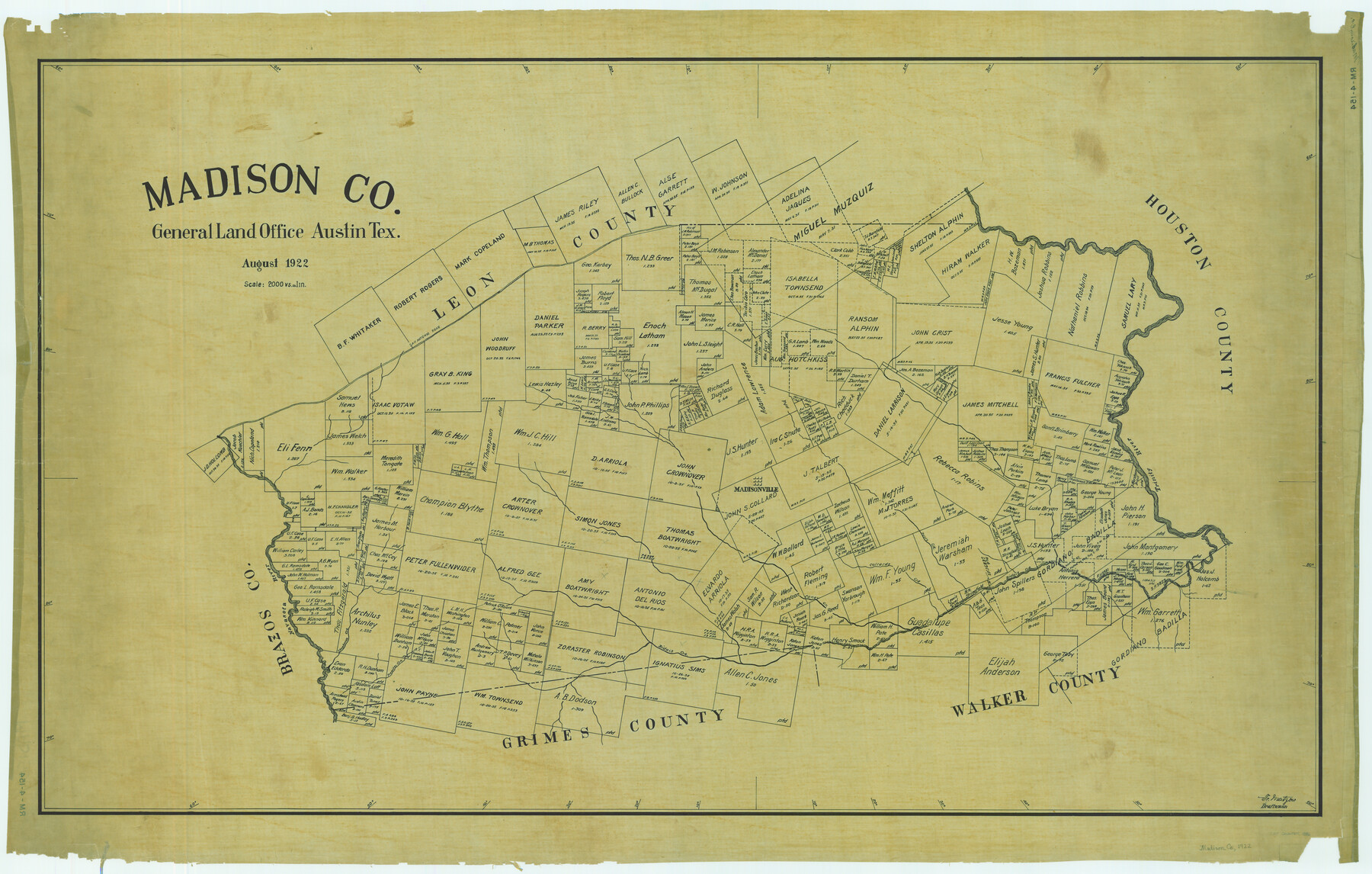
Madison Co.
RM-4-154
-
Map/Doc
1886
-
Collection
General Map Collection
-
Object Dates
1922 (Creation Date)
-
People and Organizations
Texas General Land Office (Publisher)
Fr. Matzow (Compiler)
Fr. Matzow (Draftsman)
-
Counties
Madison
-
Subjects
County
-
Height x Width
30.9 x 48.5 inches
78.5 x 123.2 cm
Part of: General Map Collection
Flight Mission No. CGI-3N, Frame 141, Cameron County

Print $20.00
- Digital $50.00
Flight Mission No. CGI-3N, Frame 141, Cameron County
1954
Size 18.6 x 22.3 inches
Map/Doc 84614
Uvalde County Sketch File 14

Print $6.00
- Digital $50.00
Uvalde County Sketch File 14
1849
Size 8.5 x 11.0 inches
Map/Doc 12529
Calhoun County Rolled Sketch 22

Print $20.00
- Digital $50.00
Calhoun County Rolled Sketch 22
Size 35.0 x 37.0 inches
Map/Doc 8552
Burleson County Working Sketch 46

Print $20.00
- Digital $50.00
Burleson County Working Sketch 46
1995
Size 30.6 x 36.9 inches
Map/Doc 67765

West Part Houston Co.

Print $20.00
- Digital $50.00
West Part Houston Co.
1944
Size 47.2 x 41.6 inches
Map/Doc 77317
Flight Mission No. CUG-3P, Frame 37, Kleberg County

Print $20.00
- Digital $50.00
Flight Mission No. CUG-3P, Frame 37, Kleberg County
1956
Size 18.5 x 22.2 inches
Map/Doc 86242

Mason County Working Sketch 11

Print $20.00
- Digital $50.00
Mason County Working Sketch 11
1951
Size 24.7 x 23.7 inches
Map/Doc 70847

Bowie County Sketch File 1

Print $8.00
- Digital $50.00
Bowie County Sketch File 1
Size 8.6 x 10.0 inches
Map/Doc 14833
[Map Showing Parmer, Castro, Bailey, Lamb, Cochran & Hockley Counties, Texas]
![1762, [Map Showing Parmer, Castro, Bailey, Lamb, Cochran & Hockley Counties, Texas], General Map Collection](https://historictexasmaps.com/wmedia_w700/maps/1762.tif.jpg)
Print $40.00
- Digital $50.00
[Map Showing Parmer, Castro, Bailey, Lamb, Cochran & Hockley Counties, Texas]
1910
Size 55.3 x 40.1 inches
Map/Doc 1762
You may also like


Paris, Texas, County Seat of Lamar County

Print $20.00
Paris, Texas, County Seat of Lamar County
1885
Size 17.8 x 23.8 inches
Map/Doc 89201
Trinity River, Carl Switch Sheet/Chambers Creek

Print $4.00
- Digital $50.00
Trinity River, Carl Switch Sheet/Chambers Creek
1926
Size 27.9 x 27.0 inches
Map/Doc 65217
El Paso County Rolled Sketch 33

Print $42.00
- Digital $50.00
El Paso County Rolled Sketch 33
Size 35.1 x 25.6 inches
Map/Doc 8867
Map showing lands surveyed by Sylvan Sanders in the Southwestern Part of Jack County, Texas for Buttram Petroleum Corporation

Print $20.00
- Digital $50.00
Map showing lands surveyed by Sylvan Sanders in the Southwestern Part of Jack County, Texas for Buttram Petroleum Corporation
Size 21.2 x 12.9 inches
Map/Doc 92186
Johnson County Working Sketch 2

Print $20.00
- Digital $50.00
Johnson County Working Sketch 2
Size 20.8 x 20.2 inches
Map/Doc 66615
Young County Working Sketch 7

Print $20.00
- Digital $50.00
Young County Working Sketch 7
1919
Size 24.3 x 19.8 inches
Map/Doc 62030
West Part Presidio Co.

Print $20.00
- Digital $50.00
West Part Presidio Co.
1974
Size 40.5 x 31.4 inches
Map/Doc 77399
Morris County Rolled Sketch 2A

Print $20.00
- Digital $50.00
Morris County Rolled Sketch 2A
Size 24.0 x 18.7 inches
Map/Doc 10225
Flight Mission No. DIX-10P, Frame 81, Aransas County

Print $20.00
- Digital $50.00
Flight Mission No. DIX-10P, Frame 81, Aransas County
1956
Size 18.7 x 22.4 inches
Map/Doc 83942
Kimble County Rolled Sketch 40

Print $20.00
- Digital $50.00
Kimble County Rolled Sketch 40
Size 27.5 x 22.4 inches
Map/Doc 6530