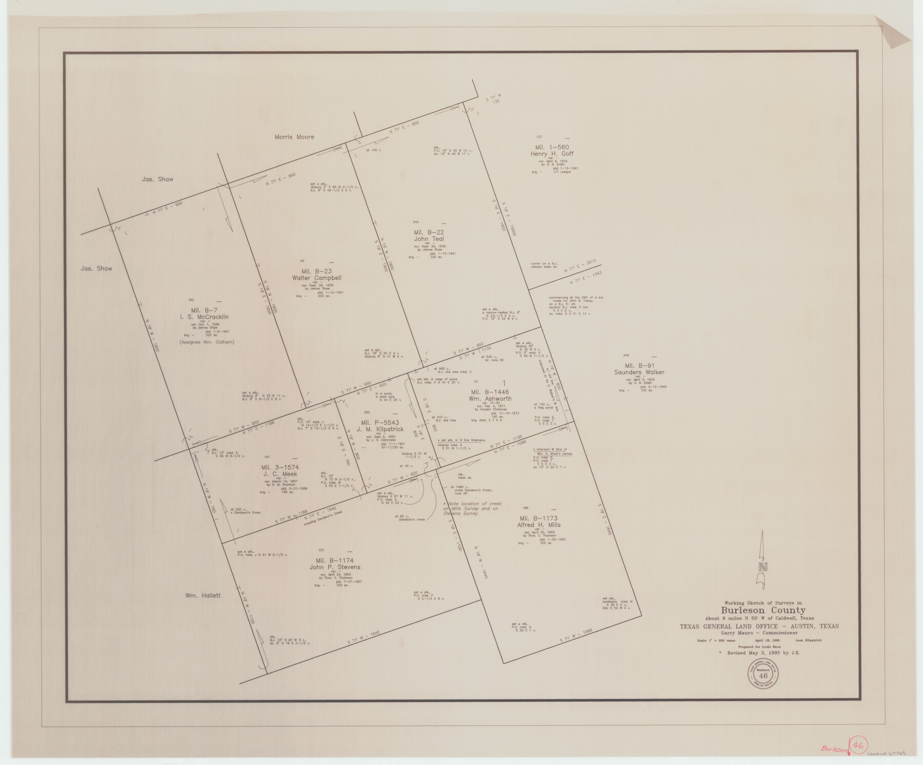
Burleson County Working Sketch 46
-
Map/Doc
67765
-
Collection
General Map Collection
-
Counties
Burleson
-
Subjects
Cadastral Surveying Working Sketch
-
Height x Width
30.6 x 36.9 inches
77.7 x 93.7 cm
Part of: General Map Collection
Flight Mission No. DQO-6K, Frame 34, Galveston County
![85100, Flight Mission No. DQO-6K, Frame 34, Galveston County, General Map Collection](https://historictexasmaps.com/wmedia_w700/pdf_converted_jpg/qi_pdf_thumbnail_32309.jpg)
Print $20.00
- Digital $50.00
Flight Mission No. DQO-6K, Frame 34, Galveston County
1952
Size 18.7 x 22.4 inches
Map/Doc 85100
Flight Mission No. BRE-1P, Frame 32, Nueces County
![86628, Flight Mission No. BRE-1P, Frame 32, Nueces County, General Map Collection](https://historictexasmaps.com/wmedia_w700/pdf_converted_jpg/qi_pdf_thumbnail_33768.jpg)
Print $20.00
- Digital $50.00
Flight Mission No. BRE-1P, Frame 32, Nueces County
1956
Size 18.4 x 22.6 inches
Map/Doc 86628
No. 2 Chart of Corpus Christi Pass, Texas
![73025, No. 2 Chart of Corpus Christi Pass, Texas, General Map Collection](https://historictexasmaps.com/wmedia_w700/maps/73025.tif.jpg)
Print $20.00
- Digital $50.00
No. 2 Chart of Corpus Christi Pass, Texas
1878
Size 18.2 x 27.1 inches
Map/Doc 73025
Gaines County Working Sketch 22
![69322, Gaines County Working Sketch 22, General Map Collection](https://historictexasmaps.com/wmedia_w700/maps/69322.tif.jpg)
Print $40.00
- Digital $50.00
Gaines County Working Sketch 22
Size 52.5 x 33.9 inches
Map/Doc 69322
Flight Mission No. DAG-23K, Frame 15, Matagorda County
![86477, Flight Mission No. DAG-23K, Frame 15, Matagorda County, General Map Collection](https://historictexasmaps.com/wmedia_w700/pdf_converted_jpg/qi_pdf_thumbnail_33621.jpg)
Print $20.00
- Digital $50.00
Flight Mission No. DAG-23K, Frame 15, Matagorda County
1953
Size 15.5 x 15.3 inches
Map/Doc 86477
Bee County Sketch File 3
![14261, Bee County Sketch File 3, General Map Collection](https://historictexasmaps.com/wmedia_w700/pdf_converted_jpg/qi_pdf_thumbnail_9314.jpg)
Print $6.00
- Digital $50.00
Bee County Sketch File 3
1846
Size 12.5 x 7.6 inches
Map/Doc 14261
Midland County
![73239, Midland County, General Map Collection](https://historictexasmaps.com/wmedia_w700/maps/73239.tif.jpg)
Print $20.00
- Digital $50.00
Midland County
1930
Size 44.9 x 38.5 inches
Map/Doc 73239
Val Verde County Sketch File 46
![12587, Val Verde County Sketch File 46, General Map Collection](https://historictexasmaps.com/wmedia_w700/pdf_converted_jpg/qi_pdf_thumbnail_8860.jpg)
Print $20.00
- Digital $50.00
Val Verde County Sketch File 46
1951
Size 18.9 x 22.6 inches
Map/Doc 12587
Kimble County Working Sketch 5
![70073, Kimble County Working Sketch 5, General Map Collection](https://historictexasmaps.com/wmedia_w700/maps/70073.tif.jpg)
Print $20.00
- Digital $50.00
Kimble County Working Sketch 5
Size 17.0 x 13.4 inches
Map/Doc 70073
Dimmit County Rolled Sketch 5
![5715, Dimmit County Rolled Sketch 5, General Map Collection](https://historictexasmaps.com/wmedia_w700/maps/5715.tif.jpg)
Print $20.00
- Digital $50.00
Dimmit County Rolled Sketch 5
1904
Size 42.7 x 18.2 inches
Map/Doc 5715
Randall County Sketch File 11
![34974, Randall County Sketch File 11, General Map Collection](https://historictexasmaps.com/wmedia_w700/pdf_converted_jpg/qi_pdf_thumbnail_13800.jpg)
Print $4.00
- Digital $50.00
Randall County Sketch File 11
1944
Size 3.4 x 5.7 inches
Map/Doc 34974
Throckmorton County Working Sketch 7
![62116, Throckmorton County Working Sketch 7, General Map Collection](https://historictexasmaps.com/wmedia_w700/maps/62116.tif.jpg)
Print $20.00
- Digital $50.00
Throckmorton County Working Sketch 7
Size 25.8 x 32.0 inches
Map/Doc 62116
You may also like
McLennan County Sketch File 7b
![31248, McLennan County Sketch File 7b, General Map Collection](https://historictexasmaps.com/wmedia_w700/pdf_converted_jpg/qi_pdf_thumbnail_12973.jpg)
Print $6.00
- Digital $50.00
McLennan County Sketch File 7b
1857
Size 8.0 x 10.1 inches
Map/Doc 31248
Lamar County Working Sketch 3
![70264, Lamar County Working Sketch 3, General Map Collection](https://historictexasmaps.com/wmedia_w700/maps/70264.tif.jpg)
Print $20.00
- Digital $50.00
Lamar County Working Sketch 3
Size 26.2 x 24.5 inches
Map/Doc 70264
Runnels County Working Sketch 18
![63614, Runnels County Working Sketch 18, General Map Collection](https://historictexasmaps.com/wmedia_w700/maps/63614.tif.jpg)
Print $20.00
- Digital $50.00
Runnels County Working Sketch 18
Size 27.9 x 31.2 inches
Map/Doc 63614
Borden County Working Sketch 7
![67467, Borden County Working Sketch 7, General Map Collection](https://historictexasmaps.com/wmedia_w700/maps/67467.tif.jpg)
Print $20.00
- Digital $50.00
Borden County Working Sketch 7
1947
Size 21.0 x 22.5 inches
Map/Doc 67467
Flight Mission No. CLL-1N, Frame 86, Willacy County
![87032, Flight Mission No. CLL-1N, Frame 86, Willacy County, General Map Collection](https://historictexasmaps.com/wmedia_w700/pdf_converted_jpg/qi_pdf_thumbnail_34166.jpg)
Print $20.00
- Digital $50.00
Flight Mission No. CLL-1N, Frame 86, Willacy County
1954
Size 18.4 x 22.1 inches
Map/Doc 87032
[Aaron Cherry and A. M. de Lejarza Surveys on the Trinity River]
![91080, [Aaron Cherry and A. M. de Lejarza Surveys on the Trinity River], Twichell Survey Records](https://historictexasmaps.com/wmedia_w700/maps/91080-1.tif.jpg)
Print $20.00
- Digital $50.00
[Aaron Cherry and A. M. de Lejarza Surveys on the Trinity River]
Size 26.3 x 14.1 inches
Map/Doc 91080
Flight Mission No. DQO-8K, Frame 80, Galveston County
![85184, Flight Mission No. DQO-8K, Frame 80, Galveston County, General Map Collection](https://historictexasmaps.com/wmedia_w700/pdf_converted_jpg/qi_pdf_thumbnail_32392.jpg)
Print $20.00
- Digital $50.00
Flight Mission No. DQO-8K, Frame 80, Galveston County
1952
Size 18.8 x 22.5 inches
Map/Doc 85184
Flight Mission No. BQR-3K, Frame 153, Brazoria County
![83980, Flight Mission No. BQR-3K, Frame 153, Brazoria County, General Map Collection](https://historictexasmaps.com/wmedia_w700/pdf_converted_jpg/qi_pdf_thumbnail_31199.jpg)
Print $20.00
- Digital $50.00
Flight Mission No. BQR-3K, Frame 153, Brazoria County
1952
Size 18.7 x 22.4 inches
Map/Doc 83980
Angelina County Sketch File 2
![12921, Angelina County Sketch File 2, General Map Collection](https://historictexasmaps.com/wmedia_w700/pdf_converted_jpg/qi_pdf_thumbnail_9039.jpg)
Print $2.00
- Digital $50.00
Angelina County Sketch File 2
Size 8.6 x 6.0 inches
Map/Doc 12921
El Paso County Rolled Sketch 54
![44539, El Paso County Rolled Sketch 54](https://historictexasmaps.com/wmedia_w700/maps/44539.tif.jpg)
Print $20.00
- Digital $50.00
El Paso County Rolled Sketch 54
1980
Size 30.4 x 42.8 inches
Map/Doc 44539
Matagorda County Sketch File 17
![12040, Matagorda County Sketch File 17, General Map Collection](https://historictexasmaps.com/wmedia_w700/pdf_converted_jpg/qi_pdf_thumbnail_8394.jpg)
Print $20.00
- Digital $50.00
Matagorda County Sketch File 17
1877
Size 16.4 x 14.5 inches
Map/Doc 12040
Kinney County Sketch File 5
![29123, Kinney County Sketch File 5, General Map Collection](https://historictexasmaps.com/wmedia_w700/pdf_converted_jpg/qi_pdf_thumbnail_12485.jpg)
Print $2.00
- Digital $50.00
Kinney County Sketch File 5
Size 5.7 x 13.1 inches
Map/Doc 29123