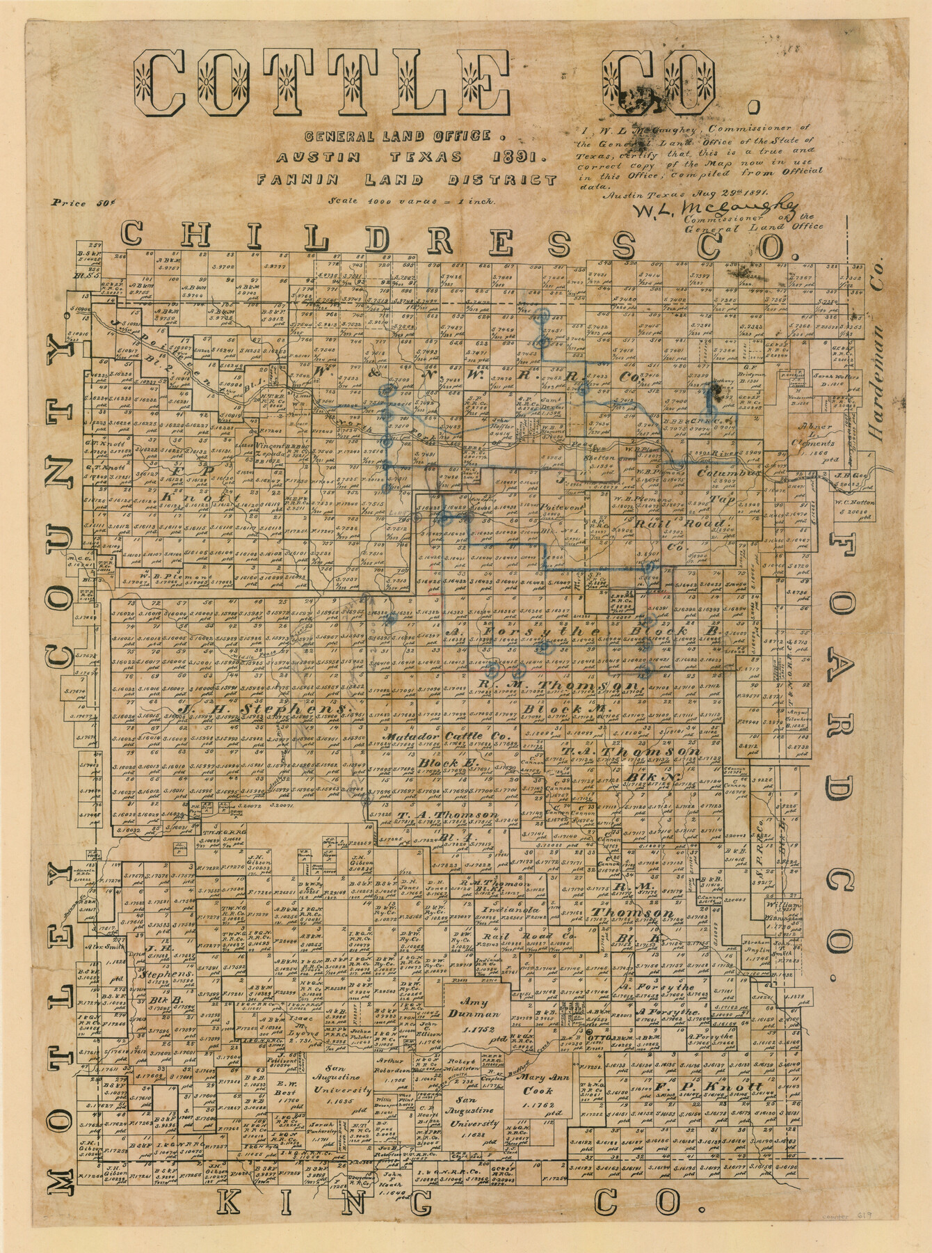
Cottle County, Texas
-
Map/Doc
619
-
Collection
Maddox Collection
-
Object Dates
8/29/1891 (Creation Date)
-
People and Organizations
General Land Office (Publisher)
W.L. McGaughey (GLO Commissioner)
-
Counties
Cottle
-
Subjects
County
-
Height x Width
23.1 x 17.0 inches
58.7 x 43.2 cm
-
Medium
paper, etching/engraving/lithograph
-
Scale
1" = 4000 varas
-
Comments
Conservation funded in 2011.
-
Features
North Fork of the Pease River
Middle Pease River
South Pease River
Autumn Creek
North Wichita or Bufford Creek
North Wichita Creek
Bufford Creek
Otto
Part of: Maddox Collection
[Sketch showing voting precincts in Jim Hogg and Brooks Counties]
![4497, [Sketch showing voting precincts in Jim Hogg and Brooks Counties], Maddox Collection](https://historictexasmaps.com/wmedia_w700/maps/4497-1.tif.jpg)
Print $20.00
- Digital $50.00
[Sketch showing voting precincts in Jim Hogg and Brooks Counties]
Size 10.1 x 18.2 inches
Map/Doc 4497
Survey in South Austin for Mr. R.N. Graham

Print $20.00
- Digital $50.00
Survey in South Austin for Mr. R.N. Graham
1915
Size 22.6 x 33.8 inches
Map/Doc 564
Map of Menard County, Texas

Print $20.00
- Digital $50.00
Map of Menard County, Texas
1879
Size 18.5 x 24.8 inches
Map/Doc 580
Sketch in Hardeman Co.

Print $20.00
- Digital $50.00
Sketch in Hardeman Co.
1890
Size 17.8 x 17.6 inches
Map/Doc 558
Map of SW portion of Hale Co., Texas

Print $3.00
- Digital $50.00
Map of SW portion of Hale Co., Texas
Size 12.7 x 10.8 inches
Map/Doc 518
Hansford County, Texas

Print $20.00
- Digital $50.00
Hansford County, Texas
1880
Size 19.9 x 18.9 inches
Map/Doc 528
[Sketch of Surveys in Cottle, Dickens, King & Motley Counties, Texas]
![75830, [Sketch of Surveys in Cottle, Dickens, King & Motley Counties, Texas], Maddox Collection](https://historictexasmaps.com/wmedia_w700/maps/75830.tif.jpg)
Print $20.00
- Digital $50.00
[Sketch of Surveys in Cottle, Dickens, King & Motley Counties, Texas]
1913
Size 29.6 x 23.2 inches
Map/Doc 75830

Sketch of Block B, GH & H RR & Blk C, CT RR Co, with surrounding & conflicting surveys in Knox & Baylor Counties

Print $20.00
- Digital $50.00
Sketch of Block B, GH & H RR & Blk C, CT RR Co, with surrounding & conflicting surveys in Knox & Baylor Counties
Size 24.9 x 17.9 inches
Map/Doc 75784
[Surveying Sketch of Houston and Texas Central R. R. Co., Gunter & Munson, Houston & Great Northern R. R. Co., International & Great Northern R. R. Company, et al]
![75763, [Surveying Sketch of Houston and Texas Central R. R. Co., Gunter & Munson, Houston & Great Northern R. R. Co., International & Great Northern R. R. Company, et al], Maddox Collection](https://historictexasmaps.com/wmedia_w700/maps/75763.tif.jpg)
Print $20.00
- Digital $50.00
[Surveying Sketch of Houston and Texas Central R. R. Co., Gunter & Munson, Houston & Great Northern R. R. Co., International & Great Northern R. R. Company, et al]
Size 23.1 x 28.3 inches
Map/Doc 75763
[Map of Townsite of Swearingen, Cottle County, Texas]
![4465, [Map of Townsite of Swearingen, Cottle County, Texas], Maddox Collection](https://historictexasmaps.com/wmedia_w700/maps/4465.tif.jpg)
Print $20.00
- Digital $50.00
[Map of Townsite of Swearingen, Cottle County, Texas]
Size 28.8 x 17.8 inches
Map/Doc 4465
Map of Comal County, Texas

Print $20.00
- Digital $50.00
Map of Comal County, Texas
1879
Size 23.4 x 28.6 inches
Map/Doc 701
You may also like
Austin's colony 1821-1836: In commemoration of the two hundredth birthday of Stephen F. Austin

Print $20.00
- Digital $50.00
Austin's colony 1821-1836: In commemoration of the two hundredth birthday of Stephen F. Austin
1993
Size 24.6 x 34.5 inches
Map/Doc 1675
Calhoun County Rolled Sketch 22

Print $20.00
- Digital $50.00
Calhoun County Rolled Sketch 22
Size 35.0 x 37.0 inches
Map/Doc 8552
Flight Mission No. BQY-4M, Frame 30, Harris County

Print $20.00
- Digital $50.00
Flight Mission No. BQY-4M, Frame 30, Harris County
1953
Size 18.7 x 22.4 inches
Map/Doc 85245
Refugio County NRC Article 33.136 Sketch 1

Print $44.00
- Digital $50.00
Refugio County NRC Article 33.136 Sketch 1
2002
Size 24.5 x 36.8 inches
Map/Doc 76399
Crane County Sketch File 24

Print $20.00
- Digital $50.00
Crane County Sketch File 24
Size 23.0 x 17.0 inches
Map/Doc 11212
Flight Mission No. DIX-3P, Frame 165, Aransas County

Print $20.00
- Digital $50.00
Flight Mission No. DIX-3P, Frame 165, Aransas County
1956
Size 17.8 x 18.4 inches
Map/Doc 83771
Travis County Working Sketch 56

Print $20.00
- Digital $50.00
Travis County Working Sketch 56
1989
Size 19.7 x 20.4 inches
Map/Doc 69440

[T. C. RR. Co. Blocks 178, A1, G. C. & S. F. R. R. Co. Block C4, E. L. & R. R. RR C3]
![93214, [T. C. RR. Co. Blocks 178, A1, G. C. & S. F. R. R. Co. Block C4, E. L. & R. R. RR C3], Twichell Survey Records](https://historictexasmaps.com/wmedia_w700/maps/93214-1.tif.jpg)
Print $20.00
- Digital $50.00
[T. C. RR. Co. Blocks 178, A1, G. C. & S. F. R. R. Co. Block C4, E. L. & R. R. RR C3]
Size 40.1 x 28.7 inches
Map/Doc 93214
Gillespie County Working Sketch 14

Print $20.00
- Digital $50.00
Gillespie County Working Sketch 14
2011
Size 36.6 x 36.6 inches
Map/Doc 90096
Roberts County Working Sketch 42

Print $20.00
- Digital $50.00
Roberts County Working Sketch 42
1978
Size 26.7 x 22.7 inches
Map/Doc 63568
Gillespie County Rolled Sketch 2

Print $20.00
- Digital $50.00
Gillespie County Rolled Sketch 2
1977
Size 22.8 x 22.7 inches
Map/Doc 6009