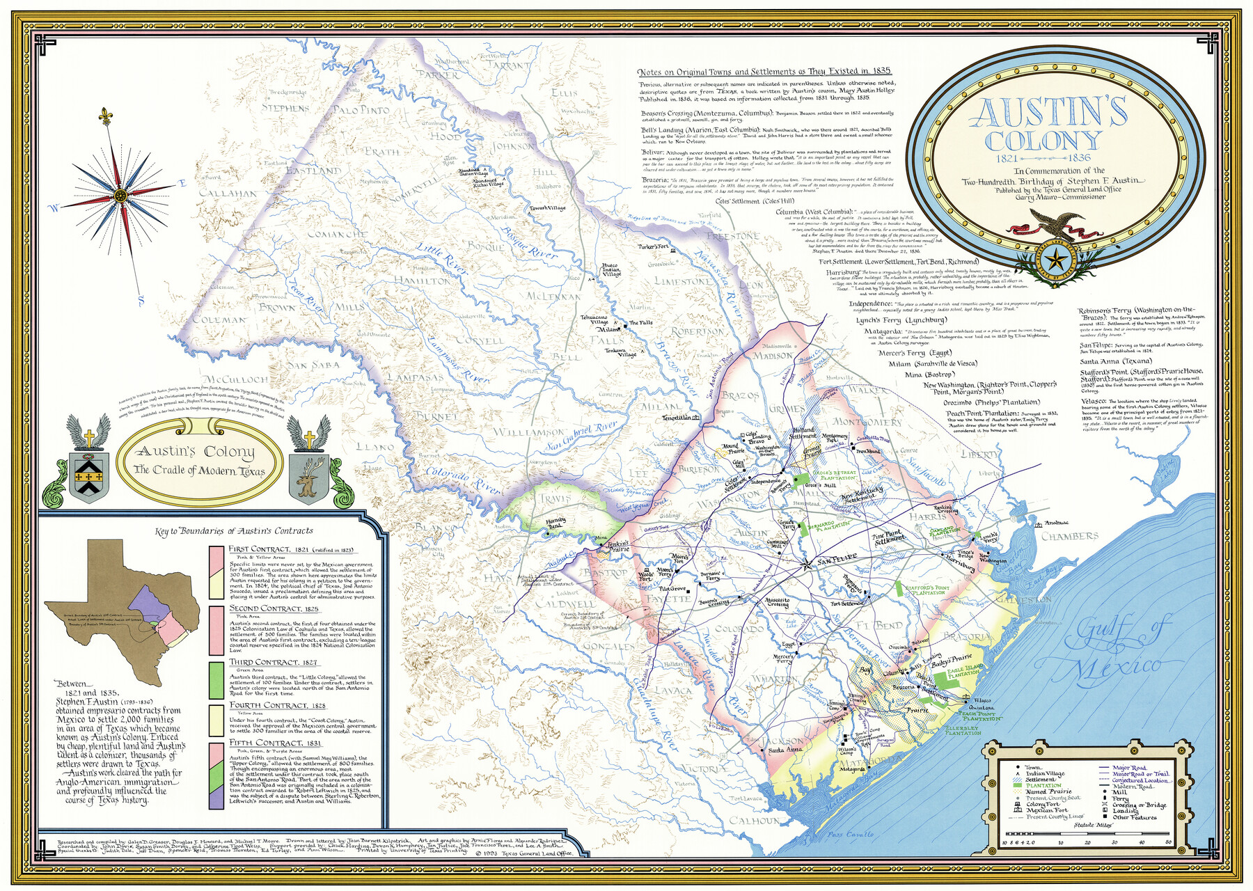
Austin's colony 1821-1836: In commemoration of the two hundredth birthday of Stephen F. Austin
-
Map/Doc
1675
-
Collection
General Map Collection
-
Object Dates
1993 (Creation Date)
-
People and Organizations
Texas General Land Office (Publisher)
University of Texas (Printer)
Galen Greaser (Compiler)
Michael T. Moore (Compiler)
Douglas Howard (Compiler)
Joan Kilpatrick (Draftsman)
-
Subjects
Colony
-
Height x Width
24.6 x 34.5 inches
62.5 x 87.6 cm
-
Medium
paper, etching/engraving/lithograph
-
Comments
Art and graphics by Arnie Flores and Alexander Rodriguez.
Current 1983 county lines, county seats and major roads overlaid on historical data. -
Features
San Felipe
Pine Point Settlement
Thompson's Ferry
Fort Settlement
Rankin's Crossing
Oakland Plantation
Lynch's Ferry
New Washington
Vince's Bridge
Harrisburg
Stafford's Point Plantation
Bolivar
Orozimbo
Columbia
Bell's Landing
Bailey's Prairie
Eagle Island Plantation
Peach Point Settlement
Velasco
Quintana
Bay Prairie
Peach Point Plantation
Ellersley Plantation
Egypt
Mercer's Ferry
Santa Anna
Jenning's Crossing
Jenning's Camp
Karankawa's Ford
Rawls' Camp
Wilson's Camp
Matagorda
Anahuac
Austin's Colony
San Antonio Road
La Bahia Road
Contraband Trace
Grimes' Road
Coushatta Trace
Gotier's Trace
Wilbarger Road
Pettus' Road
Madalena Road
Gonzales Road
Atascosito Road
Washington Road
Newman's Trace
New Road to Brazoria
Bay Road
Surveyor's Road
Navasota River
Bosque River
Little River
Pecan River
Lampasas River
San Gabriel River
Colorado River
Guadalupe River
Lavaca River
Navidad River
San Bernard River
Brazos River
San Jacinto River
Walnut Creek
Buckner's Creek
Wilson's Creek
Arroyo Trespalacios
Cummin's Creek
Caney Creek
Lone Tree Creek
West Bernard Creek
Linville's Bayou
Cedar Lake Creek
Eagle Lake
Eagle's Nest Lake
West Mill Creek
East Mill Creek
New Year Creek
Yegua Creek
Davidson's Creek
Hickory Creek
Hog Creek
Saline Creek
Oyster Bayou
Chocolate Bayou
Dickinson Bayou
Buffalo Bayou
Bidais Creek
Lake Creek
Mound Creek
Spring Creek
Cedar Bayou
Gulf of Mexico
Galveston Bay
East Bay
Matagorda Bay
Lavaca Bay
Pass Cavallo
Sabine Lake
Towash Village
Hueco Indian Village
Tehuacano Village
Tonkawa Village
Milam
Parker's Fort
Tenoxtitlan
Coles' Landing
Bravo
Washington-on-the-Brazos
Coles' Mill
Coles' Settlement
Independence
Mound Prairie
Grimes' Prairie
Holland Settlement
Montgomery Post
New Kentucky Settlement
Groce's Mill
Groce's Retreat Plantation
Robinson's Ferry
Groce's Ferry
Cummings' Mill
Hornsby Bend
Mina
Jenkin's Prairie
Woods' Fort
Moore's Ferry
Moore's Fort
Pilot Grove
Beason's Crossing
Burnam's Ferry
Atascosito Crossing
Part of: General Map Collection
Current Miscellaneous File 83

Print $2.00
- Digital $50.00
Current Miscellaneous File 83
1936
Size 8.3 x 10.6 inches
Map/Doc 74226
Anderson County Sketch File 18

Print $40.00
- Digital $50.00
Anderson County Sketch File 18
1880
Size 16.0 x 13.5 inches
Map/Doc 10801
Bexar County Sketch File 60

Print $4.00
- Digital $50.00
Bexar County Sketch File 60
2009
Size 11.0 x 8.5 inches
Map/Doc 93669
Brazos Santiago, Texas

Print $20.00
- Digital $50.00
Brazos Santiago, Texas
1900
Size 18.3 x 26.7 inches
Map/Doc 73032
Falls County Sketch File 20

Print $12.00
- Digital $50.00
Falls County Sketch File 20
1869
Size 10.0 x 8.3 inches
Map/Doc 22388
Hays County Sketch File 11

Print $4.00
- Digital $50.00
Hays County Sketch File 11
Size 10.3 x 8.2 inches
Map/Doc 26216
Knox County Rolled Sketch 26

Print $20.00
- Digital $50.00
Knox County Rolled Sketch 26
2007
Size 36.8 x 24.7 inches
Map/Doc 88822
Map of Colorado County

Print $20.00
- Digital $50.00
Map of Colorado County
1881
Size 22.5 x 21.4 inches
Map/Doc 3427
Flight Mission No. DCL-6C, Frame 123, Kenedy County

Print $20.00
- Digital $50.00
Flight Mission No. DCL-6C, Frame 123, Kenedy County
1943
Size 18.6 x 22.3 inches
Map/Doc 85953
Tyler County Sketch File 3

Print $10.00
- Digital $50.00
Tyler County Sketch File 3
1855
Size 8.5 x 8.0 inches
Map/Doc 38622
Rusk County Working Sketch 1

Print $20.00
- Digital $50.00
Rusk County Working Sketch 1
Size 14.2 x 23.1 inches
Map/Doc 63636
Coast Chart No. 209 - Aransas Pass, Aransas and Copano Bays, Texas

Print $20.00
- Digital $50.00
Coast Chart No. 209 - Aransas Pass, Aransas and Copano Bays, Texas
1889
Size 31.2 x 24.9 inches
Map/Doc 73429
You may also like
Llano County Working Sketch 5

Print $20.00
- Digital $50.00
Llano County Working Sketch 5
1961
Size 43.1 x 34.4 inches
Map/Doc 70623


Galveston County Sketch File 70

Print $26.00
- Digital $50.00
Galveston County Sketch File 70
1983
Size 11.3 x 8.7 inches
Map/Doc 23928
Hudspeth County Working Sketch Graphic Index

Print $40.00
- Digital $50.00
Hudspeth County Working Sketch Graphic Index
1943
Size 53.7 x 39.3 inches
Map/Doc 76584
Lampasas County Boundary File 17

Print $27.00
- Digital $50.00
Lampasas County Boundary File 17
Size 7.2 x 8.8 inches
Map/Doc 56236

Austin County

Print $20.00
- Digital $50.00
Austin County
1943
Size 40.2 x 43.0 inches
Map/Doc 95422
Hardin County Working Sketch 8

Print $20.00
- Digital $50.00
Hardin County Working Sketch 8
1926
Size 16.5 x 21.0 inches
Map/Doc 63406
Kendall County Working Sketch 10

Print $20.00
- Digital $50.00
Kendall County Working Sketch 10
1954
Size 21.2 x 24.9 inches
Map/Doc 66682
San Patricio County Sketch File 31

Print $6.00
- Digital $50.00
San Patricio County Sketch File 31
Size 14.0 x 10.0 inches
Map/Doc 36117
Flight Mission No. CRK-8P, Frame 118, Refugio County

Print $20.00
- Digital $50.00
Flight Mission No. CRK-8P, Frame 118, Refugio County
1956
Size 18.3 x 22.1 inches
Map/Doc 86973