![75830, [Sketch of Surveys in Cottle, Dickens, King & Motley Counties, Texas], Maddox Collection](https://historictexasmaps.com/wmedia_w1800h1800/maps/75830.tif.jpg)
[Sketch of Surveys in Cottle, Dickens, King & Motley Counties, Texas]
-
Map/Doc
75830
-
Collection
Maddox Collection
-
Object Dates
1913 (Creation Date)
-
People and Organizations
Geo. M. Williams (Surveyor/Engineer)
-
Counties
Cottle King Dickens Motley
-
Height x Width
29.6 x 23.2 inches
75.2 x 58.9 cm
-
Medium
blueprint/diazo
-
Comments
Note written on the back: William's Map of Surveys North of Buffalo King County, Texas, D. B. Gardner, 4 Ranch work.
-
Features
QA&P
Bluff Creek
Tongue River
Horse Canon
Willow Branch Canon
Middle Creek
West Creek
North Wichita
Water Canon
Camp Hollow
Gibson Bluff Creek
Narcisso
China [Creek]
Thief Creek
Dumont
Part of: Maddox Collection
Map showing the John B. Pier Survey, Near Houston

Print $3.00
- Digital $50.00
Map showing the John B. Pier Survey, Near Houston
Size 11.9 x 17.8 inches
Map/Doc 478
[Sketch of Surveys in Crockett County, Texas]
![10778, [Sketch of Surveys in Crockett County, Texas], Maddox Collection](https://historictexasmaps.com/wmedia_w700/maps/10778-1.tif.jpg)
Print $20.00
- Digital $50.00
[Sketch of Surveys in Crockett County, Texas]
1880
Size 12.7 x 21.3 inches
Map/Doc 10778
Map of Navarro County, Texas

Print $20.00
- Digital $50.00
Map of Navarro County, Texas
1871
Size 23.5 x 28.7 inches
Map/Doc 662
Map of Cherokee County, Texas

Print $20.00
- Digital $50.00
Map of Cherokee County, Texas
1879
Size 30.8 x 24.0 inches
Map/Doc 696
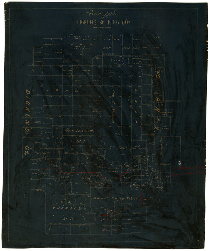
Working Sketch in Dickens & King Cos.
Print $20.00
- Digital $50.00
Working Sketch in Dickens & King Cos.
Size 24.4 x 20.4 inches
Map/Doc 10770
[Surveying sketch of Dan'l. Dunham, O. de Santangelo, et al in Zavala County]
![708, [Surveying sketch of Dan'l. Dunham, O. de Santangelo, et al in Zavala County], Maddox Collection](https://historictexasmaps.com/wmedia_w700/maps/0708.tif.jpg)
Print $20.00
- Digital $50.00
[Surveying sketch of Dan'l. Dunham, O. de Santangelo, et al in Zavala County]
Size 16.2 x 16.0 inches
Map/Doc 708
[Littlefield & White Survey, Kimble County, Texas]
![570, [Littlefield & White Survey, Kimble County, Texas], Maddox Collection](https://historictexasmaps.com/wmedia_w700/maps/0570.tif.jpg)
Print $20.00
- Digital $50.00
[Littlefield & White Survey, Kimble County, Texas]
Size 18.6 x 14.2 inches
Map/Doc 570
[Sketch in Hutchinson County, Texas]
![4491, [Sketch in Hutchinson County, Texas], Maddox Collection](https://historictexasmaps.com/wmedia_w700/maps/4491.tif.jpg)
Print $20.00
- Digital $50.00
[Sketch in Hutchinson County, Texas]
Size 36.2 x 31.1 inches
Map/Doc 4491
Nolan County, Texas

Print $20.00
- Digital $50.00
Nolan County, Texas
1870
Size 23.9 x 19.5 inches
Map/Doc 744
Map of Newton County, Texas

Print $20.00
- Digital $50.00
Map of Newton County, Texas
1893
Size 35.0 x 15.2 inches
Map/Doc 587
Western portion of the Ward Ranch, Cottle, Foard & Hardeman Counties, Swearingen, Texas sold to Luther T. Clark

Print $20.00
- Digital $50.00
Western portion of the Ward Ranch, Cottle, Foard & Hardeman Counties, Swearingen, Texas sold to Luther T. Clark
1916
Size 30.4 x 30.7 inches
Map/Doc 4460
[Surveying Sketch of Jesse McGee in Sabine and Newton Counties]
![78480, [Surveying Sketch of Jesse McGee in Sabine and Newton Counties], Maddox Collection](https://historictexasmaps.com/wmedia_w700/maps/78480.tif.jpg)
Print $20.00
- Digital $50.00
[Surveying Sketch of Jesse McGee in Sabine and Newton Counties]
Size 17.1 x 19.7 inches
Map/Doc 78480
You may also like
Flight Mission No. DCL-6C, Frame 47, Kenedy County

Print $20.00
- Digital $50.00
Flight Mission No. DCL-6C, Frame 47, Kenedy County
1943
Size 18.7 x 22.4 inches
Map/Doc 85889
Starr County Working Sketch 2

Print $20.00
- Digital $50.00
Starr County Working Sketch 2
1916
Size 12.0 x 37.0 inches
Map/Doc 63918
The Mexican Municipality of Jefferson. Defined, December 9, 1835

Print $20.00
The Mexican Municipality of Jefferson. Defined, December 9, 1835
2020
Size 15.5 x 21.7 inches
Map/Doc 96024
Flight Mission No. DQN-3K, Frame 36, Calhoun County

Print $20.00
- Digital $50.00
Flight Mission No. DQN-3K, Frame 36, Calhoun County
1953
Size 18.6 x 22.2 inches
Map/Doc 84349
Terry County Working Sketch 3

Print $40.00
- Digital $50.00
Terry County Working Sketch 3
1953
Size 125.9 x 28.4 inches
Map/Doc 62108
Live Oak County Sketch File 20

Print $14.00
- Digital $50.00
Live Oak County Sketch File 20
1898
Size 11.4 x 8.8 inches
Map/Doc 30290
Travis County Sketch File 22

Print $6.00
- Digital $50.00
Travis County Sketch File 22
1875
Size 8.5 x 8.5 inches
Map/Doc 38327
Duval County Rolled Sketch 44A

Print $40.00
- Digital $50.00
Duval County Rolled Sketch 44A
1981
Size 37.8 x 91.9 inches
Map/Doc 9062
[Blocks T2, T3, and K13]
![90989, [Blocks T2, T3, and K13], Twichell Survey Records](https://historictexasmaps.com/wmedia_w700/maps/90989-1.tif.jpg)
Print $20.00
- Digital $50.00
[Blocks T2, T3, and K13]
Size 20.6 x 19.8 inches
Map/Doc 90989
Flight Mission No. DQN-5K, Frame 28, Calhoun County

Print $20.00
- Digital $50.00
Flight Mission No. DQN-5K, Frame 28, Calhoun County
1953
Size 18.5 x 22.1 inches
Map/Doc 84379
Kimble County

Print $40.00
- Digital $50.00
Kimble County
1890
Size 39.2 x 57.5 inches
Map/Doc 78435
Trinity County Sketch File 33A

Print $6.00
- Digital $50.00
Trinity County Sketch File 33A
1920
Size 6.5 x 6.8 inches
Map/Doc 38575