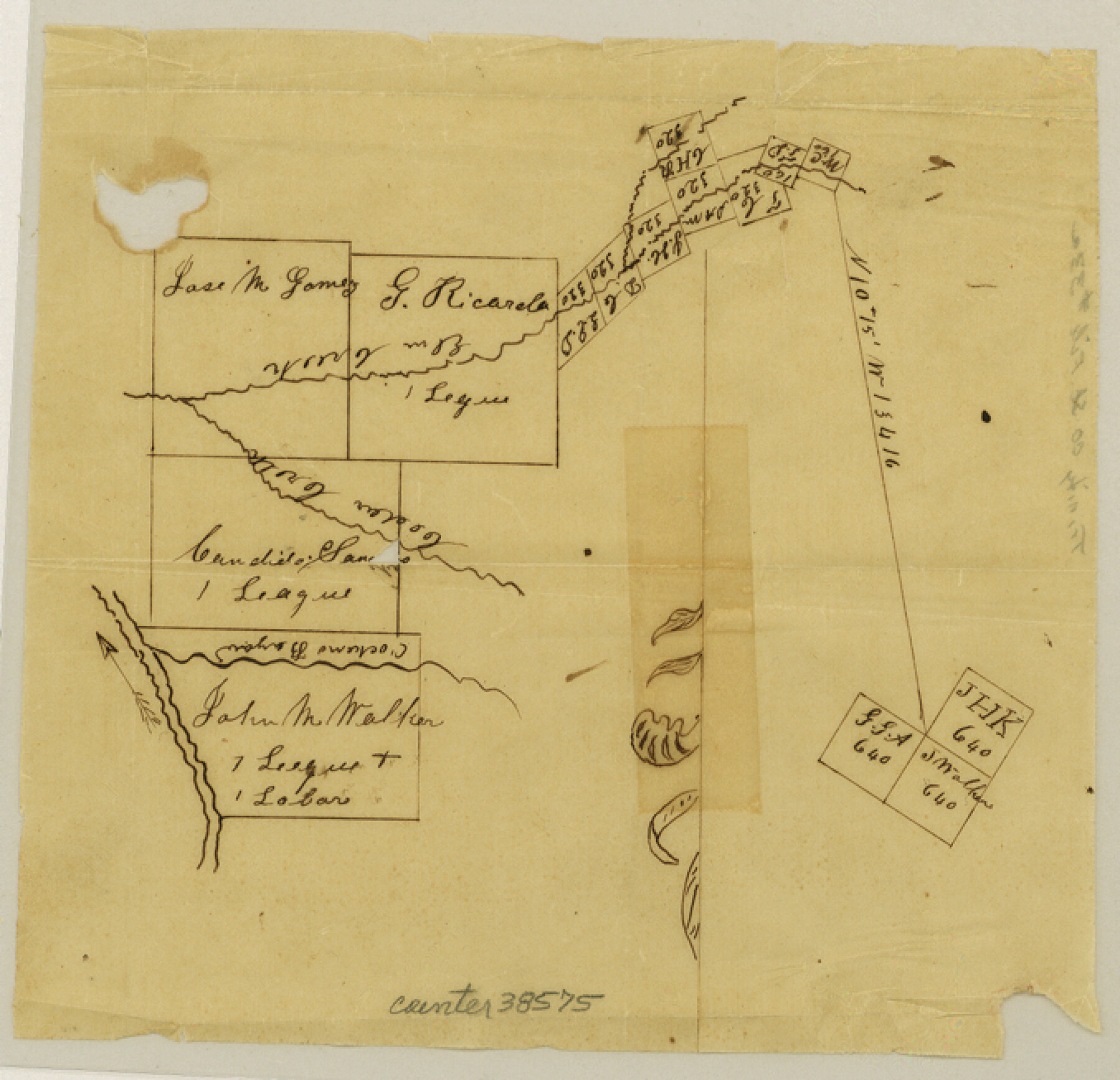
Trinity County Sketch File 33A
[Sketch and explanation regarding I. & G. N. R.R. Co. survey no. 20 and surrounding area]
-
Map/Doc
38575
-
Collection
General Map Collection
-
Object Dates
7/5/1920 (Creation Date)
7/10/1920 (File Date)
-
People and Organizations
J.M. O'Neill (Surveyor/Engineer)
-
Counties
Trinity
-
Subjects
Surveying Sketch File
-
Height x Width
6.5 x 6.8 inches
16.5 x 17.3 cm
-
Medium
multi-page, multi-format
-
Features
Elm Creek
Cedar Creek
Cochino Bayou
Part of: General Map Collection
Flight Mission No. DQN-1K, Frame 35, Calhoun County

Print $20.00
- Digital $50.00
Flight Mission No. DQN-1K, Frame 35, Calhoun County
1953
Size 18.5 x 19.0 inches
Map/Doc 84140
Menard County Rolled Sketch 12

Print $20.00
- Digital $50.00
Menard County Rolled Sketch 12
Size 14.4 x 21.7 inches
Map/Doc 6758
Stonewall County Sketch File 25

Print $7.00
- Digital $50.00
Stonewall County Sketch File 25
1952
Size 26.7 x 43.3 inches
Map/Doc 10375
Texas, Copano Bay, Port Bay

Print $40.00
- Digital $50.00
Texas, Copano Bay, Port Bay
1934
Size 32.9 x 48.8 inches
Map/Doc 73432
Hudspeth County Rolled Sketch 41

Print $40.00
- Digital $50.00
Hudspeth County Rolled Sketch 41
1947
Size 11.3 x 96.3 inches
Map/Doc 9214
Flight Mission No. BRE-1P, Frame 56, Nueces County

Print $20.00
- Digital $50.00
Flight Mission No. BRE-1P, Frame 56, Nueces County
1956
Size 18.5 x 22.4 inches
Map/Doc 86645
Hardin County Sketch File 70

Print $4.00
- Digital $50.00
Hardin County Sketch File 70
1895
Size 11.2 x 9.0 inches
Map/Doc 25257
Dimmit County Working Sketch 23

Print $20.00
- Digital $50.00
Dimmit County Working Sketch 23
1954
Size 22.5 x 23.3 inches
Map/Doc 68684
United States - Gulf Coast - Padre I. and Laguna Madre Lat. 27° 12' to Lat. 26° 33' Texas

Print $20.00
- Digital $50.00
United States - Gulf Coast - Padre I. and Laguna Madre Lat. 27° 12' to Lat. 26° 33' Texas
1913
Size 27.1 x 18.3 inches
Map/Doc 72818

Wichita County Sketch File 24

Print $20.00
- Digital $50.00
Wichita County Sketch File 24
1919
Size 17.3 x 24.0 inches
Map/Doc 12684
Maverick County Rolled Sketch 24

Print $20.00
- Digital $50.00
Maverick County Rolled Sketch 24
1975
Size 31.4 x 30.7 inches
Map/Doc 6715
You may also like
Chart of the West Indies and Spanish Dominions in North America

Print $20.00
- Digital $50.00
Chart of the West Indies and Spanish Dominions in North America
1803
Size 25.7 x 39.4 inches
Map/Doc 97137
[Right of Way & Track Map, The Texas & Pacific Ry. Co. Main Line]
![64665, [Right of Way & Track Map, The Texas & Pacific Ry. Co. Main Line], General Map Collection](https://historictexasmaps.com/wmedia_w700/maps/64665.tif.jpg)
Print $20.00
- Digital $50.00
[Right of Way & Track Map, The Texas & Pacific Ry. Co. Main Line]
Size 11.0 x 18.4 inches
Map/Doc 64665
[Sections 47-76 and part of Block 3]
![91807, [Sections 47-76 and part of Block 3], Twichell Survey Records](https://historictexasmaps.com/wmedia_w700/maps/91807-1.tif.jpg)
Print $20.00
- Digital $50.00
[Sections 47-76 and part of Block 3]
Size 34.1 x 31.7 inches
Map/Doc 91807
Map of Lipscomb County

Print $20.00
- Digital $50.00
Map of Lipscomb County
1899
Size 43.1 x 39.2 inches
Map/Doc 5017
Angelina County

Print $40.00
- Digital $50.00
Angelina County
1945
Size 40.2 x 49.7 inches
Map/Doc 95417
Flight Mission No. BRA-16M, Frame 83, Jefferson County

Print $20.00
- Digital $50.00
Flight Mission No. BRA-16M, Frame 83, Jefferson County
1953
Size 18.5 x 22.3 inches
Map/Doc 85695
Travis County Working Sketch 14

Print $20.00
- Digital $50.00
Travis County Working Sketch 14
1937
Size 26.3 x 27.2 inches
Map/Doc 69398
Brazoria County NRC Article 33.136 Sketch 13

Print $42.00
- Digital $50.00
Brazoria County NRC Article 33.136 Sketch 13
2012
Size 36.0 x 23.0 inches
Map/Doc 95069
Taylor County Rolled Sketch 20

Print $20.00
- Digital $50.00
Taylor County Rolled Sketch 20
Size 25.6 x 33.9 inches
Map/Doc 7914
Zavala County Boundary File 2a

Print $56.00
- Digital $50.00
Zavala County Boundary File 2a
Size 14.2 x 8.8 inches
Map/Doc 60248
Culberson County Working Sketch 65

Print $40.00
- Digital $50.00
Culberson County Working Sketch 65
1975
Size 49.0 x 34.9 inches
Map/Doc 68519
Map of Gillespie County

Print $20.00
- Digital $50.00
Map of Gillespie County
1857
Size 35.1 x 26.2 inches
Map/Doc 3582