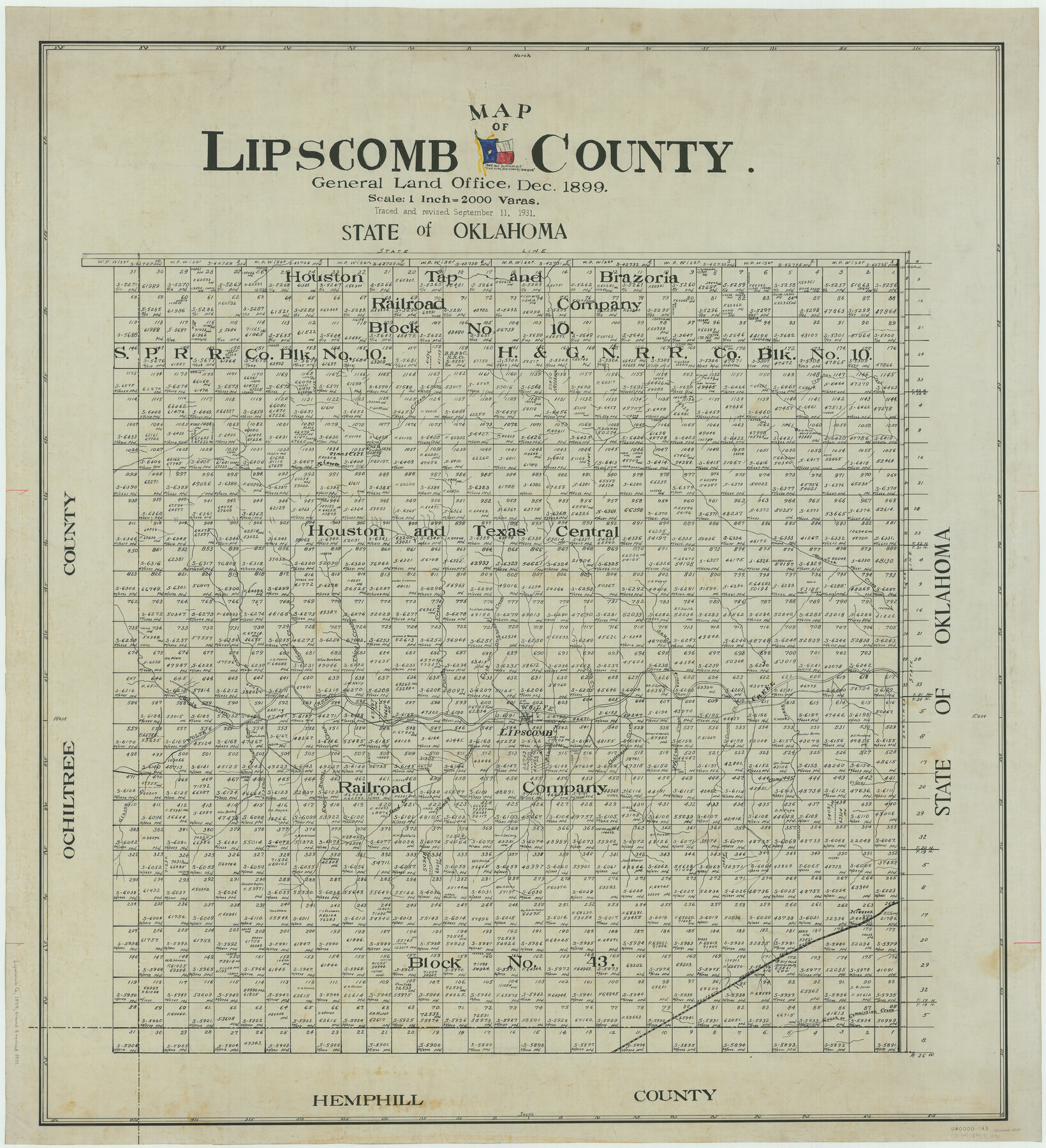
Map of Lipscomb County
-
Map/Doc
5017
-
Collection
General Map Collection
-
Object Dates
1899 (Creation Date)
-
People and Organizations
Texas General Land Office (Publisher)
-
Counties
Lipscomb
-
Subjects
County
-
Height x Width
43.1 x 39.2 inches
109.5 x 99.6 cm
-
Comments
Traced and revised September 11, 1931.
Part of: General Map Collection
Floyd County Working Sketch 4

Print $20.00
- Digital $50.00
Floyd County Working Sketch 4
1952
Size 23.2 x 29.0 inches
Map/Doc 69183
Baylor County

Print $20.00
- Digital $50.00
Baylor County
1961
Size 40.6 x 33.0 inches
Map/Doc 77209
Harris County Historic Topographic 27

Print $20.00
- Digital $50.00
Harris County Historic Topographic 27
1915
Size 19.8 x 23.5 inches
Map/Doc 65838
Sectional Map No. 4 of the lands and of the lines of the Texas & Pacific R'Y. Co. in El Paso and part of Presidio Co's.

Print $20.00
- Digital $50.00
Sectional Map No. 4 of the lands and of the lines of the Texas & Pacific R'Y. Co. in El Paso and part of Presidio Co's.
1885
Size 22.3 x 17.0 inches
Map/Doc 2304
Clay County Sketch File 43

Print $40.00
- Digital $50.00
Clay County Sketch File 43
1891
Size 23.2 x 33.7 inches
Map/Doc 11094
Burnet County Sketch File 16

Print $40.00
- Digital $50.00
Burnet County Sketch File 16
Size 15.8 x 12.8 inches
Map/Doc 16704
Harris County Sketch File 85

Print $20.00
- Digital $50.00
Harris County Sketch File 85
1894
Size 35.7 x 26.0 inches
Map/Doc 11673
Zapata County Rolled Sketch 7A

Print $20.00
- Digital $50.00
Zapata County Rolled Sketch 7A
1912
Size 17.9 x 26.6 inches
Map/Doc 8309
Arlington Street Map & Guide

Digital $50.00
Arlington Street Map & Guide
Size 35.4 x 23.0 inches
Map/Doc 94437
Flight Mission No. BRA-7M, Frame 136, Jefferson County

Print $20.00
- Digital $50.00
Flight Mission No. BRA-7M, Frame 136, Jefferson County
1953
Size 18.7 x 22.5 inches
Map/Doc 85530
Crockett County Sketch File A

Print $40.00
- Digital $50.00
Crockett County Sketch File A
Size 21.9 x 7.5 inches
Map/Doc 19624
Palo Pinto County Sketch File 22

Print $20.00
- Digital $50.00
Palo Pinto County Sketch File 22
1939
Size 19.6 x 15.0 inches
Map/Doc 12134
You may also like
Culberson County Working Sketch 7

Print $20.00
- Digital $50.00
Culberson County Working Sketch 7
1912
Size 21.2 x 17.7 inches
Map/Doc 68459
Flight Mission No. BQY-4M, Frame 122, Harris County

Print $20.00
- Digital $50.00
Flight Mission No. BQY-4M, Frame 122, Harris County
1953
Size 18.6 x 22.4 inches
Map/Doc 85290
Flight Mission No. DQN-7K, Frame 39, Calhoun County

Print $20.00
- Digital $50.00
Flight Mission No. DQN-7K, Frame 39, Calhoun County
1953
Size 19.0 x 22.5 inches
Map/Doc 84477
Aransas County Rolled Sketch 19A

Print $20.00
- Digital $50.00
Aransas County Rolled Sketch 19A
1979
Size 32.0 x 24.8 inches
Map/Doc 76068
Military Map of parts of Kansas, Nebraska and Dakota by Lieut. G.K. Warren, Top. Engrs. from the Explorations made by him in 1855, 56 & 57 exhibiting also routes reconnouered [sic] and surveyed by various other government officers
![93995, Military Map of parts of Kansas, Nebraska and Dakota by Lieut. G.K. Warren, Top. Engrs. from the Explorations made by him in 1855, 56 & 57 exhibiting also routes reconnouered [sic] and surveyed by various other government officers, Rees-Jones Digital Map Collection](https://historictexasmaps.com/wmedia_w700/maps/93995-1.tif.jpg)
Print $20.00
- Digital $50.00
Military Map of parts of Kansas, Nebraska and Dakota by Lieut. G.K. Warren, Top. Engrs. from the Explorations made by him in 1855, 56 & 57 exhibiting also routes reconnouered [sic] and surveyed by various other government officers
Size 19.9 x 35.6 inches
Map/Doc 93995
Travis County State Real Property Sketch 2

Print $20.00
- Digital $50.00
Travis County State Real Property Sketch 2
1986
Size 34.0 x 35.5 inches
Map/Doc 61693
Ramsey State Farm of the Texas Prison System, Brazoria County

Print $4.00
- Digital $50.00
Ramsey State Farm of the Texas Prison System, Brazoria County
1932
Size 15.9 x 18.6 inches
Map/Doc 65273
[Beaumont, Sour Lake and Western Ry. Right of Way and Alignment - Frisco]
![64115, [Beaumont, Sour Lake and Western Ry. Right of Way and Alignment - Frisco], General Map Collection](https://historictexasmaps.com/wmedia_w700/maps/64115.tif.jpg)
Print $20.00
- Digital $50.00
[Beaumont, Sour Lake and Western Ry. Right of Way and Alignment - Frisco]
1910
Size 20.1 x 45.9 inches
Map/Doc 64115
Baylor County Rolled Sketch 9

Print $20.00
- Digital $50.00
Baylor County Rolled Sketch 9
1892
Size 18.2 x 26.1 inches
Map/Doc 5125
Flight Mission No. CGI-3N, Frame 185, Cameron County

Print $20.00
- Digital $50.00
Flight Mission No. CGI-3N, Frame 185, Cameron County
1954
Size 18.6 x 22.4 inches
Map/Doc 84649
Shelby County Working Sketch 12

Print $40.00
- Digital $50.00
Shelby County Working Sketch 12
1946
Size 53.4 x 36.4 inches
Map/Doc 63865
Hood County Rolled Sketch 6A

Print $4.00
- Digital $50.00
Hood County Rolled Sketch 6A
1996
Size 19.9 x 26.5 inches
Map/Doc 6223