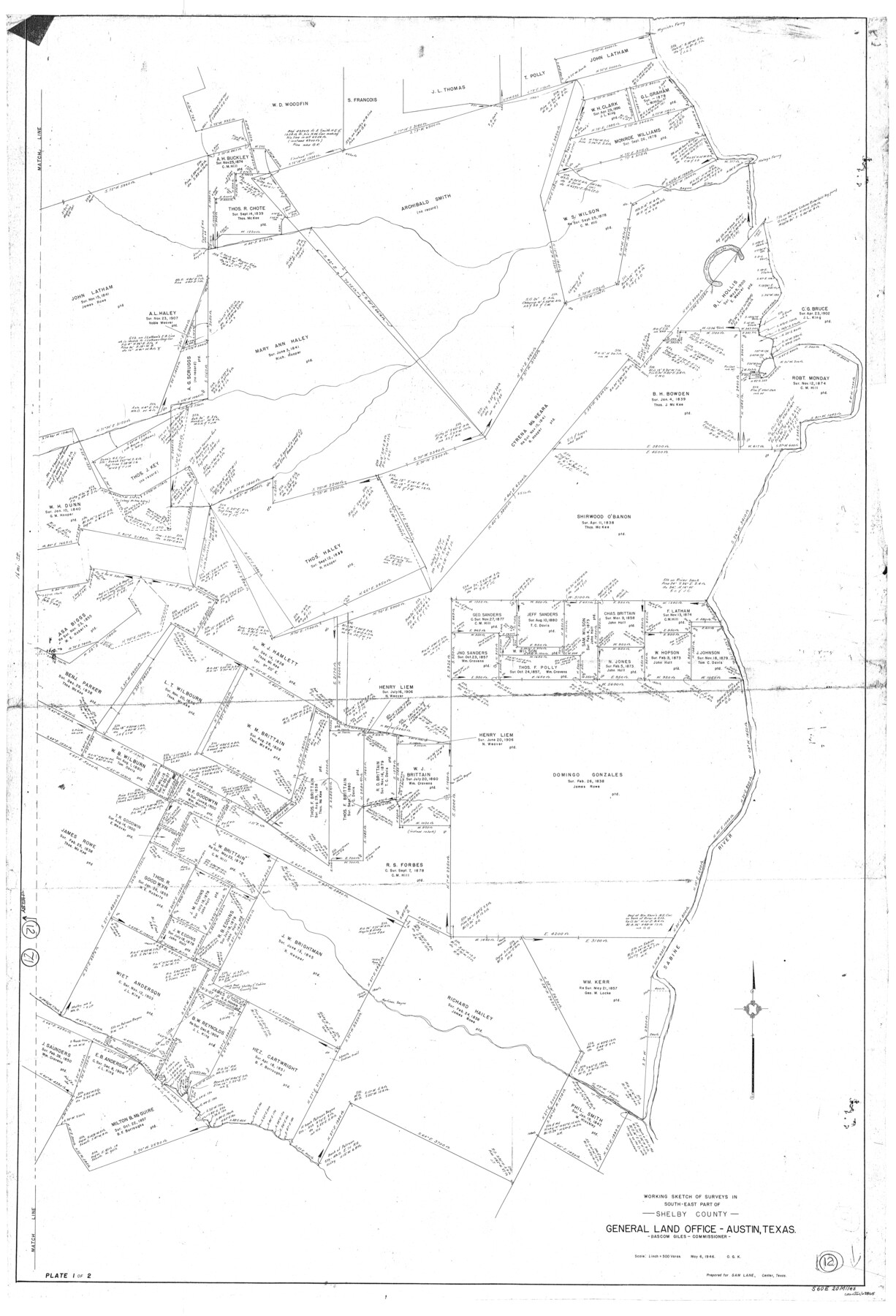
Shelby County Working Sketch 12
-
Map/Doc
63865
-
Collection
General Map Collection
-
Object Dates
5/6/1946 (Creation Date)
-
People and Organizations
Otto G. Kurio (Draftsman)
-
Counties
Shelby
-
Subjects
Surveying Working Sketch
-
Height x Width
53.4 x 36.4 inches
135.6 x 92.5 cm
-
Scale
1" = 500 varas
Part of: General Map Collection
Nueces County Rolled Sketch 13

Print $20.00
- Digital $50.00
Nueces County Rolled Sketch 13
1930
Size 26.5 x 18.5 inches
Map/Doc 6869
Trinity River, OwenCrossing Sheet/Elm Fork of Trinity River

Print $20.00
- Digital $50.00
Trinity River, OwenCrossing Sheet/Elm Fork of Trinity River
1914
Size 29.2 x 29.4 inches
Map/Doc 78340
Frio County Sketch File 2

Print $8.00
- Digital $50.00
Frio County Sketch File 2
Size 8.2 x 7.8 inches
Map/Doc 23104
Limestone County Sketch File 3

Print $4.00
- Digital $50.00
Limestone County Sketch File 3
1850
Size 7.9 x 10.7 inches
Map/Doc 30158
Karnes County Sketch File 12

Print $14.00
- Digital $50.00
Karnes County Sketch File 12
1889
Size 12.7 x 8.0 inches
Map/Doc 28604
[Sketch for Mineral Application 33721 - 33725 Incl. - Padre and Mustang Island]
![2873, [Sketch for Mineral Application 33721 - 33725 Incl. - Padre and Mustang Island], General Map Collection](https://historictexasmaps.com/wmedia_w700/maps/2873.tif.jpg)
Print $20.00
- Digital $50.00
[Sketch for Mineral Application 33721 - 33725 Incl. - Padre and Mustang Island]
1942
Size 26.6 x 22.7 inches
Map/Doc 2873
Trinity River, Five Mile Creek Sheet

Print $20.00
- Digital $50.00
Trinity River, Five Mile Creek Sheet
1923
Size 20.0 x 40.4 inches
Map/Doc 65197
Map of Bastrop County

Print $20.00
- Digital $50.00
Map of Bastrop County
1861
Size 26.3 x 29.0 inches
Map/Doc 3280
Blanco County Sketch File 18

Print $4.00
- Digital $50.00
Blanco County Sketch File 18
1877
Size 12.6 x 8.5 inches
Map/Doc 14594
Yoakum County Boundary File 1b

Print $2.00
- Digital $50.00
Yoakum County Boundary File 1b
Size 14.4 x 9.0 inches
Map/Doc 60197

Webb County Sketch File 10-2

Print $10.00
- Digital $50.00
Webb County Sketch File 10-2
1933
Size 16.9 x 10.9 inches
Map/Doc 39766
You may also like
Aransas County Sketch File 15a

Print $14.00
- Digital $50.00
Aransas County Sketch File 15a
Size 11.0 x 8.4 inches
Map/Doc 13136
Map of the State of Texas

Print $40.00
- Digital $50.00
Map of the State of Texas
1879
Size 102.3 x 56.2 inches
Map/Doc 93384
Chicago & Rock Island

Print $40.00
- Digital $50.00
Chicago & Rock Island
1892
Size 8.4 x 70.7 inches
Map/Doc 64498
Bastrop County Sketch File 1a

Print $4.00
- Digital $50.00
Bastrop County Sketch File 1a
Size 8.4 x 12.8 inches
Map/Doc 14040
Jefferson County Rolled Sketch 29

Print $20.00
- Digital $50.00
Jefferson County Rolled Sketch 29
1952
Size 31.8 x 43.6 inches
Map/Doc 9293

Winkler County Rolled Sketch 4

Print $40.00
- Digital $50.00
Winkler County Rolled Sketch 4
1927
Size 59.1 x 39.5 inches
Map/Doc 10147
Flight Mission No. CRC-3R, Frame 44, Chambers County

Print $20.00
- Digital $50.00
Flight Mission No. CRC-3R, Frame 44, Chambers County
1956
Size 18.6 x 22.3 inches
Map/Doc 84817
Clay County Sketch File 42

Print $20.00
- Digital $50.00
Clay County Sketch File 42
Size 22.8 x 31.0 inches
Map/Doc 11093
Knox County Working Sketch 16

Print $20.00
- Digital $50.00
Knox County Working Sketch 16
1963
Size 21.9 x 22.0 inches
Map/Doc 70258
Sabine County Sketch File 7a

Print $4.00
Sabine County Sketch File 7a
1882
Size 14.2 x 8.7 inches
Map/Doc 35620
Cochran County Working Sketch 1

Print $20.00
- Digital $50.00
Cochran County Working Sketch 1
1940
Size 21.1 x 35.9 inches
Map/Doc 68012