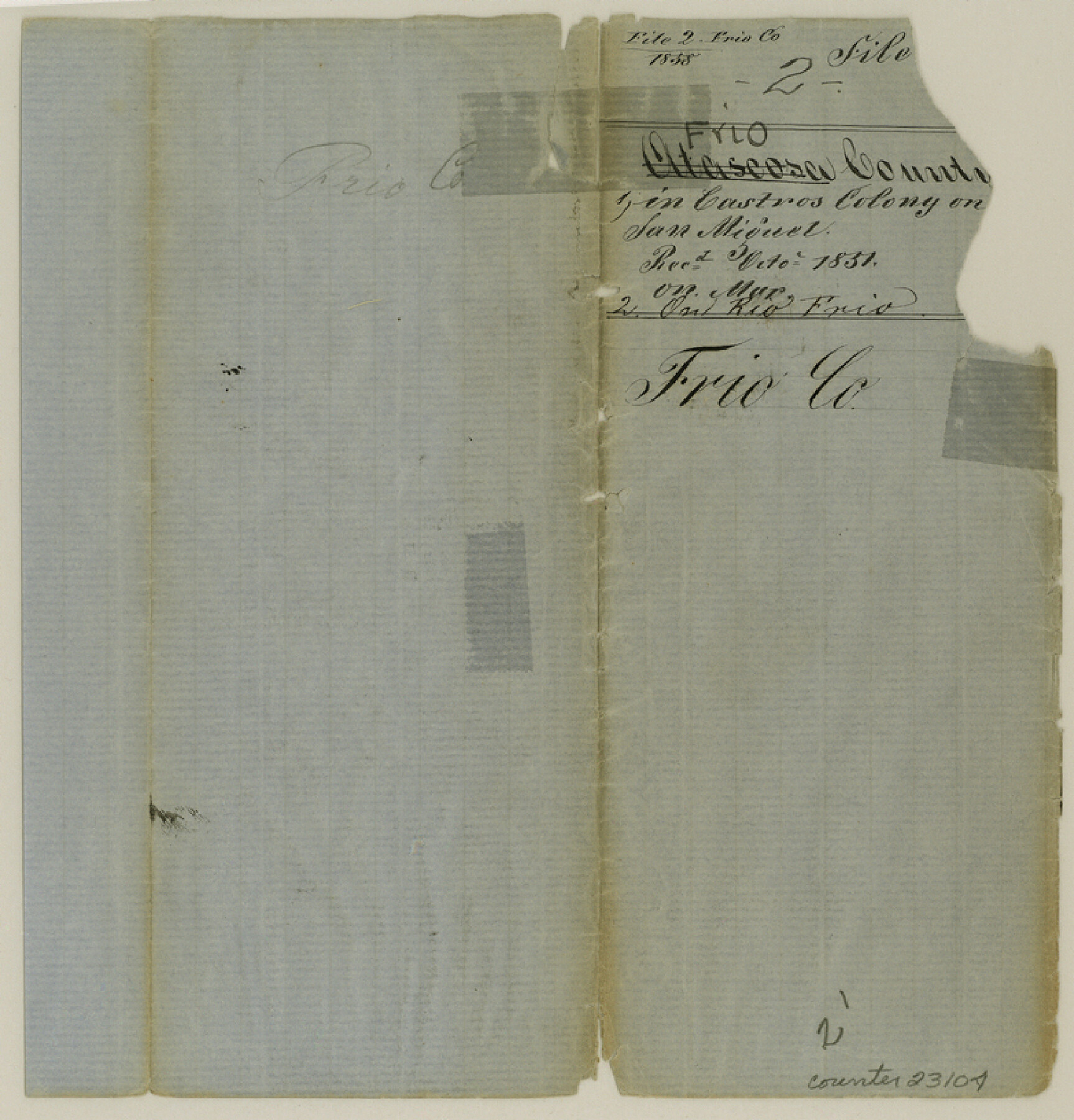
Frio County Sketch File 2
[Sketch of surveys in Castro's Colony on San Miguel]
-
Map/Doc
23104
-
Collection
General Map Collection
-
Object Dates
1851 (File Date)
-
Counties
Frio
-
Subjects
Surveying Sketch File
-
Height x Width
8.2 x 7.8 inches
20.8 x 19.8 cm
-
Medium
paper, manuscript
-
Features
San Miguel River
Escondido Creek
Gaspar Flores Creek
Part of: General Map Collection
Southern Part of Laguna Madre

Print $20.00
- Digital $50.00
Southern Part of Laguna Madre
1975
Size 44.8 x 35.5 inches
Map/Doc 73544
Dawson County Sketch File 1

Print $6.00
- Digital $50.00
Dawson County Sketch File 1
Size 7.5 x 3.9 inches
Map/Doc 20495
Brazoria County Rolled Sketch AM

Print $20.00
- Digital $50.00
Brazoria County Rolled Sketch AM
1935
Size 27.1 x 43.2 inches
Map/Doc 5189
Real County Rolled Sketch 18

Print $20.00
- Digital $50.00
Real County Rolled Sketch 18
Size 22.1 x 28.0 inches
Map/Doc 7467
Hemphill County Working Sketch 29

Print $40.00
- Digital $50.00
Hemphill County Working Sketch 29
1974
Size 61.7 x 43.4 inches
Map/Doc 66124
King County Working Sketch 6

Print $20.00
- Digital $50.00
King County Working Sketch 6
1944
Size 11.5 x 18.3 inches
Map/Doc 70170

Map of Jack County

Print $20.00
- Digital $50.00
Map of Jack County
1896
Size 20.3 x 17.7 inches
Map/Doc 3699
Eastland County Working Sketch 16

Print $20.00
- Digital $50.00
Eastland County Working Sketch 16
1919
Size 19.1 x 16.7 inches
Map/Doc 68797
San Jacinto River, Buff Lake Sheet 2/Caney Creek

Print $4.00
- Digital $50.00
San Jacinto River, Buff Lake Sheet 2/Caney Creek
1937
Size 24.1 x 24.7 inches
Map/Doc 65148
Val Verde County Sketch File 32

Print $20.00
- Digital $50.00
Val Verde County Sketch File 32
Size 45.1 x 20.1 inches
Map/Doc 10420
Gulf of Mexico

Print $20.00
- Digital $50.00
Gulf of Mexico
1908
Size 18.2 x 27.2 inches
Map/Doc 72658
You may also like
Childress County Rolled Sketch 18A

Print $20.00
- Digital $50.00
Childress County Rolled Sketch 18A
1913
Size 18.5 x 39.8 inches
Map/Doc 5452
Flight Mission No. DQO-1K, Frame 147, Galveston County

Print $20.00
- Digital $50.00
Flight Mission No. DQO-1K, Frame 147, Galveston County
1952
Size 18.8 x 22.4 inches
Map/Doc 85000
Edwards County Rolled Sketch 19

Print $20.00
- Digital $50.00
Edwards County Rolled Sketch 19
1947
Size 21.3 x 24.0 inches
Map/Doc 5808
Shackelford County Sketch File 13

Print $22.00
- Digital $50.00
Shackelford County Sketch File 13
1875
Size 12.8 x 15.8 inches
Map/Doc 36583
[South Center of County near surveys 1144 and 1143]
![90502, [South Center of County near surveys 1144 and 1143], Twichell Survey Records](https://historictexasmaps.com/wmedia_w700/maps/90502-1.tif.jpg)
Print $2.00
- Digital $50.00
[South Center of County near surveys 1144 and 1143]
Size 6.6 x 16.1 inches
Map/Doc 90502
Harris County Working Sketch 45

Print $20.00
- Digital $50.00
Harris County Working Sketch 45
1942
Size 26.6 x 31.9 inches
Map/Doc 65937
[Surveys along the Red River and Capitol Lands]
![90738, [Surveys along the Red River and Capitol Lands], Twichell Survey Records](https://historictexasmaps.com/wmedia_w700/maps/90738-1.tif.jpg)
Print $20.00
- Digital $50.00
[Surveys along the Red River and Capitol Lands]
Size 24.8 x 39.7 inches
Map/Doc 90738
Runnels County Working Sketch 3

Print $20.00
- Digital $50.00
Runnels County Working Sketch 3
1888
Size 22.1 x 20.3 inches
Map/Doc 63599
De Loache's Subdivision County School Leagues Hockley County, Texas

Print $20.00
- Digital $50.00
De Loache's Subdivision County School Leagues Hockley County, Texas
1924
Size 38.6 x 36.8 inches
Map/Doc 92235
Starr County Sketch File 41

Print $20.00
- Digital $50.00
Starr County Sketch File 41
1941
Size 26.6 x 31.1 inches
Map/Doc 12340
[Ft. W. & R. G. Ry. Right of Way Map, Chapin to Bluffdale, Hood County, Texas]
![64646, [Ft. W. & R. G. Ry. Right of Way Map, Chapin to Bluffdale, Hood County, Texas], General Map Collection](https://historictexasmaps.com/wmedia_w700/maps/64646.tif.jpg)
Print $40.00
- Digital $50.00
[Ft. W. & R. G. Ry. Right of Way Map, Chapin to Bluffdale, Hood County, Texas]
1918
Size 36.8 x 69.7 inches
Map/Doc 64646
General Highway Map, Harrison County, Texas

Print $20.00
General Highway Map, Harrison County, Texas
1961
Size 18.3 x 24.8 inches
Map/Doc 79509