Zavala County Rolled Sketch 14

Print $20.00
- Digital $50.00
Zavala County Rolled Sketch 14
1887
Size: 28.1 x 40.8 inches
10175
Atascosa County Sketch File 28

Print $40.00
- Digital $50.00
Atascosa County Sketch File 28
1878
Size: 27.9 x 21.7 inches
10862
Atascosa County Sketch File 35

Print $20.00
- Digital $50.00
Atascosa County Sketch File 35
1854
Size: 14.4 x 30.0 inches
10866
Frio County Sketch File 10

Print $20.00
- Digital $50.00
Frio County Sketch File 10
1906
Size: 19.3 x 23.2 inches
11518
Frio County Sketch File 19

Print $20.00
- Digital $50.00
Frio County Sketch File 19
1963
Size: 14.7 x 30.6 inches
11519
Frio County Sketch File 21

Print $20.00
- Digital $50.00
Frio County Sketch File 21
1938
Size: 23.4 x 24.3 inches
11520
La Salle County Sketch File 20A

Print $29.00
- Digital $50.00
La Salle County Sketch File 20A
1852
Size: 19.5 x 33.6 inches
11984
Zavala County Sketch File 1

Print $20.00
- Digital $50.00
Zavala County Sketch File 1
Size: 28.5 x 22.7 inches
12725
Zavala County Sketch File 43

Print $20.00
- Digital $50.00
Zavala County Sketch File 43
1915
Size: 26.8 x 32.4 inches
12733
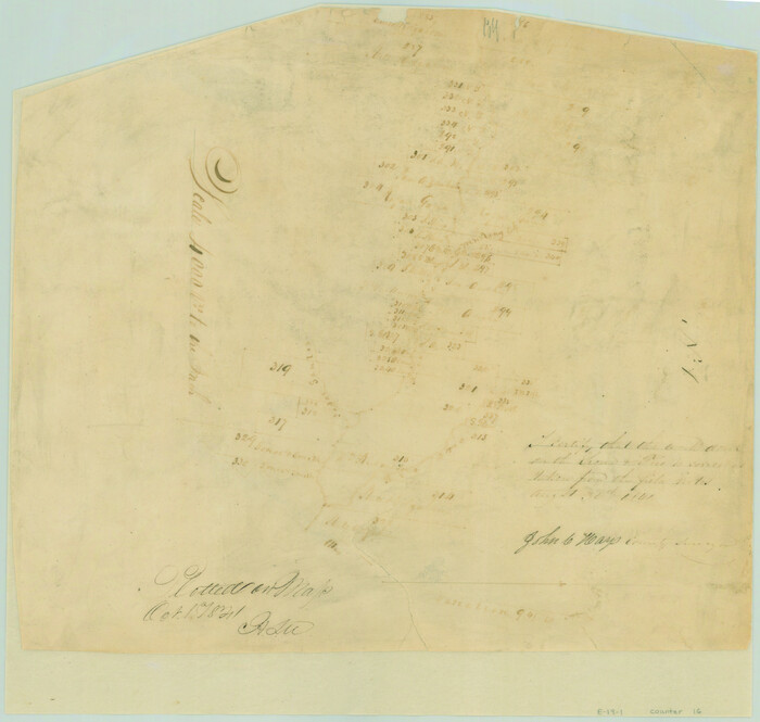
[Surveys in the Bexar District along the Medina River]
Print $20.00
- Digital $50.00
[Surveys in the Bexar District along the Medina River]
1841
Size: 23.0 x 16.8 inches
128
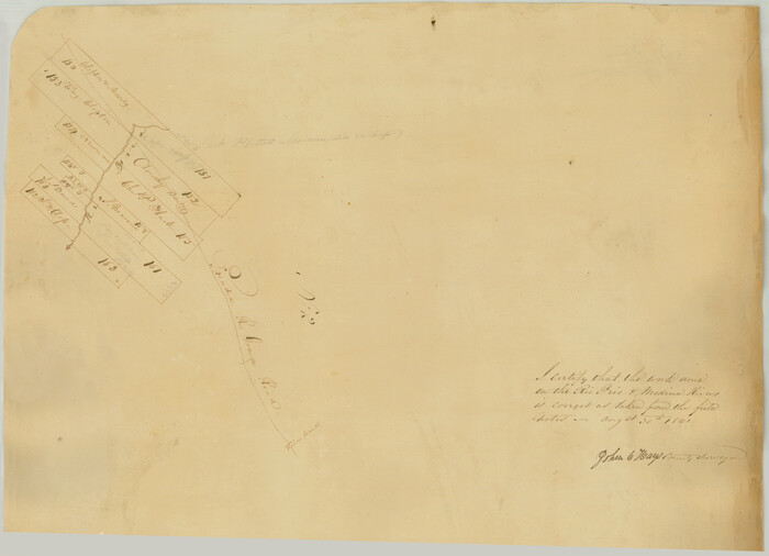
[Surveys along the Frio River]
Print $20.00
- Digital $50.00
[Surveys along the Frio River]
1841
Size: 12.0 x 16.6 inches
129
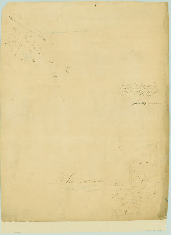
[Surveys in the Bexar District along the Frio and Leona Rivers]
Print $20.00
- Digital $50.00
[Surveys in the Bexar District along the Frio and Leona Rivers]
1842
Size: 16.2 x 12.2 inches
136
Atascosa County Sketch File 27c

Print $12.00
- Digital $50.00
Atascosa County Sketch File 27c
1876
Size: 12.7 x 8.4 inches
13806
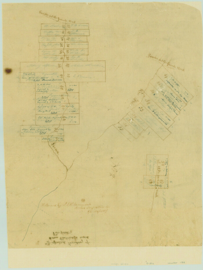
[Surveys along the Leona and Frio Rivers]
Print $20.00
- Digital $50.00
[Surveys along the Leona and Frio Rivers]
1841
Size: 12.4 x 13.1 inches
16
Map representing the surveys made in Bexar County

Print $40.00
- Digital $50.00
Map representing the surveys made in Bexar County
1839
Size: 76.0 x 68.4 inches
1947
Map of Castro's Colony - Bexar District

Print $20.00
- Digital $50.00
Map of Castro's Colony - Bexar District
1851
Size: 36.4 x 33.1 inches
1962
Frio County Sketch File A

Print $40.00
- Digital $50.00
Frio County Sketch File A
1878
Size: 16.4 x 13.4 inches
23099
Frio County Sketch File 1

Print $8.00
- Digital $50.00
Frio County Sketch File 1
1848
Size: 8.6 x 7.7 inches
23101
Frio County Sketch File 2

Print $8.00
- Digital $50.00
Frio County Sketch File 2
Size: 8.2 x 7.8 inches
23104
Frio County Sketch File 2a

Print $6.00
- Digital $50.00
Frio County Sketch File 2a
1861
Size: 16.0 x 11.0 inches
23107
Frio County Sketch File 3

Print $4.00
- Digital $50.00
Frio County Sketch File 3
1854
Size: 8.5 x 3.6 inches
23109
Frio County Sketch File 4

Print $4.00
- Digital $50.00
Frio County Sketch File 4
1877
Size: 8.0 x 9.6 inches
23111
Frio County Sketch File 4a

Print $6.00
- Digital $50.00
Frio County Sketch File 4a
1883
Size: 8.3 x 6.7 inches
23113
Frio County Sketch File 5

Print $4.00
- Digital $50.00
Frio County Sketch File 5
1878
Size: 7.9 x 11.2 inches
23116
Frio County Sketch File 6

Print $32.00
- Digital $50.00
Frio County Sketch File 6
1883
Size: 8.7 x 5.3 inches
23118
Frio County Sketch File 11

Print $4.00
- Digital $50.00
Frio County Sketch File 11
1912
Size: 8.4 x 11.2 inches
23125
Frio County Sketch File 12

Print $18.00
- Digital $50.00
Frio County Sketch File 12
1938
Size: 14.2 x 8.7 inches
23127
Frio County Sketch File 13

Print $10.00
- Digital $50.00
Frio County Sketch File 13
1948
Size: 11.3 x 8.8 inches
23136
Frio County Sketch File 14

Print $8.00
- Digital $50.00
Frio County Sketch File 14
1949
Size: 11.2 x 8.7 inches
23141
Zavala County Rolled Sketch 14
Print $20.00
- Digital $50.00
Zavala County Rolled Sketch 14
1887
-
Size
28.1 x 40.8 inches
-
Map/Doc
10175
-
Creation Date
1887
Atascosa County Sketch File 28
Print $40.00
- Digital $50.00
Atascosa County Sketch File 28
1878
-
Size
27.9 x 21.7 inches
-
Map/Doc
10862
-
Creation Date
1878
Atascosa County Sketch File 35
Print $20.00
- Digital $50.00
Atascosa County Sketch File 35
1854
-
Size
14.4 x 30.0 inches
-
Map/Doc
10866
-
Creation Date
1854
Frio County Sketch File 10
Print $20.00
- Digital $50.00
Frio County Sketch File 10
1906
-
Size
19.3 x 23.2 inches
-
Map/Doc
11518
-
Creation Date
1906
Frio County Sketch File 19
Print $20.00
- Digital $50.00
Frio County Sketch File 19
1963
-
Size
14.7 x 30.6 inches
-
Map/Doc
11519
-
Creation Date
1963
Frio County Sketch File 21
Print $20.00
- Digital $50.00
Frio County Sketch File 21
1938
-
Size
23.4 x 24.3 inches
-
Map/Doc
11520
-
Creation Date
1938
La Salle County Sketch File 20A
Print $29.00
- Digital $50.00
La Salle County Sketch File 20A
1852
-
Size
19.5 x 33.6 inches
-
Map/Doc
11984
-
Creation Date
1852
Zavala County Sketch File 1
Print $20.00
- Digital $50.00
Zavala County Sketch File 1
-
Size
28.5 x 22.7 inches
-
Map/Doc
12725
Zavala County Sketch File 43
Print $20.00
- Digital $50.00
Zavala County Sketch File 43
1915
-
Size
26.8 x 32.4 inches
-
Map/Doc
12733
-
Creation Date
1915
[Surveys in the Bexar District along the Medina River]
Print $20.00
- Digital $50.00
[Surveys in the Bexar District along the Medina River]
1841
-
Size
23.0 x 16.8 inches
-
Map/Doc
128
-
Creation Date
1841
[Surveys along the Frio River]
Print $20.00
- Digital $50.00
[Surveys along the Frio River]
1841
-
Size
12.0 x 16.6 inches
-
Map/Doc
129
-
Creation Date
1841
[Surveys in the Bexar District along the Frio and Leona Rivers]
Print $20.00
- Digital $50.00
[Surveys in the Bexar District along the Frio and Leona Rivers]
1842
-
Size
16.2 x 12.2 inches
-
Map/Doc
136
-
Creation Date
1842
Atascosa County Sketch File 27c
Print $12.00
- Digital $50.00
Atascosa County Sketch File 27c
1876
-
Size
12.7 x 8.4 inches
-
Map/Doc
13806
-
Creation Date
1876
[Surveys along the Leona and Frio Rivers]
Print $20.00
- Digital $50.00
[Surveys along the Leona and Frio Rivers]
1841
-
Size
12.4 x 13.1 inches
-
Map/Doc
16
-
Creation Date
1841
Frio County

Print $20.00
- Digital $50.00
Frio County
1944
-
Size
44.6 x 42.8 inches
-
Map/Doc
1832
-
Creation Date
1944
Map representing the surveys made in Bexar County
Print $40.00
- Digital $50.00
Map representing the surveys made in Bexar County
1839
-
Size
76.0 x 68.4 inches
-
Map/Doc
1947
-
Creation Date
1839
Map of Castro's Colony - Bexar District
Print $20.00
- Digital $50.00
Map of Castro's Colony - Bexar District
1851
-
Size
36.4 x 33.1 inches
-
Map/Doc
1962
-
Creation Date
1851
Frio County Sketch File A
Print $40.00
- Digital $50.00
Frio County Sketch File A
1878
-
Size
16.4 x 13.4 inches
-
Map/Doc
23099
-
Creation Date
1878
Frio County Sketch File 1
Print $8.00
- Digital $50.00
Frio County Sketch File 1
1848
-
Size
8.6 x 7.7 inches
-
Map/Doc
23101
-
Creation Date
1848
Frio County Sketch File 2
Print $8.00
- Digital $50.00
Frio County Sketch File 2
-
Size
8.2 x 7.8 inches
-
Map/Doc
23104
Frio County Sketch File 2a
Print $6.00
- Digital $50.00
Frio County Sketch File 2a
1861
-
Size
16.0 x 11.0 inches
-
Map/Doc
23107
-
Creation Date
1861
Frio County Sketch File 3
Print $4.00
- Digital $50.00
Frio County Sketch File 3
1854
-
Size
8.5 x 3.6 inches
-
Map/Doc
23109
-
Creation Date
1854
Frio County Sketch File 4
Print $4.00
- Digital $50.00
Frio County Sketch File 4
1877
-
Size
8.0 x 9.6 inches
-
Map/Doc
23111
-
Creation Date
1877
Frio County Sketch File 4a
Print $6.00
- Digital $50.00
Frio County Sketch File 4a
1883
-
Size
8.3 x 6.7 inches
-
Map/Doc
23113
-
Creation Date
1883
Frio County Sketch File 5
Print $4.00
- Digital $50.00
Frio County Sketch File 5
1878
-
Size
7.9 x 11.2 inches
-
Map/Doc
23116
-
Creation Date
1878
Frio County Sketch File 6
Print $32.00
- Digital $50.00
Frio County Sketch File 6
1883
-
Size
8.7 x 5.3 inches
-
Map/Doc
23118
-
Creation Date
1883
Frio County Sketch File 11
Print $4.00
- Digital $50.00
Frio County Sketch File 11
1912
-
Size
8.4 x 11.2 inches
-
Map/Doc
23125
-
Creation Date
1912
Frio County Sketch File 12
Print $18.00
- Digital $50.00
Frio County Sketch File 12
1938
-
Size
14.2 x 8.7 inches
-
Map/Doc
23127
-
Creation Date
1938
Frio County Sketch File 13
Print $10.00
- Digital $50.00
Frio County Sketch File 13
1948
-
Size
11.3 x 8.8 inches
-
Map/Doc
23136
-
Creation Date
1948
Frio County Sketch File 14
Print $8.00
- Digital $50.00
Frio County Sketch File 14
1949
-
Size
11.2 x 8.7 inches
-
Map/Doc
23141
-
Creation Date
1949