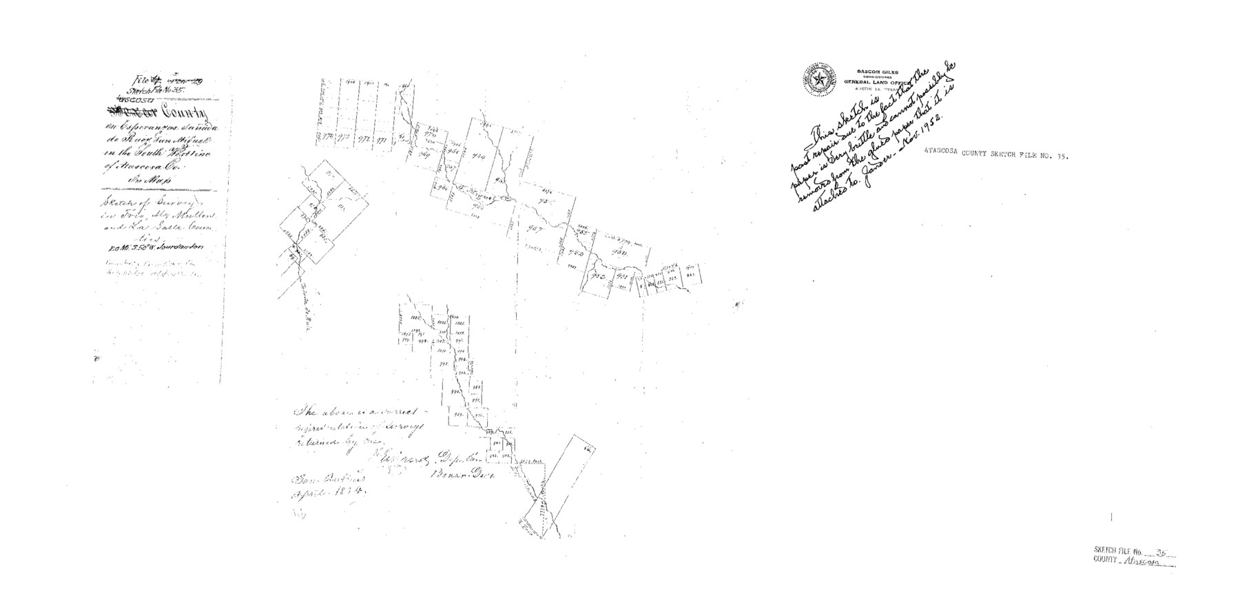
Atascosa County Sketch File 35
[Sketch of surveys along San Miguel Creek in southwest Atascosa County and other areas in Frio, La Salle, and McMullen Counties]
-
Map/Doc
10866
-
Collection
General Map Collection
-
Object Dates
1854 (Creation Date)
-
People and Organizations
F. Giraud (Surveyor/Engineer)
-
Counties
Atascosa Frio La Salle McMullen
-
Subjects
Surveying Sketch File
-
Height x Width
14.4 x 30.0 inches
36.6 x 76.2 cm
-
Medium
paper, manuscript
-
Features
San Miguel Creek
Esperansas Creek
Frio River
Part of: General Map Collection

Liberty County Working Sketch 9

Print $20.00
- Digital $50.00
Liberty County Working Sketch 9
Size 34.6 x 27.3 inches
Map/Doc 70468
[Del Rio, Texas]
![2070, [Del Rio, Texas], General Map Collection](https://historictexasmaps.com/wmedia_w700/maps/2070-1.tif.jpg)
Print $20.00
- Digital $50.00
[Del Rio, Texas]
1886
Size 24.2 x 34.3 inches
Map/Doc 2070
Hockley County Boundary File 1

Print $8.00
- Digital $50.00
Hockley County Boundary File 1
Size 13.5 x 8.5 inches
Map/Doc 54798
Upshur County Working Sketch 15b

Print $20.00
- Digital $50.00
Upshur County Working Sketch 15b
1996
Size 36.7 x 29.4 inches
Map/Doc 69572
Cass County Working Sketch 17

Print $20.00
- Digital $50.00
Cass County Working Sketch 17
1958
Size 36.8 x 42.7 inches
Map/Doc 67920
Jim Hogg County

Print $20.00
- Digital $50.00
Jim Hogg County
1962
Size 41.3 x 30.0 inches
Map/Doc 73197
Jeff Davis Co.

Print $20.00
- Digital $50.00
Jeff Davis Co.
1887
Size 37.5 x 47.9 inches
Map/Doc 4991
Pecos County Working Sketch 9

Print $20.00
- Digital $50.00
Pecos County Working Sketch 9
1907
Size 32.4 x 26.7 inches
Map/Doc 71479
Brewster County Sketch File FN-34

Print $40.00
- Digital $50.00
Brewster County Sketch File FN-34
1943
Size 23.1 x 27.1 inches
Map/Doc 10984
Gregg County Boundary File 2

Print $8.00
- Digital $50.00
Gregg County Boundary File 2
Size 8.8 x 3.7 inches
Map/Doc 53984
Duval County Working Sketch 53

Print $20.00
- Digital $50.00
Duval County Working Sketch 53
1948
Size 34.7 x 37.5 inches
Map/Doc 68777
You may also like
El Paso County

Print $40.00
- Digital $50.00
El Paso County
1881
Size 52.6 x 42.4 inches
Map/Doc 89058
Brazoria County Rolled Sketch 36

Print $20.00
- Digital $50.00
Brazoria County Rolled Sketch 36
Size 18.5 x 25.0 inches
Map/Doc 5172
Greater Texas and the Coast Country - The Winter Garden

Greater Texas and the Coast Country - The Winter Garden
1911
Size 9.4 x 4.5 inches
Map/Doc 97057
Soil Map, Texas, Woodville Sheet

Print $20.00
- Digital $50.00
Soil Map, Texas, Woodville Sheet
1903
Size 13.2 x 14.3 inches
Map/Doc 3077
Harris County Rolled Sketch 96B

Print $20.00
- Digital $50.00
Harris County Rolled Sketch 96B
Size 15.8 x 15.6 inches
Map/Doc 10681
Map of Polk County

Print $20.00
- Digital $50.00
Map of Polk County
1856
Size 22.1 x 23.7 inches
Map/Doc 3961
Real County Working Sketch 91

Print $20.00
- Digital $50.00
Real County Working Sketch 91
1996
Size 22.0 x 20.0 inches
Map/Doc 71983
Map of Hall County

Print $20.00
- Digital $50.00
Map of Hall County
1900
Size 41.2 x 41.3 inches
Map/Doc 16842
Houston County Sketch File 1b

Print $4.00
- Digital $50.00
Houston County Sketch File 1b
1857
Size 8.5 x 7.9 inches
Map/Doc 26744
Hood County Working Sketch Graphic Index

Print $20.00
- Digital $50.00
Hood County Working Sketch Graphic Index
1941
Size 35.9 x 31.8 inches
Map/Doc 76580
Map of Central Texas Oil Fields

Print $20.00
Map of Central Texas Oil Fields
1918
Size 27.1 x 21.5 inches
Map/Doc 76295
Cottle County Sketch File 3

Print $4.00
- Digital $50.00
Cottle County Sketch File 3
Size 10.0 x 8.4 inches
Map/Doc 19457