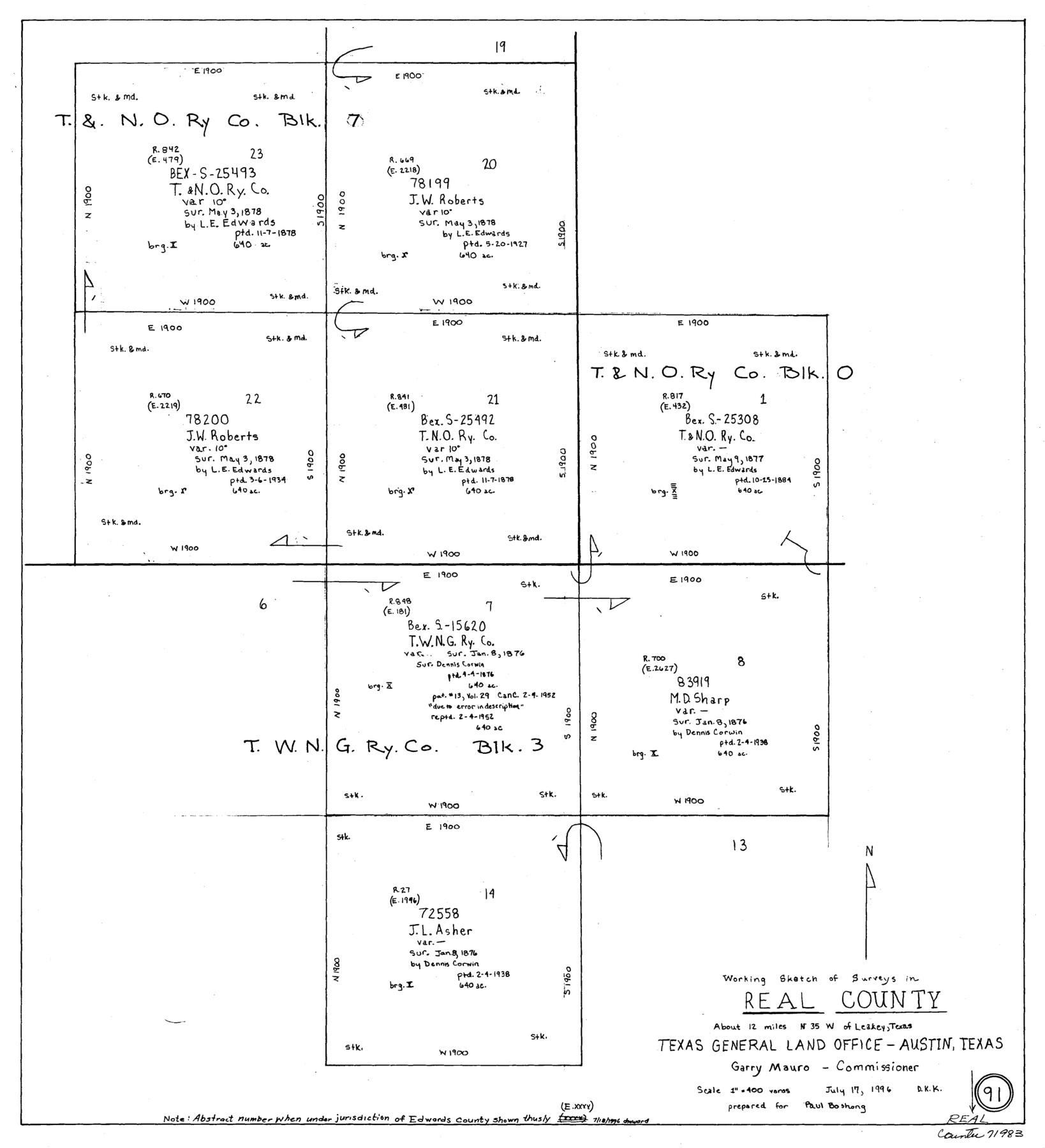
Real County Working Sketch 91
-
Map/Doc
71983
-
Collection
General Map Collection
-
Counties
Real
-
Subjects
Cadastral Surveying Working Sketch
-
Height x Width
22.0 x 20.0 inches
55.9 x 50.8 cm
Part of: General Map Collection
Flight Mission No. BQR-4K, Frame 61, Brazoria County
![83994, Flight Mission No. BQR-4K, Frame 61, Brazoria County, General Map Collection](https://historictexasmaps.com/wmedia_w700/pdf_converted_jpg/qi_pdf_thumbnail_31213.jpg)
Print $20.00
- Digital $50.00
Flight Mission No. BQR-4K, Frame 61, Brazoria County
1952
Size 18.7 x 22.5 inches
Map/Doc 83994
Polk County Working Sketch 19
![71634, Polk County Working Sketch 19, General Map Collection](https://historictexasmaps.com/wmedia_w700/maps/71634.tif.jpg)
Print $6.00
- Digital $50.00
Polk County Working Sketch 19
Size 34.0 x 26.5 inches
Map/Doc 71634
Flight Mission No. DCL-7C, Frame 24, Kenedy County
![86016, Flight Mission No. DCL-7C, Frame 24, Kenedy County, General Map Collection](https://historictexasmaps.com/wmedia_w700/pdf_converted_jpg/qi_pdf_thumbnail_33162.jpg)
Print $20.00
- Digital $50.00
Flight Mission No. DCL-7C, Frame 24, Kenedy County
1943
Size 15.5 x 15.4 inches
Map/Doc 86016
Presidio County Rolled Sketch 6
![9761, Presidio County Rolled Sketch 6, General Map Collection](https://historictexasmaps.com/wmedia_w700/maps/9761.tif.jpg)
Print $40.00
- Digital $50.00
Presidio County Rolled Sketch 6
1949
Size 56.8 x 32.2 inches
Map/Doc 9761
Reagan County Sketch File 18
![12219, Reagan County Sketch File 18, General Map Collection](https://historictexasmaps.com/wmedia_w700/pdf_converted_jpg/qi_pdf_thumbnail_8553.jpg)
Print $20.00
- Digital $50.00
Reagan County Sketch File 18
1936
Size 20.8 x 19.8 inches
Map/Doc 12219
Reeves County Working Sketch 22
![63465, Reeves County Working Sketch 22, General Map Collection](https://historictexasmaps.com/wmedia_w700/maps/63465.tif.jpg)
Print $20.00
- Digital $50.00
Reeves County Working Sketch 22
Size 31.2 x 46.8 inches
Map/Doc 63465
[Shelby District]
![69740, [Shelby District], General Map Collection](https://historictexasmaps.com/wmedia_w700/maps/69740.tif.jpg)
Print $2.00
- Digital $50.00
[Shelby District]
1845
Size 6.9 x 7.6 inches
Map/Doc 69740
Austin County Sketch File EF
![10879, Austin County Sketch File EF, General Map Collection](https://historictexasmaps.com/wmedia_w700/pdf_converted_jpg/qi_pdf_thumbnail_7465.jpg)
Print $40.00
- Digital $50.00
Austin County Sketch File EF
1895
Size 15.1 x 17.0 inches
Map/Doc 10879
Flight Mission No. BRA-7M, Frame 197, Jefferson County
![85565, Flight Mission No. BRA-7M, Frame 197, Jefferson County, General Map Collection](https://historictexasmaps.com/wmedia_w700/pdf_converted_jpg/qi_pdf_thumbnail_32764.jpg)
Print $20.00
- Digital $50.00
Flight Mission No. BRA-7M, Frame 197, Jefferson County
1953
Size 18.6 x 22.4 inches
Map/Doc 85565
Hudspeth County Sketch File 4a
![26889, Hudspeth County Sketch File 4a, General Map Collection](https://historictexasmaps.com/wmedia_w700/pdf_converted_jpg/qi_pdf_thumbnail_12025.jpg)
Print $22.00
- Digital $50.00
Hudspeth County Sketch File 4a
1858
Size 16.4 x 14.3 inches
Map/Doc 26889
Street guide and metropolitan map of New Orleans [Recto]
![94198, Street guide and metropolitan map of New Orleans [Recto], General Map Collection](https://historictexasmaps.com/wmedia_w700/maps/94198.tif.jpg)
Street guide and metropolitan map of New Orleans [Recto]
1963
Size 18.3 x 27.2 inches
Map/Doc 94198
Marion County
![77365, Marion County, General Map Collection](https://historictexasmaps.com/wmedia_w700/maps/77365.tif.jpg)
Print $20.00
- Digital $50.00
Marion County
1943
Size 24.3 x 41.2 inches
Map/Doc 77365
You may also like
Chambers County Working Sketch 7
![67990, Chambers County Working Sketch 7, General Map Collection](https://historictexasmaps.com/wmedia_w700/maps/67990.tif.jpg)
Print $20.00
- Digital $50.00
Chambers County Working Sketch 7
Size 30.6 x 39.6 inches
Map/Doc 67990
Karnes County Sketch File 9
![28594, Karnes County Sketch File 9, General Map Collection](https://historictexasmaps.com/wmedia_w700/pdf_converted_jpg/qi_pdf_thumbnail_12358.jpg)
Print $6.00
- Digital $50.00
Karnes County Sketch File 9
1876
Size 12.6 x 8.1 inches
Map/Doc 28594
Dickens County Rolled Sketch P3
![8785, Dickens County Rolled Sketch P3, General Map Collection](https://historictexasmaps.com/wmedia_w700/maps/8785.tif.jpg)
Print $20.00
- Digital $50.00
Dickens County Rolled Sketch P3
1917
Size 41.4 x 36.1 inches
Map/Doc 8785
Starr County Boundary File 1
![58801, Starr County Boundary File 1, General Map Collection](https://historictexasmaps.com/wmedia_w700/pdf_converted_jpg/qi_pdf_thumbnail_16798.jpg)
Print $24.00
- Digital $50.00
Starr County Boundary File 1
Size 13.0 x 8.5 inches
Map/Doc 58801
Pecos County Working Sketch 103
![71576, Pecos County Working Sketch 103, General Map Collection](https://historictexasmaps.com/wmedia_w700/maps/71576.tif.jpg)
Print $40.00
- Digital $50.00
Pecos County Working Sketch 103
Size 43.4 x 51.4 inches
Map/Doc 71576
Flight Mission No. DCL-7C, Frame 15, Kenedy County
![86007, Flight Mission No. DCL-7C, Frame 15, Kenedy County, General Map Collection](https://historictexasmaps.com/wmedia_w700/pdf_converted_jpg/qi_pdf_thumbnail_33153.jpg)
Print $20.00
- Digital $50.00
Flight Mission No. DCL-7C, Frame 15, Kenedy County
1943
Size 15.4 x 15.3 inches
Map/Doc 86007
La Florida / Peruviae Avriferæ Regionis Typus / Guastecan
![94100, La Florida / Peruviae Avriferæ Regionis Typus / Guastecan, General Map Collection](https://historictexasmaps.com/wmedia_w700/maps/94100.tif.jpg)
Print $20.00
- Digital $50.00
La Florida / Peruviae Avriferæ Regionis Typus / Guastecan
1584
Size 16.8 x 20.9 inches
Map/Doc 94100
Brewster County Sketch File N-1
![10961, Brewster County Sketch File N-1, General Map Collection](https://historictexasmaps.com/wmedia_w700/pdf_converted_jpg/qi_pdf_thumbnail_7534.jpg)
Print $40.00
- Digital $50.00
Brewster County Sketch File N-1
Size 16.6 x 22.1 inches
Map/Doc 10961
Real County Working Sketch 44
![71936, Real County Working Sketch 44, General Map Collection](https://historictexasmaps.com/wmedia_w700/maps/71936.tif.jpg)
Print $5.00
- Digital $50.00
Real County Working Sketch 44
Size 28.3 x 24.3 inches
Map/Doc 71936
Langtree's New Sectional Map of the State of Arkansas
![93987, Langtree's New Sectional Map of the State of Arkansas, Rees-Jones Digital Map Collection](https://historictexasmaps.com/wmedia_w700/maps/93987-1.tif.jpg)
Print $20.00
- Digital $50.00
Langtree's New Sectional Map of the State of Arkansas
Size 34.6 x 38.4 inches
Map/Doc 93987
Index sheet to accompany map of survey for connecting the inland waters along margin of the Gulf of Mexico from Donaldsonville in Louisiana to the Rio Grande River in Texas
![72695, Index sheet to accompany map of survey for connecting the inland waters along margin of the Gulf of Mexico from Donaldsonville in Louisiana to the Rio Grande River in Texas, General Map Collection](https://historictexasmaps.com/wmedia_w700/maps/72695.tif.jpg)
Print $20.00
- Digital $50.00
Index sheet to accompany map of survey for connecting the inland waters along margin of the Gulf of Mexico from Donaldsonville in Louisiana to the Rio Grande River in Texas
1874
Size 18.2 x 27.1 inches
Map/Doc 72695