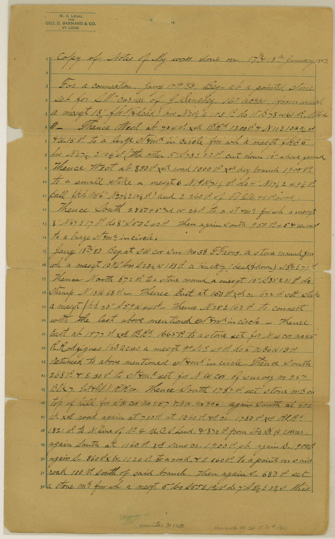
Maverick County Sketch File 13a
[Explanation of connecting line run northeast of mouth of Elm Creek]
-
Map/Doc
31108
-
Collection
General Map Collection
-
Object Dates
1/18/1883 (Creation Date)
-
People and Organizations
O.H. Hector (Surveyor/Engineer)
-
Counties
Maverick
-
Subjects
Surveying Sketch File
-
Height x Width
14.1 x 8.8 inches
35.8 x 22.4 cm
-
Medium
paper, manuscript
-
Features
Elm Creek
Part of: General Map Collection
Crane County Working Sketch 3

Print $20.00
- Digital $50.00
Crane County Working Sketch 3
1924
Size 36.2 x 34.4 inches
Map/Doc 68280
Harris County Working Sketch 2

Print $20.00
- Digital $50.00
Harris County Working Sketch 2
Size 32.3 x 31.7 inches
Map/Doc 65894
Newton County Working Sketch 31

Print $20.00
- Digital $50.00
Newton County Working Sketch 31
1955
Size 34.3 x 43.6 inches
Map/Doc 71277
San Patricio County Rolled Sketch 44

Print $55.00
- Digital $50.00
San Patricio County Rolled Sketch 44
1934
Size 9.8 x 14.9 inches
Map/Doc 48933
Jefferson County Rolled Sketch 32

Print $40.00
- Digital $50.00
Jefferson County Rolled Sketch 32
1955
Size 26.4 x 49.3 inches
Map/Doc 9295
Val Verde County Sketch File 40

Print $20.00
- Digital $50.00
Val Verde County Sketch File 40
1939
Size 15.3 x 25.5 inches
Map/Doc 12582
Goliad County Sketch File 28

Print $20.00
- Digital $50.00
Goliad County Sketch File 28
Size 18.9 x 15.5 inches
Map/Doc 11569
Flight Mission No. CUG-3P, Frame 18, Kleberg County

Print $20.00
- Digital $50.00
Flight Mission No. CUG-3P, Frame 18, Kleberg County
1956
Size 18.5 x 22.3 inches
Map/Doc 86228
Pecos County Boundary File 1a

Print $12.00
- Digital $50.00
Pecos County Boundary File 1a
Size 12.6 x 8.3 inches
Map/Doc 57855
[Liberty County, Texas]
![60297, [Liberty County, Texas], General Map Collection](https://historictexasmaps.com/wmedia_w700/maps/60297-1.tif.jpg)
Print $20.00
- Digital $50.00
[Liberty County, Texas]
1890
Size 24.2 x 16.9 inches
Map/Doc 60297
Brewster County Sketch File 42

Print $40.00
- Digital $50.00
Brewster County Sketch File 42
1914
Size 11.5 x 19.0 inches
Map/Doc 10981
Hood County Working Sketch 5

Print $20.00
- Digital $50.00
Hood County Working Sketch 5
1968
Size 20.7 x 29.1 inches
Map/Doc 66199
You may also like
Motley County Sketch File 12 (N)

Print $3.00
- Digital $50.00
Motley County Sketch File 12 (N)
Size 20.0 x 18.4 inches
Map/Doc 42141
Presidio County Rolled Sketch 2

Print $20.00
- Digital $50.00
Presidio County Rolled Sketch 2
Size 30.2 x 18.6 inches
Map/Doc 7326
Sterling County Working Sketch 2

Print $20.00
- Digital $50.00
Sterling County Working Sketch 2
1941
Size 19.9 x 26.2 inches
Map/Doc 63984
General Highway Map, Crockett County, Texas

Print $20.00
General Highway Map, Crockett County, Texas
1940
Size 18.3 x 25.1 inches
Map/Doc 79062
![90262, [Block M10], Twichell Survey Records](https://historictexasmaps.com/wmedia_w700/maps/90262-1.tif.jpg)
Pecos County Sketch File 25

Print $20.00
- Digital $50.00
Pecos County Sketch File 25
Size 17.6 x 24.9 inches
Map/Doc 12164
Dimmit County Working Sketch 46

Print $20.00
- Digital $50.00
Dimmit County Working Sketch 46
1980
Size 25.7 x 31.0 inches
Map/Doc 68707
[Surveys along the San Antonio Road near Caldwell]
![69760, [Surveys along the San Antonio Road near Caldwell], General Map Collection](https://historictexasmaps.com/wmedia_w700/maps/69760.tif.jpg)
Print $2.00
- Digital $50.00
[Surveys along the San Antonio Road near Caldwell]
1846
Size 9.2 x 7.7 inches
Map/Doc 69760
Montague County Working Sketch 17

Print $20.00
- Digital $50.00
Montague County Working Sketch 17
1947
Size 22.1 x 30.0 inches
Map/Doc 71083
Wharton County Sketch File 13

Print $26.00
- Digital $50.00
Wharton County Sketch File 13
1894
Size 14.0 x 8.7 inches
Map/Doc 39935
Starr County Sketch File 37

Print $10.00
- Digital $50.00
Starr County Sketch File 37
1940
Size 2.7 x 8.8 inches
Map/Doc 36980
Lynn County Sketch File 4

Print $12.00
- Digital $50.00
Lynn County Sketch File 4
1902
Size 12.8 x 8.2 inches
Map/Doc 30458