Newton County Sketch File 23
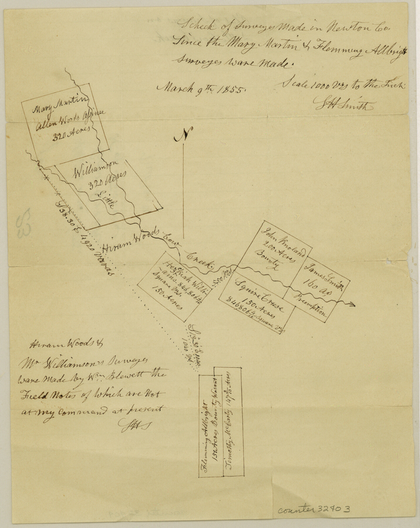
[Sketch of area in the vicinity of Little Cow Creek north of Newton]
-
Map/Doc
32403
-
Collection
General Map Collection
-
Object Dates
3/9/1855 (Creation Date)
-
People and Organizations
L.H. Smith (Surveyor/Engineer)
-
Counties
Newton
-
Subjects
Surveying Sketch File
-
Height x Width
10.1 x 8.0 inches
25.7 x 20.3 cm
-
Medium
paper, manuscript
-
Scale
1" = 1000 varas
-
Features
Little Cow Creek
Part of: General Map Collection
Nolan County Sketch File 1

Print $48.00
- Digital $50.00
Nolan County Sketch File 1
1890
Size 14.1 x 8.5 inches
Map/Doc 32470
Burnet County Working Sketch 27

Print $20.00
- Digital $50.00
Burnet County Working Sketch 27
2025
Size 24.5 x 36.0 inches
Map/Doc 97419

Hardin County Rolled Sketch 4

Print $20.00
- Digital $50.00
Hardin County Rolled Sketch 4
1938
Size 30.1 x 28.7 inches
Map/Doc 6077
Kendall County Rolled Sketch 6

Print $20.00
- Digital $50.00
Kendall County Rolled Sketch 6
Size 29.6 x 39.4 inches
Map/Doc 6459
Kinney County Rolled Sketch 16

Print $20.00
- Digital $50.00
Kinney County Rolled Sketch 16
1963
Size 36.4 x 43.8 inches
Map/Doc 9356
Texas 1971 Official State Highway Map

Digital $50.00
Texas 1971 Official State Highway Map
Size 27.9 x 36.3 inches
Map/Doc 94315
Orange County Working Sketch 16

Print $20.00
- Digital $50.00
Orange County Working Sketch 16
1929
Size 25.0 x 24.2 inches
Map/Doc 71348
McMullen County Working Sketch 44

Print $20.00
- Digital $50.00
McMullen County Working Sketch 44
1981
Size 35.1 x 41.2 inches
Map/Doc 70745
Webb County Sketch File 46-1

Print $20.00
- Digital $50.00
Webb County Sketch File 46-1
1939
Size 24.9 x 15.3 inches
Map/Doc 12645
Llano County Working Sketch 10

Print $20.00
- Digital $50.00
Llano County Working Sketch 10
1980
Size 21.2 x 15.1 inches
Map/Doc 70628
Flight Mission No. BQR-12K, Frame 50, Brazoria County

Print $20.00
- Digital $50.00
Flight Mission No. BQR-12K, Frame 50, Brazoria County
1952
Size 18.7 x 22.4 inches
Map/Doc 84065
You may also like
Hockley County

Print $20.00
- Digital $50.00
Hockley County
1897
Size 19.1 x 20.5 inches
Map/Doc 3675
Reeves County Working Sketch 28

Print $20.00
- Digital $50.00
Reeves County Working Sketch 28
1968
Size 34.4 x 42.1 inches
Map/Doc 63471
Travis County Appraisal District Plat Map 3_0104

Print $20.00
- Digital $50.00
Travis County Appraisal District Plat Map 3_0104
Size 21.5 x 26.4 inches
Map/Doc 94224
Duval County Rolled Sketch 40

Print $20.00
- Digital $50.00
Duval County Rolled Sketch 40
1958
Size 22.8 x 31.1 inches
Map/Doc 5757
Real County Working Sketch 89

Print $20.00
- Digital $50.00
Real County Working Sketch 89
Size 28.0 x 37.1 inches
Map/Doc 71981
Atascosa County Working Sketch 1a

Print $20.00
- Digital $50.00
Atascosa County Working Sketch 1a
1908
Size 35.8 x 40.2 inches
Map/Doc 67194
Burnet County Sketch File 6

Print $8.00
- Digital $50.00
Burnet County Sketch File 6
1854
Size 10.1 x 8.1 inches
Map/Doc 16682
Haskell County Sketch File 13

Print $37.00
- Digital $50.00
Haskell County Sketch File 13
Size 8.1 x 4.0 inches
Map/Doc 26142
Clay County Working Sketch 9

Print $20.00
- Digital $50.00
Clay County Working Sketch 9
1938
Size 37.5 x 29.4 inches
Map/Doc 68032
Donley County Working Sketch 5

Print $40.00
- Digital $50.00
Donley County Working Sketch 5
1957
Size 54.8 x 32.2 inches
Map/Doc 62185
Lampasas County Boundary File 17

Print $27.00
- Digital $50.00
Lampasas County Boundary File 17
Size 7.2 x 8.8 inches
Map/Doc 56236
Outer Continental Shelf Leasing Maps (Louisiana Offshore Operations)

Print $20.00
- Digital $50.00
Outer Continental Shelf Leasing Maps (Louisiana Offshore Operations)
1955
Size 11.1 x 13.3 inches
Map/Doc 76090