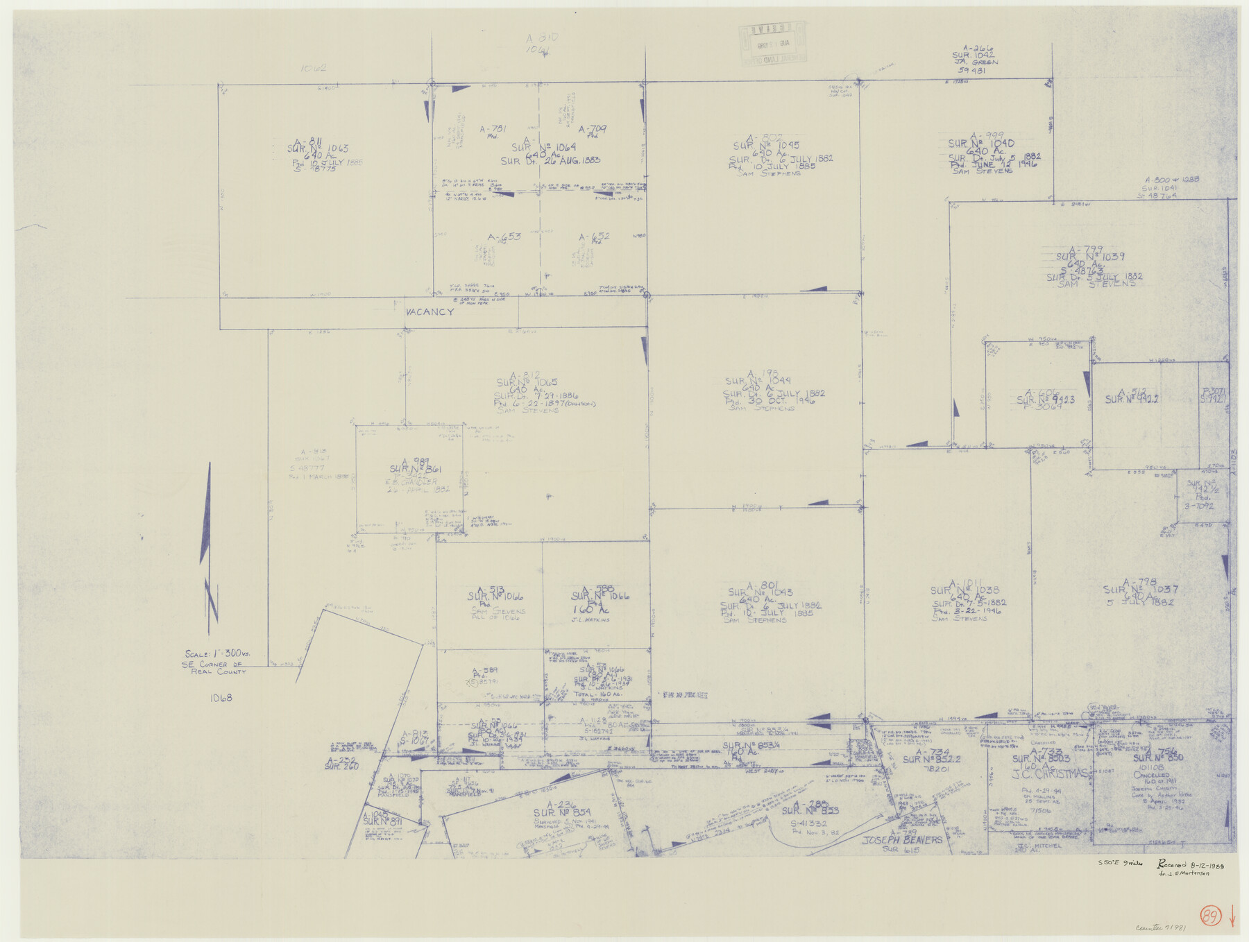
Real County Working Sketch 89
-
Map/Doc
71981
-
Collection
General Map Collection
-
Counties
Real
-
Subjects
Surveying Working Sketch
-
Height x Width
28.0 x 37.1 inches
71.1 x 94.2 cm
-
Scale
1" = 300 varas
Part of: General Map Collection
Flight Mission No. CRC-3R, Frame 7, Chambers County

Print $20.00
- Digital $50.00
Flight Mission No. CRC-3R, Frame 7, Chambers County
1956
Size 18.6 x 22.3 inches
Map/Doc 84781
Childress County Boundary File 1

Print $2.00
- Digital $50.00
Childress County Boundary File 1
Size 8.9 x 3.8 inches
Map/Doc 51305
Flight Mission No. DQO-8K, Frame 64, Galveston County

Print $20.00
- Digital $50.00
Flight Mission No. DQO-8K, Frame 64, Galveston County
1952
Size 18.6 x 22.4 inches
Map/Doc 85168
Matagorda County Rolled Sketch 9

Print $20.00
- Digital $50.00
Matagorda County Rolled Sketch 9
Size 36.8 x 30.0 inches
Map/Doc 6680
Sabine Bank to East Bay including Heald Bank

Print $20.00
- Digital $50.00
Sabine Bank to East Bay including Heald Bank
1982
Size 44.8 x 34.3 inches
Map/Doc 69852
Presidio County Sketch File A

Print $20.00
- Digital $50.00
Presidio County Sketch File A
Size 25.6 x 21.4 inches
Map/Doc 11700
Flight Mission No. DIX-10P, Frame 170, Aransas County

Print $20.00
- Digital $50.00
Flight Mission No. DIX-10P, Frame 170, Aransas County
1956
Size 18.7 x 22.3 inches
Map/Doc 83960
Trinity River, White Rock Reservoir Sheet/White Rock Creek

Print $6.00
- Digital $50.00
Trinity River, White Rock Reservoir Sheet/White Rock Creek
1923
Size 36.3 x 16.7 inches
Map/Doc 65213

Lee County Sketch File 2

Print $4.00
- Digital $50.00
Lee County Sketch File 2
Size 12.7 x 8.3 inches
Map/Doc 29680
Brazos Santiago & Boca Chica entrances, Texas

Print $20.00
- Digital $50.00
Brazos Santiago & Boca Chica entrances, Texas
1867
Size 18.1 x 25.6 inches
Map/Doc 72927
Crockett County Sketch File 74

Print $22.00
- Digital $50.00
Crockett County Sketch File 74
1933
Size 11.4 x 8.6 inches
Map/Doc 19872
You may also like
Pecos County Rolled Sketch 93

Print $40.00
- Digital $50.00
Pecos County Rolled Sketch 93
Size 50.3 x 42.8 inches
Map/Doc 9711
Eastland County Working Sketch 2

Print $20.00
- Digital $50.00
Eastland County Working Sketch 2
1915
Size 17.3 x 20.4 inches
Map/Doc 68783
Controlled Mosaic by Jack Amman Photogrammetric Engineers, Inc - Sheet 36

Print $20.00
- Digital $50.00
Controlled Mosaic by Jack Amman Photogrammetric Engineers, Inc - Sheet 36
1954
Size 20.0 x 24.0 inches
Map/Doc 83489
Brooks County Working Sketch 12

Print $20.00
- Digital $50.00
Brooks County Working Sketch 12
1943
Size 27.0 x 26.5 inches
Map/Doc 67796
Nueces County Rolled Sketch 125

Print $34.00
Nueces County Rolled Sketch 125
1998
Size 18.1 x 25.0 inches
Map/Doc 7160
Trinity River, South Extension Porters Bluff Sheet

Print $20.00
- Digital $50.00
Trinity River, South Extension Porters Bluff Sheet
1925
Size 16.3 x 24.4 inches
Map/Doc 69690
Archer County Sketch File 8

Print $40.00
- Digital $50.00
Archer County Sketch File 8
Size 40.9 x 31.5 inches
Map/Doc 10336
Leon County Working Sketch 55

Print $20.00
- Digital $50.00
Leon County Working Sketch 55
1989
Size 18.7 x 18.3 inches
Map/Doc 70455
Parts of Garza and Lynn Counties

Print $20.00
- Digital $50.00
Parts of Garza and Lynn Counties
1925
Size 23.1 x 17.0 inches
Map/Doc 91341
Lynn County Boundary File 10

Print $110.00
- Digital $50.00
Lynn County Boundary File 10
Size 14.3 x 8.7 inches
Map/Doc 56709
Hemphill County Sketch File 4

Print $14.00
- Digital $50.00
Hemphill County Sketch File 4
1903
Size 14.1 x 8.7 inches
Map/Doc 26288
Presidio County Sketch File 70b

Print $6.00
- Digital $50.00
Presidio County Sketch File 70b
Size 11.2 x 8.9 inches
Map/Doc 34671