Hemphill County Sketch File 4
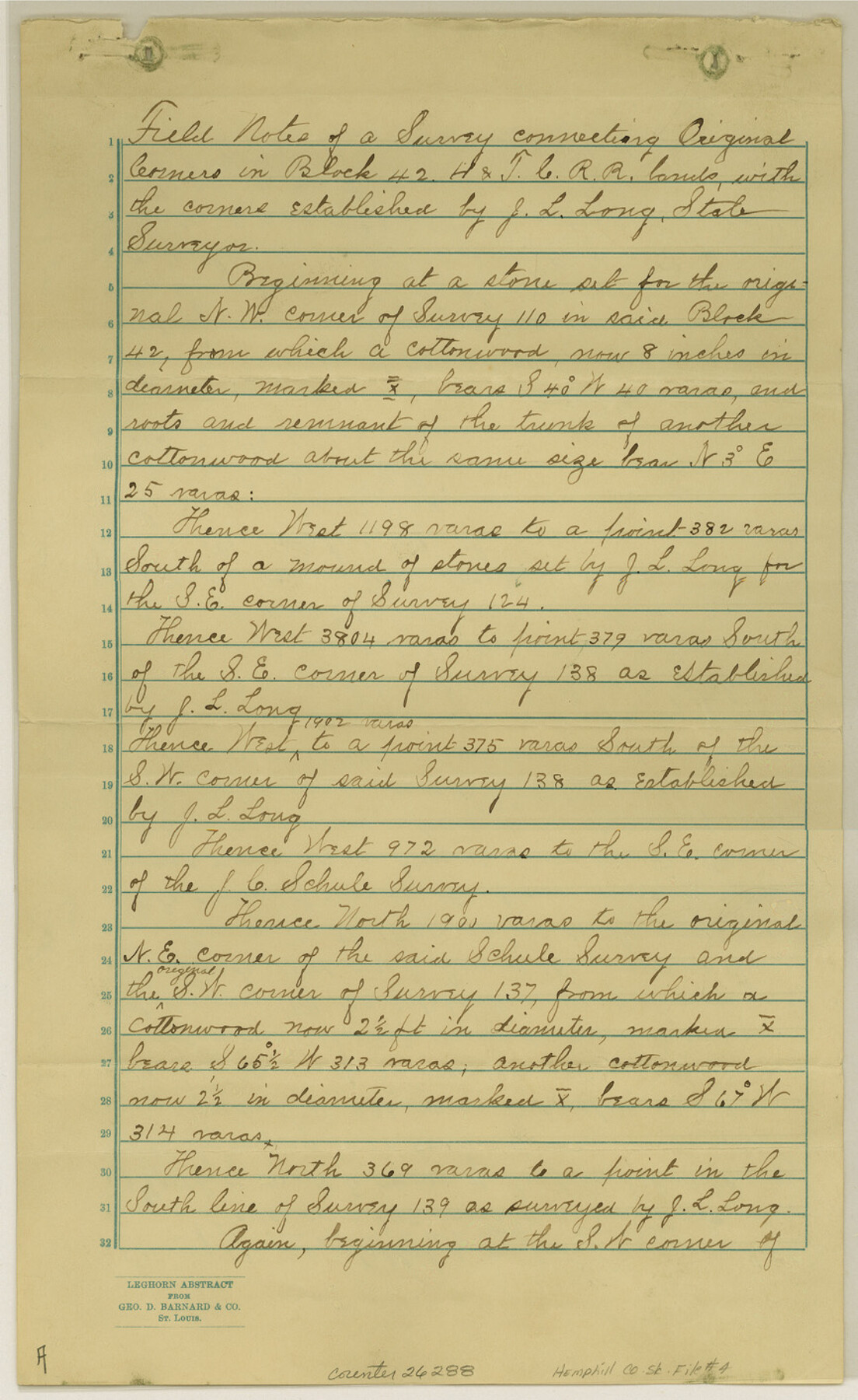
[Connecting line between original and re-located corners of Block 42, H. & T. C. RR. Co.]
-
Map/Doc
26288
-
Collection
General Map Collection
-
Object Dates
1/8/1903 (Creation Date)
1/23/1903 (File Date)
1/8/1903 (Survey Date)
2/1893 (Survey Date)
1888 (Survey Date)
-
People and Organizations
W.H.H. Cunningham (Surveyor/Engineer)
J.L. Long (Surveyor/Engineer)
James Cooper (Chainman)
R.M. Perkins (Chainman)
-
Counties
Hemphill Roberts
-
Subjects
Surveying Sketch File
-
Height x Width
14.1 x 8.7 inches
35.8 x 22.1 cm
-
Medium
paper, manuscript
-
Features
Canadian River
South Canadian River
Part of: General Map Collection
La Salle County Rolled Sketch 23A

Print $225.00
- Digital $50.00
La Salle County Rolled Sketch 23A
1956
Size 10.0 x 15.6 inches
Map/Doc 46481
Sketch showing progress of topographical work Laguna Madre and vicinity from Rainey Is. to Baffins Bay, Coast of Texas Sect. IX [and accompanying letter]
![72957, Sketch showing progress of topographical work Laguna Madre and vicinity from Rainey Is. to Baffins Bay, Coast of Texas Sect. IX [and accompanying letter], General Map Collection](https://historictexasmaps.com/wmedia_w700/maps/72957.tif.jpg)
Print $20.00
- Digital $50.00
Sketch showing progress of topographical work Laguna Madre and vicinity from Rainey Is. to Baffins Bay, Coast of Texas Sect. IX [and accompanying letter]
1880
Size 39.2 x 18.6 inches
Map/Doc 72957
Briscoe County Sketch File 6

Print $40.00
- Digital $50.00
Briscoe County Sketch File 6
Size 29.8 x 24.6 inches
Map/Doc 10995
Hays County Sketch File 32

Print $8.00
- Digital $50.00
Hays County Sketch File 32
Size 14.3 x 8.8 inches
Map/Doc 26264
Young County Sketch File 3

Print $4.00
- Digital $50.00
Young County Sketch File 3
1854
Size 12.3 x 8.2 inches
Map/Doc 40847
Galveston County NRC Article 33.136 Sketch 37

Print $22.00
- Digital $50.00
Galveston County NRC Article 33.136 Sketch 37
2006
Size 36.6 x 25.1 inches
Map/Doc 83551
Hopkins County Sketch File 9

Print $6.00
- Digital $50.00
Hopkins County Sketch File 9
1856
Size 12.8 x 8.3 inches
Map/Doc 26697
Hardin County Working Sketch 34

Print $20.00
- Digital $50.00
Hardin County Working Sketch 34
1980
Size 15.7 x 12.1 inches
Map/Doc 63432
Flight Mission No. DQN-6K, Frame 91, Calhoun County

Print $20.00
- Digital $50.00
Flight Mission No. DQN-6K, Frame 91, Calhoun County
1953
Size 18.5 x 22.2 inches
Map/Doc 84451
Hansford County Boundary File 1

Print $24.00
- Digital $50.00
Hansford County Boundary File 1
Size 9.2 x 8.6 inches
Map/Doc 54232
Edwards County Rolled Sketch 27

Print $20.00
- Digital $50.00
Edwards County Rolled Sketch 27
1959
Size 18.0 x 33.2 inches
Map/Doc 5813
Shackelford County Working Sketch 13

Print $20.00
- Digital $50.00
Shackelford County Working Sketch 13
1999
Size 18.6 x 16.2 inches
Map/Doc 63853
You may also like
Fannin County Boundary File 8

Print $8.00
- Digital $50.00
Fannin County Boundary File 8
Size 12.8 x 8.1 inches
Map/Doc 53316
Galveston County Sketch File 42

Print $20.00
- Digital $50.00
Galveston County Sketch File 42
1899
Size 23.9 x 23.7 inches
Map/Doc 11538
Crosby County

Print $20.00
- Digital $50.00
Crosby County
1927
Size 41.1 x 36.7 inches
Map/Doc 73123
Brazoria County NRC Article 33.136 Sketch 28

Print $24.00
Brazoria County NRC Article 33.136 Sketch 28
2025
Map/Doc 97473
Flight Mission No. DIX-5P, Frame 146, Aransas County

Print $20.00
- Digital $50.00
Flight Mission No. DIX-5P, Frame 146, Aransas County
1956
Size 17.7 x 17.9 inches
Map/Doc 83808
[Leagues 657- 666, 671- 674, 685- 687]
![91070, [Leagues 657- 666, 671- 674, 685- 687], Twichell Survey Records](https://historictexasmaps.com/wmedia_w700/maps/91070-1.tif.jpg)
Print $20.00
- Digital $50.00
[Leagues 657- 666, 671- 674, 685- 687]
Size 35.8 x 25.6 inches
Map/Doc 91070
Approaches to Galveston Bay

Print $40.00
- Digital $50.00
Approaches to Galveston Bay
1982
Size 53.1 x 36.7 inches
Map/Doc 69884
Galveston Bay Entrance - Galveston and Texas City Harbors

Print $40.00
- Digital $50.00
Galveston Bay Entrance - Galveston and Texas City Harbors
1973
Size 37.0 x 53.0 inches
Map/Doc 69863
Presidio County Rolled Sketch 147

Print $20.00
- Digital $50.00
Presidio County Rolled Sketch 147
2019
Size 35.2 x 24.1 inches
Map/Doc 95703
Galveston County Aerial Photograph Index Sheet 5

Print $20.00
- Digital $50.00
Galveston County Aerial Photograph Index Sheet 5
1953
Size 23.1 x 18.8 inches
Map/Doc 83696
Dickens County Sketch File D1

Print $50.00
- Digital $50.00
Dickens County Sketch File D1
Size 13.0 x 19.4 inches
Map/Doc 20833
Karte des Staates, Texas

Print $20.00
Karte des Staates, Texas
1851
Size 27.2 x 30.1 inches
Map/Doc 76262