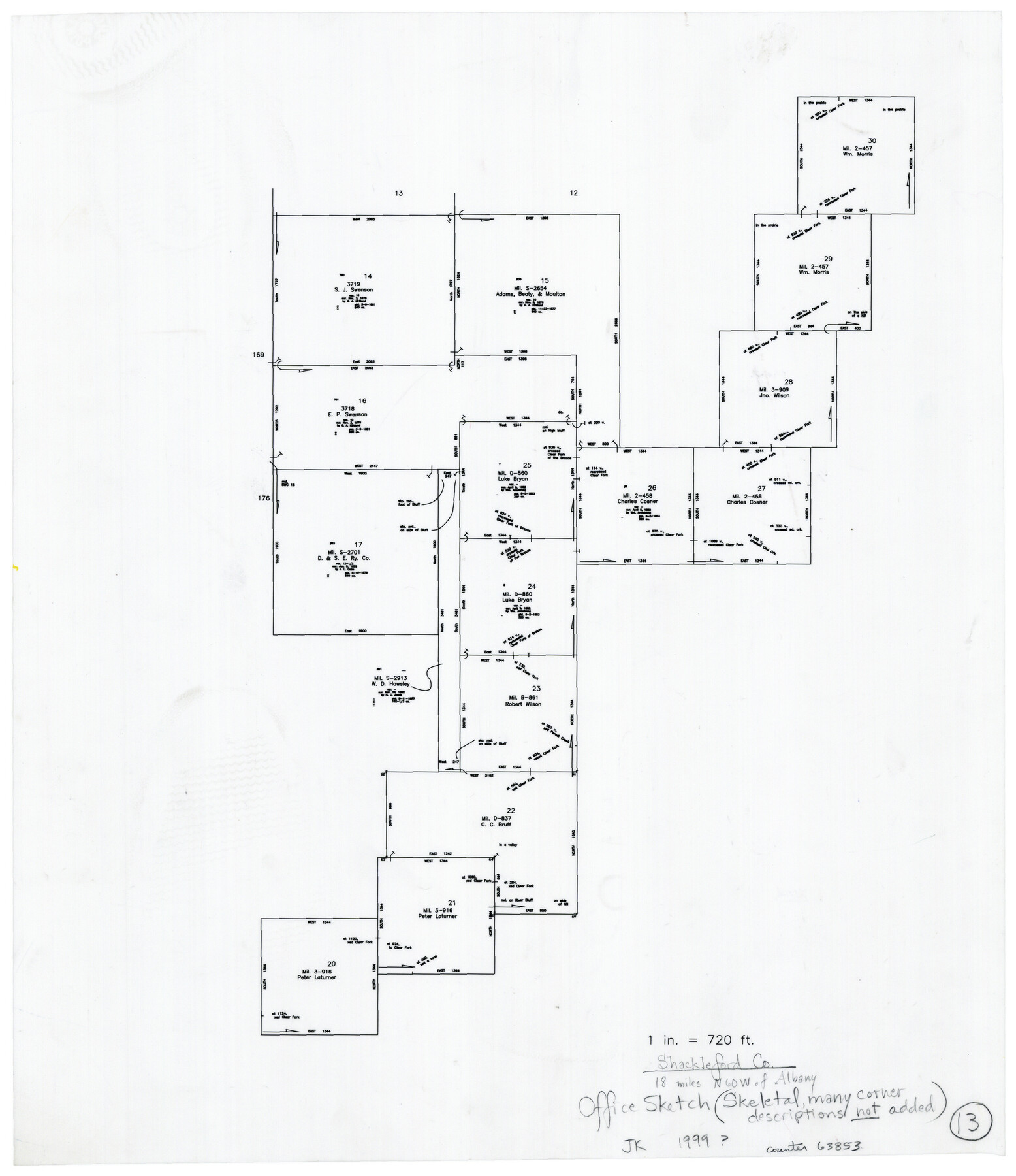
Shackelford County Working Sketch 13
-
Map/Doc
63853
-
Collection
General Map Collection
-
Object Dates
1999 ca. (Creation Date)
-
People and Organizations
Joan Kilpatrick (Draftsman)
-
Counties
Shackelford
-
Subjects
Surveying Working Sketch
-
Height x Width
18.6 x 16.2 inches
47.2 x 41.2 cm
-
Scale
1" = 720 feet
Part of: General Map Collection
Bosque County Working Sketch 11

Print $20.00
- Digital $50.00
Bosque County Working Sketch 11
1952
Size 10.8 x 30.4 inches
Map/Doc 67444
Bee County Sketch File 28

Print $6.00
- Digital $50.00
Bee County Sketch File 28
Size 14.4 x 8.7 inches
Map/Doc 14335
Flight Mission No. CGI-3N, Frame 179, Cameron County

Print $20.00
- Digital $50.00
Flight Mission No. CGI-3N, Frame 179, Cameron County
1954
Size 18.6 x 22.2 inches
Map/Doc 84643
Brazos River, Darrington-Ramsey Farms Project

Print $20.00
- Digital $50.00
Brazos River, Darrington-Ramsey Farms Project
1930
Size 37.5 x 26.8 inches
Map/Doc 69677
2017 Official Travel Map, Texas

2017 Official Travel Map, Texas
2017
Size 33.5 x 36.4 inches
Map/Doc 94414
Leon County Working Sketch 61

Print $20.00
- Digital $50.00
Leon County Working Sketch 61
2010
Size 35.8 x 38.7 inches
Map/Doc 89986
Montgomery County Working Sketch 57

Print $20.00
- Digital $50.00
Montgomery County Working Sketch 57
1961
Size 24.2 x 26.6 inches
Map/Doc 71164
Hockley County

Print $20.00
- Digital $50.00
Hockley County
1914
Size 27.4 x 22.8 inches
Map/Doc 4686
Harris County Working Sketch 69

Print $20.00
- Digital $50.00
Harris County Working Sketch 69
1956
Size 32.7 x 28.2 inches
Map/Doc 65961
Richardson's New Map of the State of Texas prepared for the Texas Almanac

Print $20.00
- Digital $50.00
Richardson's New Map of the State of Texas prepared for the Texas Almanac
1873
Size 19.8 x 27.1 inches
Map/Doc 96873
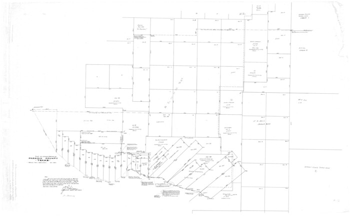
Presidio County Rolled Sketch D3
Print $40.00
- Digital $50.00
Presidio County Rolled Sketch D3
1909
Size 35.1 x 56.3 inches
Map/Doc 9776
Webb County Sketch File 25

Print $20.00
- Digital $50.00
Webb County Sketch File 25
1936
Size 18.2 x 30.7 inches
Map/Doc 12639
You may also like
Harris County Historic Topographic 7

Print $20.00
- Digital $50.00
Harris County Historic Topographic 7
1916
Size 20.4 x 23.4 inches
Map/Doc 65817
Harris County Working Sketch 47

Print $40.00
- Digital $50.00
Harris County Working Sketch 47
1942
Size 39.5 x 51.9 inches
Map/Doc 65939
Galveston County NRC Article 33.136 Location Key Sheet

Print $20.00
- Digital $50.00
Galveston County NRC Article 33.136 Location Key Sheet
1993
Size 27.3 x 23.0 inches
Map/Doc 83000
Runnels County Sketch File 23

Print $20.00
Runnels County Sketch File 23
1924
Size 21.2 x 19.9 inches
Map/Doc 12257
Glasscock County

Print $20.00
- Digital $50.00
Glasscock County
1887
Size 20.5 x 19.5 inches
Map/Doc 3584
Flight Mission No. CGI-4N, Frame 30, Cameron County

Print $20.00
- Digital $50.00
Flight Mission No. CGI-4N, Frame 30, Cameron County
1954
Size 18.6 x 22.3 inches
Map/Doc 84663

Baylor County Sketch File 1

Print $6.00
- Digital $50.00
Baylor County Sketch File 1
Size 17.5 x 11.4 inches
Map/Doc 14117
Map of Navarro County

Print $20.00
- Digital $50.00
Map of Navarro County
1872
Size 19.4 x 25.5 inches
Map/Doc 3910
Jeff Davis County Sketch File 43

Print $10.00
- Digital $50.00
Jeff Davis County Sketch File 43
1970
Size 14.2 x 8.6 inches
Map/Doc 28066
Morton, Cochran County, Texas

Print $40.00
- Digital $50.00
Morton, Cochran County, Texas
Size 44.4 x 53.5 inches
Map/Doc 89913
Jasper County Working Sketch 30

Print $20.00
- Digital $50.00
Jasper County Working Sketch 30
1956
Size 33.5 x 38.6 inches
Map/Doc 66492