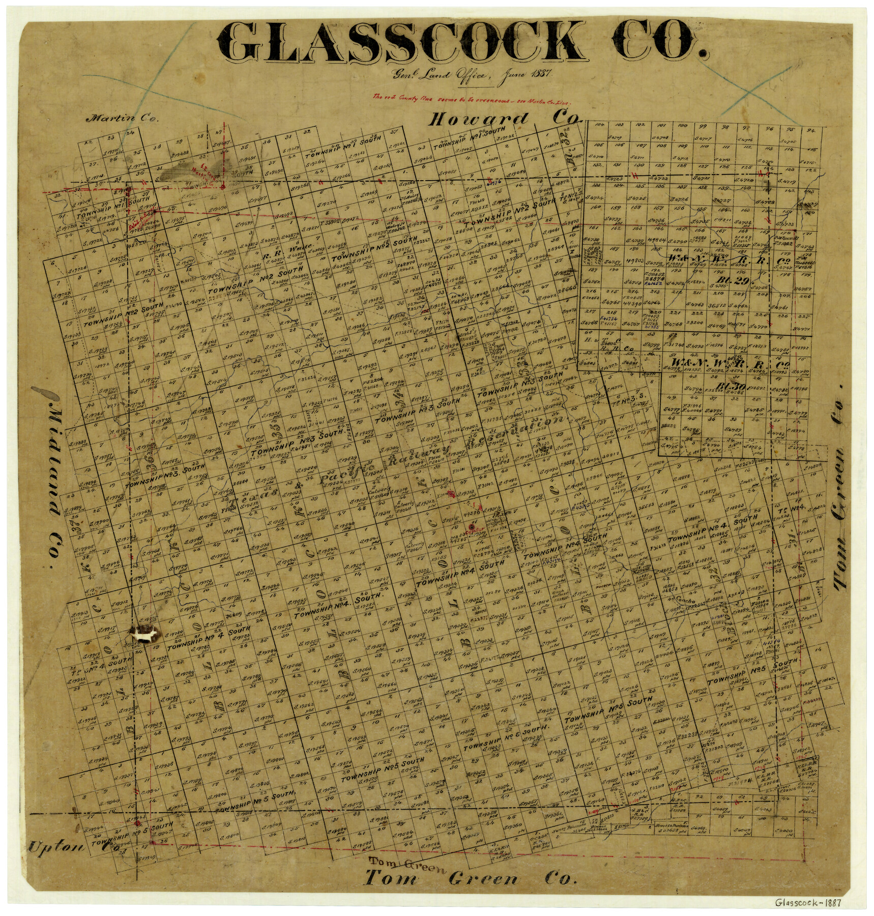
Glasscock County
-
Map/Doc
3584
-
Collection
General Map Collection
-
Object Dates
6/1887 (Creation Date)
-
People and Organizations
Texas General Land Office (Publisher)
-
Counties
Glasscock
-
Subjects
County
-
Height x Width
20.5 x 19.5 inches
52.1 x 49.5 cm
-
Features
Concho River
Part of: General Map Collection
Aransas County Working Sketch 8

Print $20.00
- Digital $50.00
Aransas County Working Sketch 8
1947
Size 24.7 x 24.2 inches
Map/Doc 67175
Presidio County Sketch File 28

Print $20.00
- Digital $50.00
Presidio County Sketch File 28
1890
Size 30.2 x 16.1 inches
Map/Doc 11709
Wichita County Sketch File 8

Print $4.00
- Digital $50.00
Wichita County Sketch File 8
1860
Size 11.7 x 8.2 inches
Map/Doc 40048
Harris County Texas

Print $20.00
- Digital $50.00
Harris County Texas
1908
Size 19.7 x 24.7 inches
Map/Doc 11652
Flight Mission No. DQO-7K, Frame 110, Galveston County

Print $20.00
- Digital $50.00
Flight Mission No. DQO-7K, Frame 110, Galveston County
1952
Size 18.7 x 22.3 inches
Map/Doc 85125
Waller County Sketch File 10

Print $4.00
- Digital $50.00
Waller County Sketch File 10
1912
Size 12.4 x 8.6 inches
Map/Doc 39612
Eastland County Rolled Sketch 18

Print $20.00
- Digital $50.00
Eastland County Rolled Sketch 18
Size 27.3 x 25.9 inches
Map/Doc 5776
Presidio County Rolled Sketch 143

Print $20.00
- Digital $50.00
Presidio County Rolled Sketch 143
Size 40.2 x 36.8 inches
Map/Doc 90046
Hartley County Boundary File 2

Print $52.00
- Digital $50.00
Hartley County Boundary File 2
Size 8.8 x 24.8 inches
Map/Doc 54453
Galveston County Sketch File 75

Print $12.00
- Digital $50.00
Galveston County Sketch File 75
2011
Size 11.0 x 8.5 inches
Map/Doc 95180
Navarro County Sketch File 20

Print $14.00
- Digital $50.00
Navarro County Sketch File 20
1967
Size 14.3 x 8.8 inches
Map/Doc 32343
Chambers County Sketch File Y

Print $4.00
- Digital $50.00
Chambers County Sketch File Y
1907
Size 14.3 x 8.7 inches
Map/Doc 17600
You may also like
Erath County Working Sketch 35

Print $20.00
- Digital $50.00
Erath County Working Sketch 35
1973
Size 24.8 x 28.4 inches
Map/Doc 69116
Cette Carte de Californie et du Nouveau Mexique est tiree de celle qui a ete envoyee par un grand d'Espagne pour etre communiquee a Mrs. de l'Academie Royale des Sciences

Print $20.00
- Digital $50.00
Cette Carte de Californie et du Nouveau Mexique est tiree de celle qui a ete envoyee par un grand d'Espagne pour etre communiquee a Mrs. de l'Academie Royale des Sciences
1700
Size 11.8 x 16.5 inches
Map/Doc 95924
[T. & G. Ry. Main Line, Texas, Right of Way Map, Center to Gary]
![64571, [T. & G. Ry. Main Line, Texas, Right of Way Map, Center to Gary], General Map Collection](https://historictexasmaps.com/wmedia_w700/maps/64571-1.tif.jpg)
Print $40.00
- Digital $50.00
[T. & G. Ry. Main Line, Texas, Right of Way Map, Center to Gary]
1917
Size 31.9 x 121.1 inches
Map/Doc 64571
Galveston County Rolled Sketch 23

Print $24.00
- Digital $50.00
Galveston County Rolled Sketch 23
1955
Size 10.0 x 15.2 inches
Map/Doc 45081
Sketch of surveys in Harrison & Marion Cos. Showing Caddo Lake & Subdivisions

Print $20.00
- Digital $50.00
Sketch of surveys in Harrison & Marion Cos. Showing Caddo Lake & Subdivisions
1955
Size 32.7 x 33.1 inches
Map/Doc 1928
Fannin County Sketch File 14

Print $6.00
- Digital $50.00
Fannin County Sketch File 14
1866
Size 14.5 x 9.6 inches
Map/Doc 22464
Flight Mission No. DQN-5K, Frame 44, Calhoun County

Print $20.00
- Digital $50.00
Flight Mission No. DQN-5K, Frame 44, Calhoun County
1953
Size 18.4 x 22.0 inches
Map/Doc 84389
Nueces County Rolled Sketch 75

Print $40.00
- Digital $50.00
Nueces County Rolled Sketch 75
1945
Size 56.0 x 24.0 inches
Map/Doc 9618
Carson County Boundary File 5 and 5a

Print $50.00
- Digital $50.00
Carson County Boundary File 5 and 5a
Size 8.8 x 4.4 inches
Map/Doc 51134
Sketch in Hays County

Print $2.00
- Digital $50.00
Sketch in Hays County
1889
Size 8.4 x 8.3 inches
Map/Doc 5038
Flight Mission No. DAG-17K, Frame 122, Matagorda County

Print $20.00
- Digital $50.00
Flight Mission No. DAG-17K, Frame 122, Matagorda County
1952
Size 16.5 x 16.4 inches
Map/Doc 86342
Jim Hogg Co. / Brooks Co.

Print $20.00
- Digital $50.00
Jim Hogg Co. / Brooks Co.
1912
Size 33.0 x 43.6 inches
Map/Doc 4894